Map of Crawford County - Crawford County is a county located in the U.S. state of Illinois. Crawford County Map showing cities, highways, important places and water bodies. Get Where is Crawford County located in the map, major cities in Crawford county, population, areas, and places of interest.
Crawford County Map, Illinois
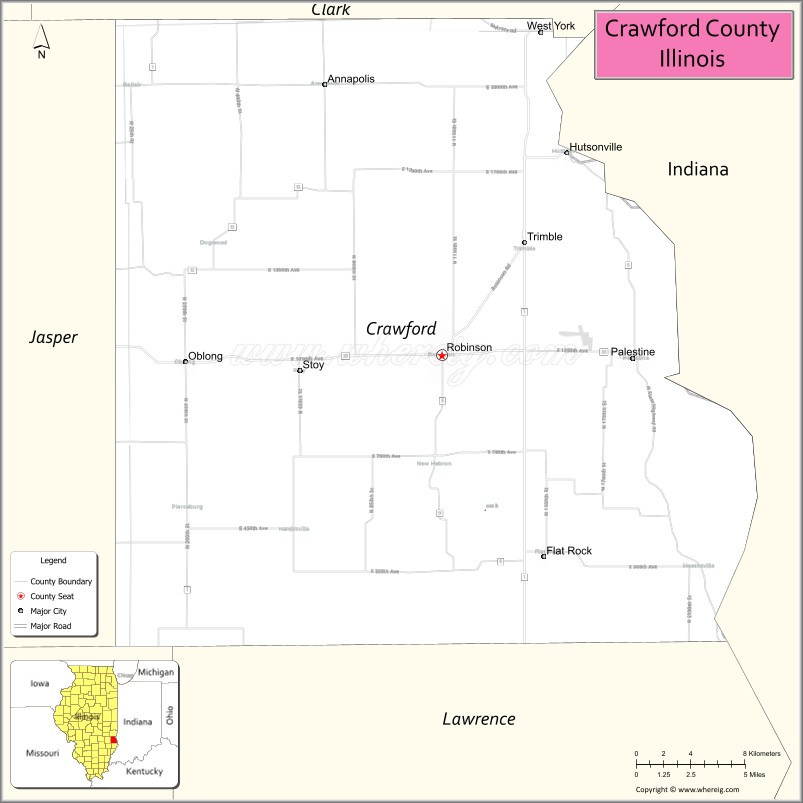
About Crawford County Map, Illinois: The map showing the county boundary, county seat, major cities, highways, water bodies and neighbouring counties.
Most Viewed Illinois Links
Crawford County, Illinois
Crawford County is a county located in the U.S. state of Illinois. It's county seat is Robinson. As per 2020 census, the population of Crawford County is 18659 people and population density is square miles. According to the United States Census Bureau, the county has a total area of 443 sq mi (1,147 km2). Crawford County was established on 1816.
Facts about Crawford County, Illinois
| Country | United States |
| State | Illinois |
| Region | Southeastern Illinois |
| County Seat | Robinson |
| Named After | William H. Crawford |
| Established | 1816 |
| Organized | 1816 |
| Coordinates | 39.00° N, 87.76° W |
| Total Area | ~446 sq mi |
| Land Area | ~444 sq mi |
| Water Area | ~2 sq mi |
| Population (2020) | ~18,509 |
| Population Rank | Small-to-mid-sized county in Illinois |
| Largest City | Robinson |
| Main Industries | Manufacturing, Energy, Agriculture, Healthcare |
| Major Highways | Interstate 70, Illinois Route 1 |
| Time Zone | Central Time (UTC−06:00) |
| Known For | Oil production history, industrial base, proximity to Indiana |
| Website | https://www.crawfordcountyil.gov |
Ctities in Crawford county
| City Name | Type | Population (2020) | Pop. Density | Area |
|---|---|---|---|---|
| Flat Rock | Village | 323 | 377.3/sq mi (145.7/km2) | 0.856 sq mi (2.22 km2) |
| Hutsonville | Village | 478 | 768.5/sq mi (296.7/km2) | 0.622 sq mi (1.61 km2) |
| Oblong | Village | 1,371 | 1,262.4/sq mi (487.4/km2) | 1.086 sq mi (2.81 km2) |
| Palestine | Village | 1,233 | 1,562.7/sq mi (603.4/km2) | 0.789 sq mi (2.04 km2) |
| Robinson | City | 7,150 | 1,521.6/sq mi (587.5/km2) | 4.699 sq mi (12.17 km2) |
| Stoy | Village | 108 | 115.9/sq mi (44.7/km2) | 0.932 sq mi (2.41 km2) |
Roads and Highways in Crawford County, Illinois
Crawford County is served by several major highways that provide easy access to eastern Illinois and neighboring Indiana.
- Interstate 70 – runs east-west through the county, connecting Robinson to Terre Haute and Effingham
- U.S. Route 50 – passes through the county, linking Robinson to Olney and Vincennes
- Illinois Route 1 – runs north-south, connecting Robinson to Lawrenceville and Marshall
- Illinois Route 33 – runs east-west, linking Robinson to Newton and Palestine
Neighboring Counties of Crawford County
- Clark County (north)
- Edgar County (northwest)
- Jasper County (west)
- Richland County (southwest)
- Lawrence County (south)
- Sullivan County, Indiana (east)
Top Attractions in Crawford County, Illinois
Crawford County offers a mix of outdoor recreation, local history, and small-town charm centered around the city of Robinson.
- Heath Harvest Festival – A popular annual event celebrating local agriculture and community spirit.
- Lincoln Trail College – A local college campus with cultural and community events.
- Robinson City Park – A relaxing park with playgrounds, trails, and picnic areas.
- Oblong Park – A community park with open space and recreational facilities.
- Crawford County Historical Society Museum – Showcases local history and heritage.
- Hutsonville Riverfront – Offers scenic views along the Wabash River.
- Quail Creek Country Club – A golf course with a peaceful setting.
Distance from Crawford County to Nearby Cities
- Robinson to Terre Haute – 35 mi (56 km)
- Robinson to Effingham – 50 mi (80 km)
- Robinson to Vincennes – 25 mi (40 km)
- Robinson to Champaign – 110 mi (177 km)
- Robinson to Indianapolis – 120 mi (193 km)
FAQs about Crawford County
Crawford County is located in eastern Illinois along the Indiana border.
The county is known for its community festivals, small-town atmosphere, and local parks.
Robinson is the county seat and the largest city in Crawford County.
Yes, visitors can enjoy parks, riverfront areas, and outdoor recreational spaces.
Crawford County is accessible via Interstate 70, U.S. Route 50, and Illinois Routes 1 and 33.
- Adams County Map
- Alexander County Map
- Bond County Map
- Boone County Map
- Brown County Map
- Bureau County Map
- Calhoun County Map
- Carroll County Map
- Cass County Map
- Champaign County Map
- Christian County Map
- Clark County Map
- Clay County Map
- Clinton County Map
- Coles County Map
- Cook County Map
- Crawford County Map
- Cumberland County Map
- DeKalb County Map
- DeWitt County Map
- Douglas County Map
- DuPage County Map
- Edgar County Map
- Edwards County Map
- Effingham County Map
- Fayette County Map
- Ford County Map
- Franklin County Map
- Fulton County Map
- Gallatin County Map
- Greene County Map
- Grundy County Map
- Hamilton County Map
- Hancock County Map
- Hardin County Map
- Henderson County Map
- Henry County Map
- Iroquois County Map
- Jackson County Map
- Jasper County Map
- Jefferson County Map
- Jersey County Map
- Jo Daviess County Map
- Johnson County Map
- Kane County Map
- Kankakee County Map
- Kendall County Map
- Knox County Map
- Lake County Map
- LaSalle County Map
- Lawrence County Map
- Lee County Map
- Livingston County Map
- Logan County Map
- McDonough County Map
- McHenry County Map
- McLean County Map
- Macon County Map
- Macoupin County Map
- Madison County Map
- Marion County Map
- Marshall County Map
- Mason County Map
- Massac County Map
- Menard County Map
- Mercer County Map
- Monroe County Map
- Montgomery County Map
- Morgan County Map
- Moultrie County Map
- Ogle County Map
- Peoria County Map
- Perry County Map
- Piatt County Map
- Pike County Map
- Pope County Map
- Pulaski County Map
- Putnam County Map
- Randolph County Map
- Richland County Map
- Rock Island County Map
- St Clair County Map
- Saline County Map
- Sangamon County Map
- Schuyler County Map
- Scott County Map
- Shelby County Map
- Stark County Map
- Stephenson County Map
- Tazewell County Map
- Union County Map
- Vermilion County Map
- Wabash County Map
- Warren County Map
- Washington County Map
- Wayne County Map
- White County Map
- Whiteside County Map
- Will County Map
- Williamson County Map
- Winnebago County Map
- Woodford County Map
- Alabama Counties
- Alaska boroughs
- Arizona Counties
- Arkansas Counties
- California County Map
- Colorado Counties
- Connecticut Counties
- Delaware Counties
- Florida County Map
- Georgia County Map
- Hawaii Counties
- Idaho Counties
- Illinois Counties
- Indiana Counties
- Iowa Counties
- Kansas Counties
- Kentucky Counties
- Louisiana Counties
- Maine Counties
- Maryland Counties
- Massachusetts Counties
- Michigan County Map
- Minnesota Counties
- Mississippi Counties
- Missouri Counties
- Montana Counties
- Nebraska Counties
- Nevada Counties
- New York Counties
- New Hampshire Counties
- New Jersey Counties
- New Mexico Counties
- North Carolina Counties
- North Dakota Counties
- Ohio County Map
- Oklahoma Counties
- Oregon Counties
- Pennsylvania Counties
- Rhode Island Counties
- South Carolina Counties
- South Dakota Counties
- Map of Tennessee
- Texas County Map
- Utah Counties
- Vermont Counties
- Virginia Counties
- Washington Counties
- West Virginia Counties
- Wisconsin Counties
- Wyoming Counties