Map of Clark County - Clark County is a county located in the U.S. state of Illinois. Clark County Map showing cities, highways, important places and water bodies. Get Where is Clark County located in the map, major cities in Clark county, population, areas, and places of interest.
Clark County Map, Illinois
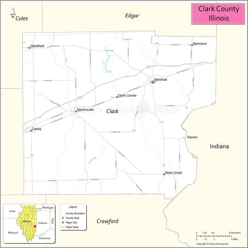
About Clark County Map, Illinois: The map showing the county boundary, county seat, major cities, highways, water bodies and neighbouring counties.
Most Viewed Illinois Links
Clark County, Illinois
Clark County is a county located in the U.S. state of Illinois. It's county seat is Marshall. As per 2020 census, the population of Clark County is 15300 people and population density is square miles. According to the United States Census Bureau, the county has a total area of 501 sq mi (1,298 km2). Clark County was established on 1819.
Facts about Clark County, Illinois
| Country | United States |
| State | Illinois |
| Region | East Central Illinois |
| County Seat | Marshall |
| Named After | George Rogers Clark |
| Established | 1819 |
| Organized | 1819 |
| Coordinates | 39.33° N, 87.79° W |
| Total Area | ~505 sq mi |
| Land Area | ~501 sq mi |
| Water Area | ~4 sq mi |
| Population (2020) | ~15,455 |
| Population Rank | Small-to-mid-sized county in Illinois |
| Largest City | Marshall |
| Main Industries | Agriculture, Manufacturing, Healthcare, Education |
| Major Highway | Interstate 70 |
| Time Zone | Central Time (UTC−06:00) |
| Known For | Wabash River proximity, rural communities, historic Marshall |
| Website | https://www.clarkcountyil.org |
Ctities in Clark county
| City Name | Type | Population (2020) | Pop. Density | Area |
|---|---|---|---|---|
| Marshall | City | 3,947 | 1,076.7/sq mi (415.7/km2) | 3.666 sq mi (9.49 km2) |
| Martinsville | City | 1,118 | 553.2/sq mi (213.6/km2) | 2.021 sq mi (5.23 km2) |
| Westfield | Village | 536 | 548.1/sq mi (211.6/km2) | 0.978 sq mi (2.53 km2) |
| Casey | City | 2,404 | 1,062.3/sq mi (410.2/km2) | 2.263 sq mi (5.86 km2) |
Roads and Highways in Clark County, Illinois
Clark County is served by key highways that connect it to eastern Illinois and nearby Indiana, making regional travel convenient.
- Interstate 70 – runs east-west through the county, connecting Marshall to Terre Haute and Effingham
- U.S. Route 40 – parallels I-70, linking Marshall to Casey and surrounding communities
- Illinois Route 1 – runs north-south, connecting Marshall to Paris and Lawrenceville
- Illinois Route 49 – connects Casey to Marshall through the county
Neighboring Counties of Clark County
- Edgar County (north)
- Vermilion County (northwest)
- Cumberland County (west)
- Jasper County (southwest)
- Crawford County (south)
- Vigo County, Indiana (east)
Top Attractions in Clark County, Illinois
Clark County offers a mix of small-town charm, historic sites, and outdoor spaces along the Illinois-Indiana border.
- Lincoln Trail State Park – A popular destination for camping, fishing, and hiking.
- Marshall Historic Downtown – Features local shops, dining, and historic buildings.
- Clark County Courthouse – A historic landmark located in Marshall.
- Mill Creek Park – Offers trails, picnic areas, and recreational facilities.
- Casey-Westfield Area – Known for nearby attractions and unique roadside art.
- Lincoln Heritage Trail – A scenic route highlighting Abraham Lincoln’s early life travels.
- North Fork Conservation Area – A peaceful spot for nature walks and wildlife viewing.
Distance from Clark County to Nearby Cities
- Marshall to Terre Haute – 10 mi (16 km)
- Marshall to Effingham – 50 mi (80 km)
- Marshall to Champaign – 90 mi (145 km)
- Marshall to Indianapolis – 80 mi (129 km)
- Marshall to St. Louis – 170 mi (274 km)
FAQs about Clark County
Clark County is located in eastern Illinois along the Indiana border, near the city of Terre Haute.
The county is known for its parks, historic sites, and proximity to Indiana and regional travel routes.
Marshall is the county seat and the largest city in Clark County.
Yes, visitors can enjoy state parks, conservation areas, and outdoor recreation such as hiking and fishing.
Clark County is accessible via Interstate 70, U.S. Route 40, and Illinois Routes 1 and 49.
- Adams County Map
- Alexander County Map
- Bond County Map
- Boone County Map
- Brown County Map
- Bureau County Map
- Calhoun County Map
- Carroll County Map
- Cass County Map
- Champaign County Map
- Christian County Map
- Clark County Map
- Clay County Map
- Clinton County Map
- Coles County Map
- Cook County Map
- Crawford County Map
- Cumberland County Map
- DeKalb County Map
- DeWitt County Map
- Douglas County Map
- DuPage County Map
- Edgar County Map
- Edwards County Map
- Effingham County Map
- Fayette County Map
- Ford County Map
- Franklin County Map
- Fulton County Map
- Gallatin County Map
- Greene County Map
- Grundy County Map
- Hamilton County Map
- Hancock County Map
- Hardin County Map
- Henderson County Map
- Henry County Map
- Iroquois County Map
- Jackson County Map
- Jasper County Map
- Jefferson County Map
- Jersey County Map
- Jo Daviess County Map
- Johnson County Map
- Kane County Map
- Kankakee County Map
- Kendall County Map
- Knox County Map
- Lake County Map
- LaSalle County Map
- Lawrence County Map
- Lee County Map
- Livingston County Map
- Logan County Map
- McDonough County Map
- McHenry County Map
- McLean County Map
- Macon County Map
- Macoupin County Map
- Madison County Map
- Marion County Map
- Marshall County Map
- Mason County Map
- Massac County Map
- Menard County Map
- Mercer County Map
- Monroe County Map
- Montgomery County Map
- Morgan County Map
- Moultrie County Map
- Ogle County Map
- Peoria County Map
- Perry County Map
- Piatt County Map
- Pike County Map
- Pope County Map
- Pulaski County Map
- Putnam County Map
- Randolph County Map
- Richland County Map
- Rock Island County Map
- St Clair County Map
- Saline County Map
- Sangamon County Map
- Schuyler County Map
- Scott County Map
- Shelby County Map
- Stark County Map
- Stephenson County Map
- Tazewell County Map
- Union County Map
- Vermilion County Map
- Wabash County Map
- Warren County Map
- Washington County Map
- Wayne County Map
- White County Map
- Whiteside County Map
- Will County Map
- Williamson County Map
- Winnebago County Map
- Woodford County Map
- Alabama Counties
- Alaska boroughs
- Arizona Counties
- Arkansas Counties
- California County Map
- Colorado Counties
- Connecticut Counties
- Delaware Counties
- Florida County Map
- Georgia County Map
- Hawaii Counties
- Idaho Counties
- Illinois Counties
- Indiana Counties
- Iowa Counties
- Kansas Counties
- Kentucky Counties
- Louisiana Counties
- Maine Counties
- Maryland Counties
- Massachusetts Counties
- Michigan County Map
- Minnesota Counties
- Mississippi Counties
- Missouri Counties
- Montana Counties
- Nebraska Counties
- Nevada Counties
- New York Counties
- New Hampshire Counties
- New Jersey Counties
- New Mexico Counties
- North Carolina Counties
- North Dakota Counties
- Ohio County Map
- Oklahoma Counties
- Oregon Counties
- Pennsylvania Counties
- Rhode Island Counties
- South Carolina Counties
- South Dakota Counties
- Map of Tennessee
- Texas County Map
- Utah Counties
- Vermont Counties
- Virginia Counties
- Washington Counties
- West Virginia Counties
- Wisconsin Counties
- Wyoming Counties