Map of Clay County - Clay County is a county located in the U.S. state of Illinois. Clay County Map showing cities, highways, important places and water bodies. Get Where is Clay County located in the map, major cities in Clay county, population, areas, and places of interest.
Clay County Map, Illinois
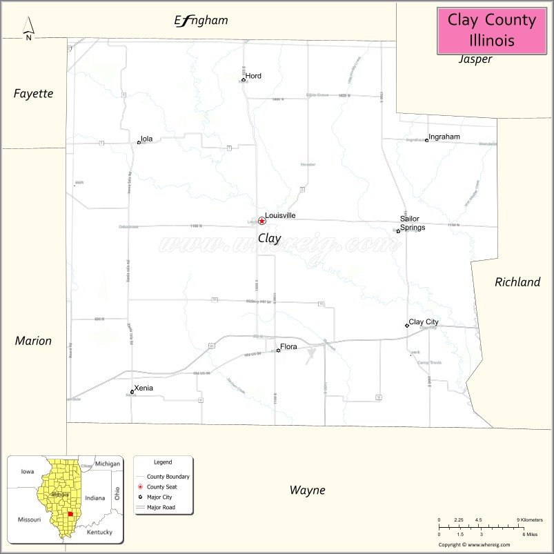
About Clay County Map, Illinois: The map showing the county boundary, county seat, major cities, highways, water bodies and neighbouring counties.
Most Viewed Illinois Links
Clay County, Illinois
Clay County is a county located in the U.S. state of Illinois. It's county seat is Louisville. As per 2020 census, the population of Clay County is 13143 people and population density is square miles. According to the United States Census Bureau, the county has a total area of 468 sq mi (1,212 km2). Clay County was established on 1824.
Facts about Clay County, Illinois
| Country | United States |
| State | Illinois |
| Region | Southeastern Illinois |
| County Seat | Louisville |
| Named After | Henry Clay |
| Established | 1824 |
| Organized | 1824 |
| Coordinates | 38.75° N, 88.49° W |
| Total Area | ~469 sq mi |
| Land Area | ~466 sq mi |
| Water Area | ~3 sq mi |
| Population (2020) | ~13,288 |
| Population Rank | Small-sized county in Illinois |
| Largest City | Flora |
| Main Industries | Agriculture, Manufacturing, Energy, Healthcare |
| Major Highways | Illinois Route 50, Illinois Route 45 |
| Time Zone | Central Time (UTC−06:00) |
| Known For | Rural farmland, oil production history, small-town communities |
| Website | https://www.claycountyillinois.org |
Ctities in Clay county
| City Name | Type | Population (2020) | Pop. Density | Area |
|---|---|---|---|---|
| Clay City | Village | 847 | 475.3/sq mi (183.5/km2) | 1.782 sq mi (4.62 km2) |
| Flora | City | 4,803 | 1,024.1/sq mi (395.4/km2) | 4.69 sq mi (12.15 km2) |
| Iola | Village | 98 | 101.7/sq mi (39.3/km2) | 0.964 sq mi (2.5 km2) |
| Louisville | Village | 1,136 | 1,372.0/sq mi (529.7/km2) | 0.828 sq mi (2.14 km2) |
| Sailor Springs | Village | 89 | 342.3/sq mi (132.2/km2) | 0.26 sq mi (0.67 km2) |
| Xenia | Village | 380 | 770.8/sq mi (297.6/km2) | 0.493 sq mi (1.28 km2) |
Roads and Highways in Clay County, Illinois
Clay County is connected by several state highways that provide access to southeastern Illinois and nearby regional centers.
- U.S. Route 50 – runs east-west through the county, connecting Flora to Olney and Centralia
- Illinois Route 45 – runs north-south, linking Flora to Louisville and Fairfield
- Illinois Route 37 – passes through the county, connecting Salem to Mount Vernon
- Illinois Route 130 – runs north-south along the eastern side, connecting Clay County to Effingham and Olney
Neighboring Counties of Clay County
- Effingham County (north)
- Jasper County (east)
- Richland County (southeast)
- Wayne County (south)
- Marion County (west)
- Fayette County (northwest)
Top Attractions in Clay County, Illinois
Clay County offers a quiet rural setting with local parks, small-town charm, and outdoor recreation opportunities.
- Charley Brown Park – A community park in Flora with playgrounds and open green space.
- Flora Depot Museum – Highlights local railroad history and heritage.
- Clay County Fairgrounds – Hosts the annual fair and community events.
- Flora Community Park – Offers walking paths, sports fields, and picnic areas.
- Charley Brown Memorial Park Lake – A small lake ideal for fishing and relaxing.
- Downtown Flora – Features local shops, dining, and a friendly small-town atmosphere.
- Stephen A. Forbes State Recreation Area (nearby) – Offers camping, boating, and hiking opportunities.
Distance from Clay County to Nearby Cities
- Flora to Effingham – 30 mi (48 km)
- Flora to Centralia – 40 mi (64 km)
- Flora to Mount Vernon – 45 mi (72 km)
- Flora to Springfield – 100 mi (161 km)
- Flora to St. Louis – 120 mi (193 km)
FAQs about Clay County
Clay County is located in southeastern Illinois, surrounded by rural landscapes and small communities.
The county is known for its agricultural setting, small-town charm, and local parks.
Louisville is the county seat, while Flora is the largest city in Clay County.
Yes, visitors can enjoy parks, lakes, and nearby recreation areas for fishing, hiking, and outdoor activities.
Clay County is accessible via U.S. Route 50 and several Illinois state highways including Routes 45, 37, and 130.
- Adams County Map
- Alexander County Map
- Bond County Map
- Boone County Map
- Brown County Map
- Bureau County Map
- Calhoun County Map
- Carroll County Map
- Cass County Map
- Champaign County Map
- Christian County Map
- Clark County Map
- Clay County Map
- Clinton County Map
- Coles County Map
- Cook County Map
- Crawford County Map
- Cumberland County Map
- DeKalb County Map
- DeWitt County Map
- Douglas County Map
- DuPage County Map
- Edgar County Map
- Edwards County Map
- Effingham County Map
- Fayette County Map
- Ford County Map
- Franklin County Map
- Fulton County Map
- Gallatin County Map
- Greene County Map
- Grundy County Map
- Hamilton County Map
- Hancock County Map
- Hardin County Map
- Henderson County Map
- Henry County Map
- Iroquois County Map
- Jackson County Map
- Jasper County Map
- Jefferson County Map
- Jersey County Map
- Jo Daviess County Map
- Johnson County Map
- Kane County Map
- Kankakee County Map
- Kendall County Map
- Knox County Map
- Lake County Map
- LaSalle County Map
- Lawrence County Map
- Lee County Map
- Livingston County Map
- Logan County Map
- McDonough County Map
- McHenry County Map
- McLean County Map
- Macon County Map
- Macoupin County Map
- Madison County Map
- Marion County Map
- Marshall County Map
- Mason County Map
- Massac County Map
- Menard County Map
- Mercer County Map
- Monroe County Map
- Montgomery County Map
- Morgan County Map
- Moultrie County Map
- Ogle County Map
- Peoria County Map
- Perry County Map
- Piatt County Map
- Pike County Map
- Pope County Map
- Pulaski County Map
- Putnam County Map
- Randolph County Map
- Richland County Map
- Rock Island County Map
- St Clair County Map
- Saline County Map
- Sangamon County Map
- Schuyler County Map
- Scott County Map
- Shelby County Map
- Stark County Map
- Stephenson County Map
- Tazewell County Map
- Union County Map
- Vermilion County Map
- Wabash County Map
- Warren County Map
- Washington County Map
- Wayne County Map
- White County Map
- Whiteside County Map
- Will County Map
- Williamson County Map
- Winnebago County Map
- Woodford County Map
- Alabama Counties
- Alaska boroughs
- Arizona Counties
- Arkansas Counties
- California County Map
- Colorado Counties
- Connecticut Counties
- Delaware Counties
- Florida County Map
- Georgia County Map
- Hawaii Counties
- Idaho Counties
- Illinois Counties
- Indiana Counties
- Iowa Counties
- Kansas Counties
- Kentucky Counties
- Louisiana Counties
- Maine Counties
- Maryland Counties
- Massachusetts Counties
- Michigan County Map
- Minnesota Counties
- Mississippi Counties
- Missouri Counties
- Montana Counties
- Nebraska Counties
- Nevada Counties
- New York Counties
- New Hampshire Counties
- New Jersey Counties
- New Mexico Counties
- North Carolina Counties
- North Dakota Counties
- Ohio County Map
- Oklahoma Counties
- Oregon Counties
- Pennsylvania Counties
- Rhode Island Counties
- South Carolina Counties
- South Dakota Counties
- Map of Tennessee
- Texas County Map
- Utah Counties
- Vermont Counties
- Virginia Counties
- Washington Counties
- West Virginia Counties
- Wisconsin Counties
- Wyoming Counties