Map of Jersey County - Jersey County is a county located in the U.S. state of Illinois. Jersey County Map showing cities, highways, important places and water bodies. Get Where is Jersey County located in the map, major cities in Jersey county, population, areas, and places of interest.
Jersey County Map, Illinois
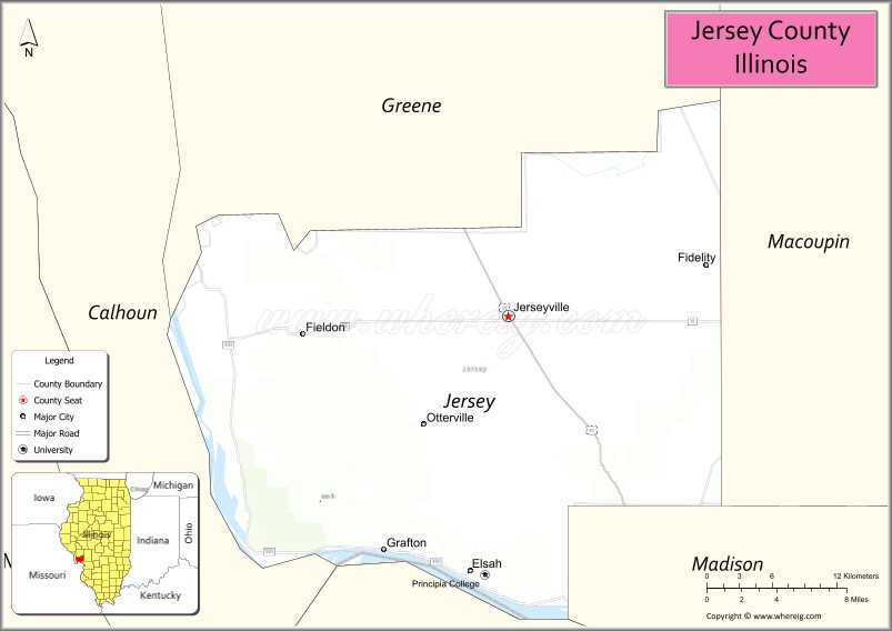
About Jersey County Map, Illinois: The map showing the county boundary, county seat, major cities, highways, water bodies and neighbouring counties.
Most Viewed Illinois Links
Jersey County, Illinois
Jersey County is a county located in the U.S. state of Illinois. It's county seat is Jerseyville. As per 2020 census, the population of Jersey County is 21333 people and population density is square miles. According to the United States Census Bureau, the county has a total area of 369 sq mi (956 km2). Jersey County was established on 1839.
Facts about Jersey County, Illinois
| Country | United States |
| State | Illinois |
| Region | Southwestern Illinois |
| County Seat | Jerseyville |
| Named After | State of New Jersey |
| Established | 1839 |
| Organized | 1839 |
| Coordinates | 39.12° N, 90.36° W |
| Total Area | ~377 sq mi |
| Land Area | ~369 sq mi |
| Water Area | ~8 sq mi |
| Population (2020) | ~21,512 |
| Population Rank | Small-to-mid-sized county in Illinois |
| Largest City | Jerseyville |
| Main Industries | Agriculture, Manufacturing, Healthcare, Retail |
| Major Rivers | Mississippi River, Illinois River |
| Time Zone | Central Time (UTC−06:00) |
| Known For | River bluffs, orchards, proximity to St. Louis metro area |
| Website | https://www.jerseycounty-il.us |
Ctities in Jersey county
| City Name | Type | Population (2020) | Pop. Density | Area |
|---|---|---|---|---|
| Elsah | Village | 519 | 475.3/sq mi (183.5/km2) | 1.092 sq mi (2.83 km2) |
| Fidelity | Village | 96 | 950.5/sq mi (367.0/km2) | 0.101 sq mi (0.26 km2) |
| Fieldon | Village | 176 | 871.3/sq mi (336.4/km2) | 0.202 sq mi (0.52 km2) |
| Grafton | City | 626 | 168.6/sq mi (65.1/km2) | 3.712 sq mi (9.61 km2) |
| Jerseyville | City | 8,337 | 1,591.9/sq mi (614.7/km2) | 5.237 sq mi (13.56 km2) |
| Otterville | Town | 87 | 86.5/sq mi (33.4/km2) | 1.006 sq mi (2.61 km2) |
| Brighton | Village | 2,221 | 1,156.2/sq mi (446.4/km2) | 1.921 sq mi (4.98 km2) |
Roads and Highways in Jersey County, Illinois
Jersey County is connected by key highways that provide access to the Mississippi River region and nearby St. Louis metro area.
- Illinois Route 16 – runs east-west through the county, connecting Jerseyville to Carrollton and Litchfield
- Illinois Route 3 – runs north-south along the western side, linking Grafton to Alton and Chester
- Illinois Route 100 – follows the Illinois River, connecting scenic river towns like Grafton to nearby areas
- Illinois Route 109 – runs east-west, linking Jerseyville to Alton and surrounding communities
Neighboring Counties of Jersey County
- Greene County (north)
- Macoupin County (east)
- Madison County (south)
- Calhoun County (west)
Top Attractions in Jersey County, Illinois
Jersey County offers scenic river views, outdoor recreation, and small-town charm near the confluence of the Illinois and Mississippi Rivers.
- Pere Marquette State Park – A popular destination for hiking, scenic overlooks, and wildlife viewing.
- Grafton Riverfront – A lively area with restaurants, shops, and river views.
- Illinois River Road National Scenic Byway – A scenic drive with beautiful landscapes and historic sites.
- Raging Rivers WaterPark – A family-friendly attraction with slides and pools.
- Jersey County Courthouse – A historic landmark in Jerseyville.
- Grafton SkyTour – Offers aerial views of the river and surrounding countryside.
- Downtown Jerseyville – Features local shops, dining, and community events.
Distance from Jersey County to Nearby Cities
- Jerseyville to St. Louis – 45 mi (72 km)
- Jerseyville to Alton – 20 mi (32 km)
- Jerseyville to Springfield – 75 mi (121 km)
- Jerseyville to Edwardsville – 30 mi (48 km)
- Jerseyville to Quincy – 120 mi (193 km)
FAQs about Jersey County
Jersey County is located in southwestern Illinois, near the confluence of the Illinois and Mississippi Rivers.
The county is known for Pere Marquette State Park, scenic river views, and outdoor recreation.
Jerseyville is the county seat and the largest city in Jersey County.
Yes, visitors can enjoy hiking, scenic drives, river activities, and parks throughout the county.
Jersey County is accessible via Illinois Routes 16, 3, 100, and 109, with easy access to the St. Louis area.
- Adams County Map
- Alexander County Map
- Bond County Map
- Boone County Map
- Brown County Map
- Bureau County Map
- Calhoun County Map
- Carroll County Map
- Cass County Map
- Champaign County Map
- Christian County Map
- Clark County Map
- Clay County Map
- Clinton County Map
- Coles County Map
- Cook County Map
- Crawford County Map
- Cumberland County Map
- DeKalb County Map
- DeWitt County Map
- Douglas County Map
- DuPage County Map
- Edgar County Map
- Edwards County Map
- Effingham County Map
- Fayette County Map
- Ford County Map
- Franklin County Map
- Fulton County Map
- Gallatin County Map
- Greene County Map
- Grundy County Map
- Hamilton County Map
- Hancock County Map
- Hardin County Map
- Henderson County Map
- Henry County Map
- Iroquois County Map
- Jackson County Map
- Jasper County Map
- Jefferson County Map
- Jersey County Map
- Jo Daviess County Map
- Johnson County Map
- Kane County Map
- Kankakee County Map
- Kendall County Map
- Knox County Map
- Lake County Map
- LaSalle County Map
- Lawrence County Map
- Lee County Map
- Livingston County Map
- Logan County Map
- McDonough County Map
- McHenry County Map
- McLean County Map
- Macon County Map
- Macoupin County Map
- Madison County Map
- Marion County Map
- Marshall County Map
- Mason County Map
- Massac County Map
- Menard County Map
- Mercer County Map
- Monroe County Map
- Montgomery County Map
- Morgan County Map
- Moultrie County Map
- Ogle County Map
- Peoria County Map
- Perry County Map
- Piatt County Map
- Pike County Map
- Pope County Map
- Pulaski County Map
- Putnam County Map
- Randolph County Map
- Richland County Map
- Rock Island County Map
- St Clair County Map
- Saline County Map
- Sangamon County Map
- Schuyler County Map
- Scott County Map
- Shelby County Map
- Stark County Map
- Stephenson County Map
- Tazewell County Map
- Union County Map
- Vermilion County Map
- Wabash County Map
- Warren County Map
- Washington County Map
- Wayne County Map
- White County Map
- Whiteside County Map
- Will County Map
- Williamson County Map
- Winnebago County Map
- Woodford County Map
- Alabama Counties
- Alaska boroughs
- Arizona Counties
- Arkansas Counties
- California County Map
- Colorado Counties
- Connecticut Counties
- Delaware Counties
- Florida County Map
- Georgia County Map
- Hawaii Counties
- Idaho Counties
- Illinois Counties
- Indiana Counties
- Iowa Counties
- Kansas Counties
- Kentucky Counties
- Louisiana Counties
- Maine Counties
- Maryland Counties
- Massachusetts Counties
- Michigan County Map
- Minnesota Counties
- Mississippi Counties
- Missouri Counties
- Montana Counties
- Nebraska Counties
- Nevada Counties
- New York Counties
- New Hampshire Counties
- New Jersey Counties
- New Mexico Counties
- North Carolina Counties
- North Dakota Counties
- Ohio County Map
- Oklahoma Counties
- Oregon Counties
- Pennsylvania Counties
- Rhode Island Counties
- South Carolina Counties
- South Dakota Counties
- Map of Tennessee
- Texas County Map
- Utah Counties
- Vermont Counties
- Virginia Counties
- Washington Counties
- West Virginia Counties
- Wisconsin Counties
- Wyoming Counties