Map of Jefferson County - Jefferson County is a county located in the U.S. state of Illinois. Jefferson County Map showing cities, highways, important places and water bodies. Get Where is Jefferson County located in the map, major cities in Jefferson county, population, areas, and places of interest.
Jefferson County Map, Illinois
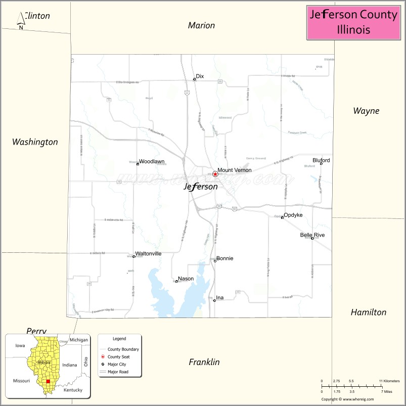
About Jefferson County Map, Illinois: The map showing the county boundary, county seat, major cities, highways, water bodies and neighbouring counties.
Most Viewed Illinois Links
Jefferson County, Illinois
Jefferson County is a county located in the U.S. state of Illinois. It's county seat is Mount Vernon. As per 2020 census, the population of Jefferson County is 36877 people and population density is square miles. According to the United States Census Bureau, the county has a total area of 571 sq mi (1,479 km2). Jefferson County was established on 1819.
Facts about Jefferson County, Illinois
| Country | United States |
| State | Illinois |
| Region | Southern Illinois |
| County Seat | Mount Vernon |
| Named After | Thomas Jefferson |
| Established | 1819 |
| Organized | 1819 |
| Coordinates | 38.30° N, 88.92° W |
| Total Area | ~572 sq mi |
| Land Area | ~571 sq mi |
| Water Area | ~1 sq mi |
| Population (2020) | ~38,827 |
| Population Rank | Mid-sized county in Illinois |
| Largest City | Mount Vernon |
| Main Industries | Healthcare, Manufacturing, Retail, Transportation |
| Major Highways | Interstate 57, Interstate 64 |
| Time Zone | Central Time (UTC−06:00) |
| Known For | Transportation crossroads, healthcare hub, nearby Rend Lake recreation |
| Website | https://www.jeffersoncountyillinois.com |
Ctities in Jefferson county
| City Name | Type | Population (2020) | Pop. Density | Area |
|---|---|---|---|---|
| Belle Rive | Village | 309 | 301.2/sq mi (116.3/km2) | 1.026 sq mi (2.66 km2) |
| Bluford | Village | 630 | 403.6/sq mi (155.8/km2) | 1.561 sq mi (4.04 km2) |
| Bonnie | Village | 374 | 293.3/sq mi (113.3/km2) | 1.275 sq mi (3.3 km2) |
| Dix | Village | 469 | 226.1/sq mi (87.3/km2) | 2.074 sq mi (5.37 km2) |
| Ina | Village | 1,641 | 682.3/sq mi (263.4/km2) | 2.405 sq mi (6.23 km2) |
| Mount Vernon | City | 14,600 | 1,001.2/sq mi (386.6/km2) | 14.583 sq mi (37.77 km2) |
| Nason | City | 199 | 218.4/sq mi (84.3/km2) | 0.911 sq mi (2.36 km2) |
| Waltonville | Village | 408 | 329.0/sq mi (127.0/km2) | 1.24 sq mi (3.21 km2) |
| Woodlawn | Village | 617 | 724.2/sq mi (279.6/km2) | 0.852 sq mi (2.21 km2) |
| Centralia | City | 12,182 | 1,485.6/sq mi (573.6/km2) | 8.2 sq mi (21.24 km2) |
Roads and Highways in Jefferson County, Illinois
Jefferson County is well-connected by major highways that provide easy access to southern Illinois and regional transportation routes.
- Interstate 57 – runs north-south through the county, connecting Mount Vernon to Marion and Effingham
- Interstate 64 – runs east-west through the county, linking Mount Vernon to St. Louis and Evansville
- U.S. Route 51 – runs north-south, connecting Mount Vernon to Centralia and Marion
- Illinois Route 15 – runs east-west, linking Mount Vernon to Fairfield and Nashville
- Illinois Route 37 – runs north-south, connecting Mount Vernon to Salem and Benton
Neighboring Counties of Jefferson County
- Marion County (north)
- Wayne County (east)
- Hamilton County (southeast)
- Franklin County (south)
- Perry County (west)
- Washington County (northwest)
Top Attractions in Jefferson County, Illinois
Jefferson County offers a mix of outdoor recreation, local history, and community attractions centered around Mount Vernon.
- Cedarhurst Center for the Arts – A major cultural destination with galleries, sculptures, and events.
- Rend Lake (nearby) – A popular spot for boating, fishing, camping, and outdoor recreation.
- Jefferson County Historical Village – Showcases historic buildings and local heritage.
- Veterans Memorial Park – A peaceful park honoring military service members.
- Mount Vernon Downtown Area – Features shops, dining, and community events.
- Lincoln Park – A local park with trails, playgrounds, and picnic areas.
- King City Square Shopping Area – A regional shopping and dining destination.
Distance from Jefferson County to Nearby Cities
- Mount Vernon to Marion – 25 mi (40 km)
- Mount Vernon to Carbondale – 50 mi (80 km)
- Mount Vernon to Evansville – 80 mi (129 km)
- Mount Vernon to St. Louis – 80 mi (129 km)
- Mount Vernon to Effingham – 60 mi (97 km)
FAQs about Jefferson County
Jefferson County is located in southern Illinois, centered around the city of Mount Vernon.
The county is known for its highway crossroads, cultural attractions, and nearby outdoor recreation areas.
Mount Vernon is the county seat and the largest city in Jefferson County.
Yes, visitors can enjoy parks, lakes, trails, and recreational areas throughout the county.
Jefferson County is accessible via Interstates 57 and 64, along with several U.S. and state highways.
- Adams County Map
- Alexander County Map
- Bond County Map
- Boone County Map
- Brown County Map
- Bureau County Map
- Calhoun County Map
- Carroll County Map
- Cass County Map
- Champaign County Map
- Christian County Map
- Clark County Map
- Clay County Map
- Clinton County Map
- Coles County Map
- Cook County Map
- Crawford County Map
- Cumberland County Map
- DeKalb County Map
- DeWitt County Map
- Douglas County Map
- DuPage County Map
- Edgar County Map
- Edwards County Map
- Effingham County Map
- Fayette County Map
- Ford County Map
- Franklin County Map
- Fulton County Map
- Gallatin County Map
- Greene County Map
- Grundy County Map
- Hamilton County Map
- Hancock County Map
- Hardin County Map
- Henderson County Map
- Henry County Map
- Iroquois County Map
- Jackson County Map
- Jasper County Map
- Jefferson County Map
- Jersey County Map
- Jo Daviess County Map
- Johnson County Map
- Kane County Map
- Kankakee County Map
- Kendall County Map
- Knox County Map
- Lake County Map
- LaSalle County Map
- Lawrence County Map
- Lee County Map
- Livingston County Map
- Logan County Map
- McDonough County Map
- McHenry County Map
- McLean County Map
- Macon County Map
- Macoupin County Map
- Madison County Map
- Marion County Map
- Marshall County Map
- Mason County Map
- Massac County Map
- Menard County Map
- Mercer County Map
- Monroe County Map
- Montgomery County Map
- Morgan County Map
- Moultrie County Map
- Ogle County Map
- Peoria County Map
- Perry County Map
- Piatt County Map
- Pike County Map
- Pope County Map
- Pulaski County Map
- Putnam County Map
- Randolph County Map
- Richland County Map
- Rock Island County Map
- St Clair County Map
- Saline County Map
- Sangamon County Map
- Schuyler County Map
- Scott County Map
- Shelby County Map
- Stark County Map
- Stephenson County Map
- Tazewell County Map
- Union County Map
- Vermilion County Map
- Wabash County Map
- Warren County Map
- Washington County Map
- Wayne County Map
- White County Map
- Whiteside County Map
- Will County Map
- Williamson County Map
- Winnebago County Map
- Woodford County Map
- Alabama Counties
- Alaska boroughs
- Arizona Counties
- Arkansas Counties
- California County Map
- Colorado Counties
- Connecticut Counties
- Delaware Counties
- Florida County Map
- Georgia County Map
- Hawaii Counties
- Idaho Counties
- Illinois Counties
- Indiana Counties
- Iowa Counties
- Kansas Counties
- Kentucky Counties
- Louisiana Counties
- Maine Counties
- Maryland Counties
- Massachusetts Counties
- Michigan County Map
- Minnesota Counties
- Mississippi Counties
- Missouri Counties
- Montana Counties
- Nebraska Counties
- Nevada Counties
- New York Counties
- New Hampshire Counties
- New Jersey Counties
- New Mexico Counties
- North Carolina Counties
- North Dakota Counties
- Ohio County Map
- Oklahoma Counties
- Oregon Counties
- Pennsylvania Counties
- Rhode Island Counties
- South Carolina Counties
- South Dakota Counties
- Map of Tennessee
- Texas County Map
- Utah Counties
- Vermont Counties
- Virginia Counties
- Washington Counties
- West Virginia Counties
- Wisconsin Counties
- Wyoming Counties