Map of Perry County - Perry County is a county located in the U.S. state of Illinois. Perry County Map showing cities, highways, important places and water bodies. Get Where is Perry County located in the map, major cities in Perry county, population, areas, and places of interest.
Perry County Map, Illinois
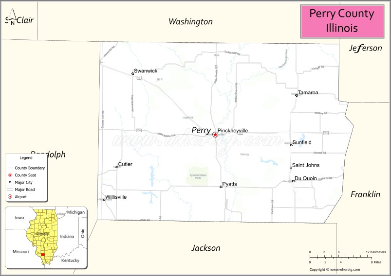
About Perry County Map, Illinois: The map showing the county boundary, county seat, major cities, highways, water bodies and neighbouring counties.
Most Viewed Illinois Links
Perry County, Illinois
Perry County is a county located in the U.S. state of Illinois. It's county seat is Pinckneyville. As per 2020 census, the population of Perry County is 20985 people and population density is square miles. According to the United States Census Bureau, the county has a total area of 441 sq mi (1,142 km2). Perry County was established on 1827.
Facts about Perry County, Illinois
| Country | United States |
| State | Illinois |
| Region | Southern Illinois |
| County Seat | Pinckneyville |
| Named After | Commodore Oliver Hazard Perry |
| Established | 1827 |
| Organized | 1827 |
| Coordinates | 38.08° N, 89.38° W |
| Total Area | ~442 sq mi |
| Land Area | ~441 sq mi |
| Water Area | ~1 sq mi |
| Population (2020) | ~21,650 |
| Population Rank | Small to mid-sized county in Illinois |
| Largest City | Pinckneyville |
| Main Industries | Agriculture, Manufacturing, Energy, Healthcare |
| Major Highways | Illinois Route 13, Illinois Route 127 |
| Time Zone | Central Time (UTC−06:00) |
| Known For | Coal mining heritage, rural communities, Pinckneyville DuQuoin area |
| Website | https://www.perrycountyil.gov |
Ctities in Perry county
| City Name | Type | Population (2020) | Pop. Density | Area |
|---|---|---|---|---|
| Cutler | Village | 361 | 771.4/sq mi (297.8/km2) | 0.468 sq mi (1.21 km2) |
| Du Quoin | City | 5,827 | 834.9/sq mi (322.4/km2) | 6.979 sq mi (18.08 km2) |
| Pinckneyville | City | 5,066 | 1,233.8/sq mi (476.4/km2) | 4.106 sq mi (10.63 km2) |
| St. Johns | Village | 163 | 224.8/sq mi (86.8/km2) | 0.725 sq mi (1.88 km2) |
| Tamaroa | Village | 544 | 567.8/sq mi (219.2/km2) | 0.958 sq mi (2.48 km2) |
| Willisville | Village | 579 | 1,488.4/sq mi (574.7/km2) | 0.389 sq mi (1.01 km2) |
Roads and Highways in Perry County, Illinois
Perry County is served by key highways that provide access to southern Illinois and surrounding regions.
- Illinois Route 13 – runs east-west through the county, connecting Du Quoin to Carbondale and Marion
- Illinois Route 127 – runs north-south, linking Pinckneyville to Murphysboro and Nashville
- Illinois Route 154 – runs east-west, connecting Pinckneyville to Sparta and Sesser
- Illinois Route 152 – serves local communities, linking Du Quoin to surrounding rural areas
Neighboring Counties of Perry County
- Washington County (north)
- Jefferson County (east)
- Franklin County (southeast)
- Jackson County (southwest)
- Randolph County (west)
Top Attractions in Perry County, Illinois
Perry County offers a mix of outdoor recreation, local history, and small-town charm.
- Du Quoin State Fairgrounds – Hosts the annual Illinois State Fair and major events.
- Pyramid State Recreation Area – One of the largest state recreation areas with lakes and trails.
- Pinckneyville Downtown Area – Features shops, dining, and historic buildings.
- Perry County Courthouse – A historic landmark located in Pinckneyville.
- Du Quoin City Lake – Offers fishing, boating, and outdoor recreation.
- Pinckneyville Fairgrounds – Hosts local fairs and community events.
- Southwestern Illinois College (Du Quoin campus) – Provides educational and community programs.
Distance from Perry County to Nearby Cities
- Pinckneyville to Carbondale – 35 mi (56 km)
- Du Quoin to St. Louis – 80 mi (129 km)
- Pinckneyville to Marion – 30 mi (48 km)
- Du Quoin to Mount Vernon – 45 mi (72 km)
- Pinckneyville to Springfield – 100 mi (161 km)
FAQs about Perry County
Perry County is located in southern Illinois, centered around the communities of Pinckneyville and Du Quoin.
The county is known for the Du Quoin State Fair, recreation areas, and outdoor activities.
Pinckneyville is the county seat and a central city in Perry County.
Yes, visitors can enjoy lakes, parks, trails, and outdoor recreation throughout the county.
Perry County is accessible via Illinois Routes 13, 127, and 154.
- Adams County Map
- Alexander County Map
- Bond County Map
- Boone County Map
- Brown County Map
- Bureau County Map
- Calhoun County Map
- Carroll County Map
- Cass County Map
- Champaign County Map
- Christian County Map
- Clark County Map
- Clay County Map
- Clinton County Map
- Coles County Map
- Cook County Map
- Crawford County Map
- Cumberland County Map
- DeKalb County Map
- DeWitt County Map
- Douglas County Map
- DuPage County Map
- Edgar County Map
- Edwards County Map
- Effingham County Map
- Fayette County Map
- Ford County Map
- Franklin County Map
- Fulton County Map
- Gallatin County Map
- Greene County Map
- Grundy County Map
- Hamilton County Map
- Hancock County Map
- Hardin County Map
- Henderson County Map
- Henry County Map
- Iroquois County Map
- Jackson County Map
- Jasper County Map
- Jefferson County Map
- Jersey County Map
- Jo Daviess County Map
- Johnson County Map
- Kane County Map
- Kankakee County Map
- Kendall County Map
- Knox County Map
- Lake County Map
- LaSalle County Map
- Lawrence County Map
- Lee County Map
- Livingston County Map
- Logan County Map
- McDonough County Map
- McHenry County Map
- McLean County Map
- Macon County Map
- Macoupin County Map
- Madison County Map
- Marion County Map
- Marshall County Map
- Mason County Map
- Massac County Map
- Menard County Map
- Mercer County Map
- Monroe County Map
- Montgomery County Map
- Morgan County Map
- Moultrie County Map
- Ogle County Map
- Peoria County Map
- Perry County Map
- Piatt County Map
- Pike County Map
- Pope County Map
- Pulaski County Map
- Putnam County Map
- Randolph County Map
- Richland County Map
- Rock Island County Map
- St Clair County Map
- Saline County Map
- Sangamon County Map
- Schuyler County Map
- Scott County Map
- Shelby County Map
- Stark County Map
- Stephenson County Map
- Tazewell County Map
- Union County Map
- Vermilion County Map
- Wabash County Map
- Warren County Map
- Washington County Map
- Wayne County Map
- White County Map
- Whiteside County Map
- Will County Map
- Williamson County Map
- Winnebago County Map
- Woodford County Map
- Alabama Counties
- Alaska boroughs
- Arizona Counties
- Arkansas Counties
- California County Map
- Colorado Counties
- Connecticut Counties
- Delaware Counties
- Florida County Map
- Georgia County Map
- Hawaii Counties
- Idaho Counties
- Illinois Counties
- Indiana Counties
- Iowa Counties
- Kansas Counties
- Kentucky Counties
- Louisiana Counties
- Maine Counties
- Maryland Counties
- Massachusetts Counties
- Michigan County Map
- Minnesota Counties
- Mississippi Counties
- Missouri Counties
- Montana Counties
- Nebraska Counties
- Nevada Counties
- New York Counties
- New Hampshire Counties
- New Jersey Counties
- New Mexico Counties
- North Carolina Counties
- North Dakota Counties
- Ohio County Map
- Oklahoma Counties
- Oregon Counties
- Pennsylvania Counties
- Rhode Island Counties
- South Carolina Counties
- South Dakota Counties
- Map of Tennessee
- Texas County Map
- Utah Counties
- Vermont Counties
- Virginia Counties
- Washington Counties
- West Virginia Counties
- Wisconsin Counties
- Wyoming Counties