Map of Hancock County - Hancock County is a county located in the U.S. state of Illinois. Hancock County Map showing cities, highways, important places and water bodies. Get Where is Hancock County located in the map, major cities in Hancock county, population, areas, and places of interest.
Hancock County Map, Illinois
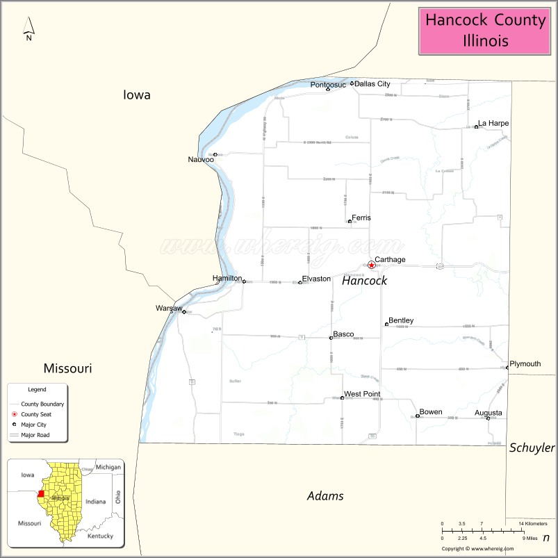
About Hancock County Map, Illinois: The map showing the county boundary, county seat, major cities, highways, water bodies and neighbouring counties.
Most Viewed Illinois Links
Hancock County, Illinois
Hancock County is a county located in the U.S. state of Illinois. It's county seat is Carthage. As per 2020 census, the population of Hancock County is 17400 people and population density is square miles. According to the United States Census Bureau, the county has a total area of 793 sq mi (2,054 km2). Hancock County was established on 1825.
Facts about Hancock County, Illinois
| Country | United States |
| State | Illinois |
| Region | Western Illinois |
| County Seat | Carthage |
| Named After | John Hancock |
| Established | 1825 |
| Organized | 1825 |
| Coordinates | 40.40° N, 91.17° W |
| Total Area | ~794 sq mi |
| Land Area | ~794 sq mi |
| Water Area | ~0.4 sq mi |
| Population (2020) | ~17,097 |
| Population Rank | Small-to-mid-sized county in Illinois |
| Largest City | Carthage |
| Main Industries | Agriculture, Manufacturing, Healthcare, Education |
| Major Highway | Illinois Route 96 |
| Time Zone | Central Time (UTC−06:00) |
| Known For | Nauvoo Historic District nearby, Mississippi River access, rural heritage |
| Website | https://www.hancockcountyil.gov |
Ctities in Hancock county
| City Name | Type | Population (2020) | Pop. Density | Area |
|---|---|---|---|---|
| Augusta | Village | 553 | 800.3/sq mi (309.0/km2) | 0.691 sq mi (1.79 km2) |
| Basco | Village | 80 | 360.4/sq mi (139.1/km2) | 0.222 sq mi (0.57 km2) |
| Bentley | Town | 30 | 209.8/sq mi (81.0/km2) | 0.143 sq mi (0.37 km2) |
| Bowen | Village | 464 | 1,084.1/sq mi (418.6/km2) | 0.428 sq mi (1.11 km2) |
| Carthage | City | 2,490 | 999.6/sq mi (385.9/km2) | 2.491 sq mi (6.45 km2) |
| Elvaston | Village | 147 | 184.0/sq mi (71.0/km2) | 0.799 sq mi (2.07 km2) |
| Ferris | Village | 127 | 64.6/sq mi (24.9/km2) | 1.967 sq mi (5.09 km2) |
| Hamilton | City | 2,753 | 773.1/sq mi (298.5/km2) | 3.561 sq mi (9.22 km2) |
| La Harpe | City | 1,175 | 861.4/sq mi (332.6/km2) | 1.364 sq mi (3.53 km2) |
| Nauvoo | City | 950 | 280.6/sq mi (108.3/km2) | 3.386 sq mi (8.77 km2) |
| Plymouth | Village | 436 | 771.7/sq mi (297.9/km2) | 0.565 sq mi (1.46 km2) |
| Pontoosuc | Village | 99 | 70.4/sq mi (27.2/km2) | 1.406 sq mi (3.64 km2) |
| Warsaw | City | 1,510 | 231.6/sq mi (89.4/km2) | 6.52 sq mi (16.89 km2) |
| West Point | Village | 140 | 833.3/sq mi (321.8/km2) | 0.168 sq mi (0.44 km2) |
| Dallas City | City | 805 | 339.1/sq mi (130.9/km2) | 2.374 sq mi (6.15 km2) |
Roads and Highways in Hancock County, Illinois
Hancock County is served by several key highways that connect it to western Illinois and the Mississippi River region.
- U.S. Route 136 – runs east-west through the county, connecting Carthage to Macomb and Keokuk, Iowa
- Illinois Route 96 – runs north-south along the Mississippi River, linking Nauvoo to Hamilton and Quincy
- Illinois Route 9 – crosses the northern part of the county, connecting Dallas City to Blandinsville
- Illinois Route 94 – runs north-south, connecting Carthage to Bowen and La Harpe
Neighboring Counties of Hancock County
- McDonough County (east)
- Schuyler County (southeast)
- Adams County (south)
- Lee County, Iowa (west)
- Des Moines County, Iowa (northwest)
Top Attractions in Hancock County, Illinois
Hancock County offers scenic river views, historic landmarks, and small-town charm along the Mississippi River.
- Nauvoo Historic District – A major historic site with restored buildings and cultural attractions.
- Carthage Jail – A historic site associated with early Mormon history.
- Mississippi Riverfront Parks – Provide scenic views, walking paths, and picnic areas.
- Hancock County Courthouse – A historic landmark located in Carthage.
- Hamilton Riverfront Park – A relaxing area along the Mississippi River.
- Rheinberger House Museum – Showcases local history and heritage.
- Downtown Carthage Square – Features shops, dining, and historic architecture.
Distance from Hancock County to Nearby Cities
- Carthage to Quincy – 30 mi (48 km)
- Carthage to Macomb – 25 mi (40 km)
- Carthage to Burlington – 40 mi (64 km)
- Carthage to Springfield – 100 mi (161 km)
- Carthage to Peoria – 110 mi (177 km)
FAQs about Hancock County
Hancock County is located in western Illinois along the Mississippi River, bordering Iowa.
The county is known for Nauvoo’s historic sites, riverfront views, and its small-town communities.
Carthage is the county seat and the largest city in Hancock County.
Yes, visitors can enjoy riverfront parks, walking trails, and outdoor recreation along the Mississippi River.
Hancock County is accessible via U.S. Route 136 and several Illinois state highways including Routes 9, 94, and 96.
- Adams County Map
- Alexander County Map
- Bond County Map
- Boone County Map
- Brown County Map
- Bureau County Map
- Calhoun County Map
- Carroll County Map
- Cass County Map
- Champaign County Map
- Christian County Map
- Clark County Map
- Clay County Map
- Clinton County Map
- Coles County Map
- Cook County Map
- Crawford County Map
- Cumberland County Map
- DeKalb County Map
- DeWitt County Map
- Douglas County Map
- DuPage County Map
- Edgar County Map
- Edwards County Map
- Effingham County Map
- Fayette County Map
- Ford County Map
- Franklin County Map
- Fulton County Map
- Gallatin County Map
- Greene County Map
- Grundy County Map
- Hamilton County Map
- Hancock County Map
- Hardin County Map
- Henderson County Map
- Henry County Map
- Iroquois County Map
- Jackson County Map
- Jasper County Map
- Jefferson County Map
- Jersey County Map
- Jo Daviess County Map
- Johnson County Map
- Kane County Map
- Kankakee County Map
- Kendall County Map
- Knox County Map
- Lake County Map
- LaSalle County Map
- Lawrence County Map
- Lee County Map
- Livingston County Map
- Logan County Map
- McDonough County Map
- McHenry County Map
- McLean County Map
- Macon County Map
- Macoupin County Map
- Madison County Map
- Marion County Map
- Marshall County Map
- Mason County Map
- Massac County Map
- Menard County Map
- Mercer County Map
- Monroe County Map
- Montgomery County Map
- Morgan County Map
- Moultrie County Map
- Ogle County Map
- Peoria County Map
- Perry County Map
- Piatt County Map
- Pike County Map
- Pope County Map
- Pulaski County Map
- Putnam County Map
- Randolph County Map
- Richland County Map
- Rock Island County Map
- St Clair County Map
- Saline County Map
- Sangamon County Map
- Schuyler County Map
- Scott County Map
- Shelby County Map
- Stark County Map
- Stephenson County Map
- Tazewell County Map
- Union County Map
- Vermilion County Map
- Wabash County Map
- Warren County Map
- Washington County Map
- Wayne County Map
- White County Map
- Whiteside County Map
- Will County Map
- Williamson County Map
- Winnebago County Map
- Woodford County Map
- Alabama Counties
- Alaska boroughs
- Arizona Counties
- Arkansas Counties
- California County Map
- Colorado Counties
- Connecticut Counties
- Delaware Counties
- Florida County Map
- Georgia County Map
- Hawaii Counties
- Idaho Counties
- Illinois Counties
- Indiana Counties
- Iowa Counties
- Kansas Counties
- Kentucky Counties
- Louisiana Counties
- Maine Counties
- Maryland Counties
- Massachusetts Counties
- Michigan County Map
- Minnesota Counties
- Mississippi Counties
- Missouri Counties
- Montana Counties
- Nebraska Counties
- Nevada Counties
- New York Counties
- New Hampshire Counties
- New Jersey Counties
- New Mexico Counties
- North Carolina Counties
- North Dakota Counties
- Ohio County Map
- Oklahoma Counties
- Oregon Counties
- Pennsylvania Counties
- Rhode Island Counties
- South Carolina Counties
- South Dakota Counties
- Map of Tennessee
- Texas County Map
- Utah Counties
- Vermont Counties
- Virginia Counties
- Washington Counties
- West Virginia Counties
- Wisconsin Counties
- Wyoming Counties