Map of Marion County - Marion County is a county located in the U.S. state of Illinois. Marion County Map showing cities, highways, important places and water bodies. Get Where is Marion County located in the map, major cities in Marion county, population, areas, and places of interest.
Macon County Map, Illinois
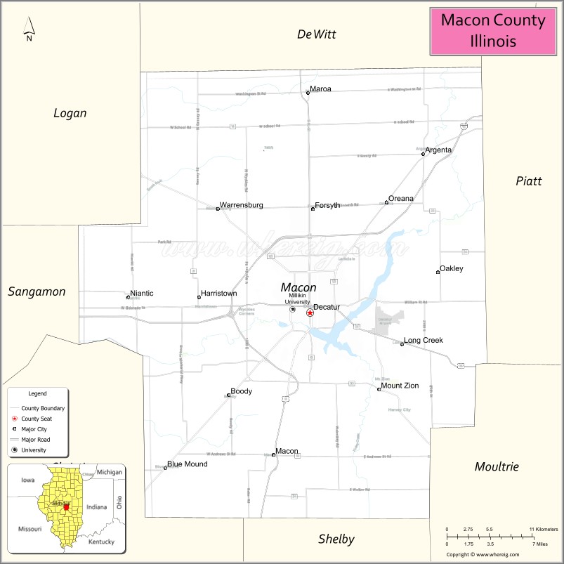
About Marion County Map, Illinois: The map showing the county boundary, county seat, major cities, highways, water bodies and neighbouring counties.
Most Viewed Illinois Links
Macon County, Illinois
Macon County is a county located in the U.S. state of Illinois. It's county seat is Decatur. As per 2020 census, the population of Macon County is 102432 people and population density is square miles. According to the United States Census Bureau, the county has a total area of 580 sq mi (1,502 km2). Macon County was established on 1829.
Facts about Macon County, Illinois
| Country | United States |
| State | Illinois |
| Region | Central Illinois |
| County Seat | Decatur |
| Named After | Nathaniel Macon |
| Established | 1829 |
| Organized | 1829 |
| Coordinates | 39.86° N, 88.96° W |
| Total Area | ~581 sq mi |
| Land Area | ~581 sq mi |
| Water Area | ~1 sq mi |
| Population (2020) | ~103,998 |
| Population Rank | One of the more populous counties in Illinois |
| Largest City | Decatur |
| Main Industries | Manufacturing, Agriculture, Healthcare, Energy |
| Major Highways | Interstate 72, U.S. Route 51 |
| Time Zone | Central Time (UTC−06:00) |
| Known For | Agribusiness hub, manufacturing base, Lake Decatur |
| Website | https://www.macoupincountyil.gov |
Ctities in Macon county
| City Name | Type | Population (2020) | Pop. Density | Area |
|---|---|---|---|---|
| Argenta | Village | 913 | 1,398.2/sq mi (539.8/km2) | 0.653 sq mi (1.69 km2) |
| Blue Mound | Village | 1,133 | 1,936.8/sq mi (747.8/km2) | 0.585 sq mi (1.52 km2) |
| Decatur | City | 70,522 | 1,644.1/sq mi (634.8/km2) | 42.894 sq mi (111.09 km2) |
| Forsyth | Village | 3,734 | 1,193.0/sq mi (460.6/km2) | 3.13 sq mi (8.11 km2) |
| Harristown | Village | 1,310 | 729.0/sq mi (281.5/km2) | 1.797 sq mi (4.65 km2) |
| Long Creek | Village | 1,261 | 446.4/sq mi (172.3/km2) | 2.825 sq mi (7.32 km2) |
| Macon | City | 1,177 | 811.2/sq mi (313.2/km2) | 1.451 sq mi (3.76 km2) |
| Maroa | City | 1,577 | 894.5/sq mi (345.4/km2) | 1.763 sq mi (4.57 km2) |
| Mount Zion | Village | 6,019 | 1,423.9/sq mi (549.8/km2) | 4.227 sq mi (10.95 km2) |
| Niantic | Village | 612 | 589.0/sq mi (227.4/km2) | 1.039 sq mi (2.69 km2) |
| Oreana | Village | 891 | 1,903.8/sq mi (735.1/km2) | 0.468 sq mi (1.21 km2) |
| Warrensburg | Village | 1,110 | 1,524.7/sq mi (588.7/km2) | 0.728 sq mi (1.89 km2) |
Roads and Highways in Macon County, Illinois
Macon County is a major transportation hub in central Illinois with several highways connecting it to surrounding regions.
- Interstate 72 – runs east-west through the county, connecting Decatur to Springfield and Champaign
- U.S. Route 51 – runs north-south, linking Decatur to Bloomington and Pana
- Illinois Route 48 – runs north-south, connecting Decatur to Taylorville and Clinton
- Illinois Route 121 – runs north-south, linking Decatur to Lincoln and Mattoon
- Illinois Route 105 – runs east-west, connecting Decatur to Bement and Cerro Gordo
Neighboring Counties of Macon County
- DeWitt County (north)
- Piatt County (northeast)
- Moultrie County (east)
- Shelby County (south)
- Christian County (southwest)
- Sangamon County (west)
Top Attractions in Macon County, Illinois
Macon County offers a mix of parks, cultural attractions, and historic sites centered around the city of Decatur.
- Scovill Zoo – A family-friendly attraction with a variety of animals and exhibits.
- Rock Springs Conservation Area – Offers trails, lakes, and nature education programs.
- Children’s Museum of Illinois – Features interactive exhibits for kids and families.
- Lake Decatur – A popular spot for boating, fishing, and outdoor recreation.
- Millikin University – A historic campus with cultural and educational events.
- Decatur Downtown District – Features shops, dining, and community events.
- Macon County History Museum – Showcases local history and heritage.
Distance from Macon County to Nearby Cities
- Decatur to Springfield – 40 mi (64 km)
- Decatur to Champaign – 45 mi (72 km)
- Decatur to Bloomington – 50 mi (80 km)
- Decatur to Peoria – 80 mi (129 km)
- Decatur to St. Louis – 110 mi (177 km)
FAQs about Macon County
Macon County is located in central Illinois, centered around the city of Decatur.
The county is known for Lake Decatur, parks, and cultural attractions in the Decatur area.
Decatur is the county seat and the largest city in Macon County.
Yes, visitors can enjoy lakes, parks, trails, and outdoor recreation throughout the county.
Macon County is accessible via Interstate 72, U.S. Route 51, and several Illinois state highways.
- Adams County Map
- Alexander County Map
- Bond County Map
- Boone County Map
- Brown County Map
- Bureau County Map
- Calhoun County Map
- Carroll County Map
- Cass County Map
- Champaign County Map
- Christian County Map
- Clark County Map
- Clay County Map
- Clinton County Map
- Coles County Map
- Cook County Map
- Crawford County Map
- Cumberland County Map
- DeKalb County Map
- DeWitt County Map
- Douglas County Map
- DuPage County Map
- Edgar County Map
- Edwards County Map
- Effingham County Map
- Fayette County Map
- Ford County Map
- Franklin County Map
- Fulton County Map
- Gallatin County Map
- Greene County Map
- Grundy County Map
- Hamilton County Map
- Hancock County Map
- Hardin County Map
- Henderson County Map
- Henry County Map
- Iroquois County Map
- Jackson County Map
- Jasper County Map
- Jefferson County Map
- Jersey County Map
- Jo Daviess County Map
- Johnson County Map
- Kane County Map
- Kankakee County Map
- Kendall County Map
- Knox County Map
- Lake County Map
- LaSalle County Map
- Lawrence County Map
- Lee County Map
- Livingston County Map
- Logan County Map
- McDonough County Map
- McHenry County Map
- McLean County Map
- Macon County Map
- Macoupin County Map
- Madison County Map
- Marion County Map
- Marshall County Map
- Mason County Map
- Massac County Map
- Menard County Map
- Mercer County Map
- Monroe County Map
- Montgomery County Map
- Morgan County Map
- Moultrie County Map
- Ogle County Map
- Peoria County Map
- Perry County Map
- Piatt County Map
- Pike County Map
- Pope County Map
- Pulaski County Map
- Putnam County Map
- Randolph County Map
- Richland County Map
- Rock Island County Map
- St Clair County Map
- Saline County Map
- Sangamon County Map
- Schuyler County Map
- Scott County Map
- Shelby County Map
- Stark County Map
- Stephenson County Map
- Tazewell County Map
- Union County Map
- Vermilion County Map
- Wabash County Map
- Warren County Map
- Washington County Map
- Wayne County Map
- White County Map
- Whiteside County Map
- Will County Map
- Williamson County Map
- Winnebago County Map
- Woodford County Map
- Alabama Counties
- Alaska boroughs
- Arizona Counties
- Arkansas Counties
- California County Map
- Colorado Counties
- Connecticut Counties
- Delaware Counties
- Florida County Map
- Georgia County Map
- Hawaii Counties
- Idaho Counties
- Illinois Counties
- Indiana Counties
- Iowa Counties
- Kansas Counties
- Kentucky Counties
- Louisiana Counties
- Maine Counties
- Maryland Counties
- Massachusetts Counties
- Michigan County Map
- Minnesota Counties
- Mississippi Counties
- Missouri Counties
- Montana Counties
- Nebraska Counties
- Nevada Counties
- New York Counties
- New Hampshire Counties
- New Jersey Counties
- New Mexico Counties
- North Carolina Counties
- North Dakota Counties
- Ohio County Map
- Oklahoma Counties
- Oregon Counties
- Pennsylvania Counties
- Rhode Island Counties
- South Carolina Counties
- South Dakota Counties
- Map of Tennessee
- Texas County Map
- Utah Counties
- Vermont Counties
- Virginia Counties
- Washington Counties
- West Virginia Counties
- Wisconsin Counties
- Wyoming Counties