Map of Menard County - Menard County is a county located in the U.S. state of Illinois. Menard County Map showing cities, highways, important places and water bodies. Get Where is Menard County located in the map, major cities in Menard county, population, areas, and places of interest.
Menard County Map, Illinois
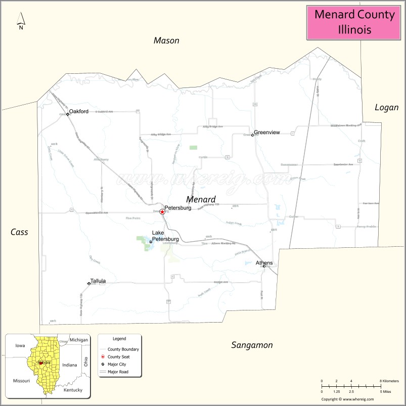
About Menard County Map, Illinois: The map showing the county boundary, county seat, major cities, highways, water bodies and neighbouring counties.
Most Viewed Illinois Links
Menard County, Illinois
Menard County is a county located in the U.S. state of Illinois. It's county seat is Petersburg. As per 2020 census, the population of Menard County is 12164 people and population density is square miles. According to the United States Census Bureau, the county has a total area of 314 sq mi (813 km2). Menard County was established on 1839.
Facts about Menard County, Illinois
| Country | United States |
| State | Illinois |
| Region | Central Illinois |
| County Seat | Petersburg |
| Named After | Pierre Menard |
| Established | 1839 |
| Organized | 1839 |
| Coordinates | 40.03° N, 89.80° W |
| Total Area | ~315 sq mi |
| Land Area | ~314 sq mi |
| Water Area | ~1 sq mi |
| Population (2020) | ~12,038 |
| Population Rank | Small county in Illinois |
| Largest City | Petersburg |
| Main Industries | Agriculture, Healthcare, Education, Retail |
| Major Highways | Illinois Route 97, Illinois Route 123 |
| Time Zone | Central Time (UTC−06:00) |
| Known For | Abraham Lincoln heritage, rural landscape, Sangamon River |
| Website | https://www.menardcountyil.gov |
Ctities in Menard county
| City Name | Type | Population (2020) | Pop. Density | Area |
|---|---|---|---|---|
| Athens | City | 1,977 | 1,175.4/sq mi (453.8/km2) | 1.682 sq mi (4.36 km2) |
| Greenview | Village | 745 | 867.3/sq mi (334.9/km2) | 0.859 sq mi (2.22 km2) |
| Oakford | Village | 234 | 939.8/sq mi (362.8/km2) | 0.249 sq mi (0.64 km2) |
| Petersburg | City | 2,258 | 1,445.6/sq mi (558.1/km2) | 1.562 sq mi (4.05 km2) |
| Tallula | Village | 434 | 817.3/sq mi (315.6/km2) | 0.531 sq mi (1.38 km2) |
Roads and Highways in Menard County, Illinois
Menard County is connected by key highways that provide access to central Illinois and nearby Springfield.
- Illinois Route 29 – runs north-south through the county, connecting Petersburg to Springfield and Mason County
- Illinois Route 97 – runs north-south, linking Petersburg to Springfield and Havana
- Illinois Route 123 – runs east-west, connecting Petersburg to Ashland and Riverton
- Illinois Route 29/97 overlap – serves central areas of the county and connects major communities
Neighboring Counties of Menard County
- Mason County (north)
- Logan County (northeast)
- Sangamon County (south)
- Cass County (west)
Top Attractions in Menard County, Illinois
Menard County offers historic sites, scenic landscapes, and small-town charm near the Illinois River.
- Lincoln’s New Salem State Historic Site – A reconstructed village where Abraham Lincoln lived and worked.
- Menard County Courthouse – A historic landmark located in Petersburg.
- Illinois River Valley Views – Provide scenic overlooks and outdoor recreation opportunities.
- Petersburg Downtown Square – Features shops, dining, and historic buildings.
- Hand of Fate Brewing Company – A local brewery with events and tastings.
- Sangamon Valley Trail (nearby) – Offers walking and biking opportunities.
- Menard County Fairgrounds – Hosts local fairs and community events.
Distance from Menard County to Nearby Cities
- Petersburg to Springfield – 25 mi (40 km)
- Petersburg to Lincoln – 35 mi (56 km)
- Petersburg to Peoria – 65 mi (105 km)
- Petersburg to Bloomington – 70 mi (113 km)
- Petersburg to Decatur – 75 mi (121 km)
FAQs about Menard County
Menard County is located in central Illinois, northwest of Springfield along the Illinois River.
The county is known for Lincoln’s New Salem State Historic Site and its historic connection to Abraham Lincoln.
Petersburg is the county seat and the largest city in Menard County.
Yes, visitors can enjoy parks, trails, and scenic river views throughout the county.
Menard County is accessible via Illinois Routes 29, 97, and 123.
- Adams County Map
- Alexander County Map
- Bond County Map
- Boone County Map
- Brown County Map
- Bureau County Map
- Calhoun County Map
- Carroll County Map
- Cass County Map
- Champaign County Map
- Christian County Map
- Clark County Map
- Clay County Map
- Clinton County Map
- Coles County Map
- Cook County Map
- Crawford County Map
- Cumberland County Map
- DeKalb County Map
- DeWitt County Map
- Douglas County Map
- DuPage County Map
- Edgar County Map
- Edwards County Map
- Effingham County Map
- Fayette County Map
- Ford County Map
- Franklin County Map
- Fulton County Map
- Gallatin County Map
- Greene County Map
- Grundy County Map
- Hamilton County Map
- Hancock County Map
- Hardin County Map
- Henderson County Map
- Henry County Map
- Iroquois County Map
- Jackson County Map
- Jasper County Map
- Jefferson County Map
- Jersey County Map
- Jo Daviess County Map
- Johnson County Map
- Kane County Map
- Kankakee County Map
- Kendall County Map
- Knox County Map
- Lake County Map
- LaSalle County Map
- Lawrence County Map
- Lee County Map
- Livingston County Map
- Logan County Map
- McDonough County Map
- McHenry County Map
- McLean County Map
- Macon County Map
- Macoupin County Map
- Madison County Map
- Marion County Map
- Marshall County Map
- Mason County Map
- Massac County Map
- Menard County Map
- Mercer County Map
- Monroe County Map
- Montgomery County Map
- Morgan County Map
- Moultrie County Map
- Ogle County Map
- Peoria County Map
- Perry County Map
- Piatt County Map
- Pike County Map
- Pope County Map
- Pulaski County Map
- Putnam County Map
- Randolph County Map
- Richland County Map
- Rock Island County Map
- St Clair County Map
- Saline County Map
- Sangamon County Map
- Schuyler County Map
- Scott County Map
- Shelby County Map
- Stark County Map
- Stephenson County Map
- Tazewell County Map
- Union County Map
- Vermilion County Map
- Wabash County Map
- Warren County Map
- Washington County Map
- Wayne County Map
- White County Map
- Whiteside County Map
- Will County Map
- Williamson County Map
- Winnebago County Map
- Woodford County Map
- Alabama Counties
- Alaska boroughs
- Arizona Counties
- Arkansas Counties
- California County Map
- Colorado Counties
- Connecticut Counties
- Delaware Counties
- Florida County Map
- Georgia County Map
- Hawaii Counties
- Idaho Counties
- Illinois Counties
- Indiana Counties
- Iowa Counties
- Kansas Counties
- Kentucky Counties
- Louisiana Counties
- Maine Counties
- Maryland Counties
- Massachusetts Counties
- Michigan County Map
- Minnesota Counties
- Mississippi Counties
- Missouri Counties
- Montana Counties
- Nebraska Counties
- Nevada Counties
- New York Counties
- New Hampshire Counties
- New Jersey Counties
- New Mexico Counties
- North Carolina Counties
- North Dakota Counties
- Ohio County Map
- Oklahoma Counties
- Oregon Counties
- Pennsylvania Counties
- Rhode Island Counties
- South Carolina Counties
- South Dakota Counties
- Map of Tennessee
- Texas County Map
- Utah Counties
- Vermont Counties
- Virginia Counties
- Washington Counties
- West Virginia Counties
- Wisconsin Counties
- Wyoming Counties