Map of Morgan County - Morgan County is a county located in the U.S. state of Illinois. Morgan County Map showing cities, highways, important places and water bodies. Get Where is Morgan County located in the map, major cities in Morgan county, population, areas, and places of interest.
Morgan County Map, Illinois
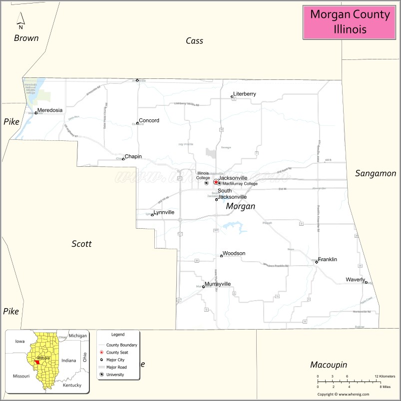
About Morgan County Map, Illinois: The map showing the county boundary, county seat, major cities, highways, water bodies and neighbouring counties.
Most Viewed Illinois Links
Morgan County, Illinois
Morgan County is a county located in the U.S. state of Illinois. It's county seat is Jacksonville. As per 2020 census, the population of Morgan County is 32606 people and population density is square miles. According to the United States Census Bureau, the county has a total area of 568 sq mi (1,471 km2). Morgan County was established on 1823.
Facts about Morgan County, Illinois
| Country | United States |
| State | Illinois |
| Region | West Central Illinois |
| County Seat | Jacksonville |
| Named After | Daniel Morgan |
| Established | 1823 |
| Organized | 1823 |
| Coordinates | 39.72° N, 90.20° W |
| Total Area | ~572 sq mi |
| Land Area | ~569 sq mi |
| Water Area | ~3 sq mi |
| Population (2020) | ~32,915 |
| Population Rank | Mid-sized county in Illinois |
| Largest City | Jacksonville |
| Main Industries | Healthcare, Education, Manufacturing, Agriculture |
| Major Highways | Interstate 72, U.S. Route 67, Illinois Route 104 |
| Time Zone | Central Time (UTC−06:00) |
| Known For | Historic Jacksonville, Illinois College, Morgan County Fair |
| Website | https://www.morgancounty-il.com |
Ctities in Morgan county
| City Name | Type | Population (2020) | Pop. Density | Area |
|---|---|---|---|---|
| Chapin | Village | 475 | 476.0/sq mi (183.8/km2) | 0.998 sq mi (2.58 km2) |
| Concord | Village | 150 | 602.4/sq mi (232.6/km2) | 0.249 sq mi (0.64 km2) |
| Franklin | Village | 610 | 735.8/sq mi (284.1/km2) | 0.829 sq mi (2.15 km2) |
| Jacksonville | City | 17,616 | 1,667.7/sq mi (643.9/km2) | 10.563 sq mi (27.36 km2) |
| Lynnville | Village | 96 | 1,246.8/sq mi (481.4/km2) | 0.077 sq mi (0.2 km2) |
| Meredosia | Village | 826 | 956.0/sq mi (369.1/km2) | 0.864 sq mi (2.24 km2) |
| Murrayville | Village | 567 | 1,143.1/sq mi (441.4/km2) | 0.496 sq mi (1.28 km2) |
| South Jacksonville | Village | 3,302 | 1,452.7/sq mi (560.9/km2) | 2.273 sq mi (5.89 km2) |
| Waverly | City | 1,194 | 1,152.5/sq mi (445.0/km2) | 1.036 sq mi (2.68 km2) |
| Woodson | Village | 498 | 1,264.0/sq mi (488.0/km2) | 0.394 sq mi (1.02 km2) |
Roads and Highways in Morgan County, Illinois
Morgan County is well-connected by major highways that link it to central and western Illinois.
- Interstate 72 – runs east-west through the county, connecting Jacksonville to Springfield and Quincy
- U.S. Route 67 – runs north-south, linking Jacksonville to Beardstown and Macomb
- Illinois Route 104 – runs east-west, connecting Jacksonville to Pittsfield and Taylorville
- Illinois Route 267 – runs north-south, linking Jacksonville to Greenfield and Carrollton
- Illinois Route 78 – runs north-south, connecting Jacksonville to Virginia and Canton
Neighboring Counties of Morgan County
- Cass County (north)
- Sangamon County (east)
- Macoupin County (south)
- Greene County (southwest)
- Scott County (west)
- Brown County (northwest)
Top Attractions in Morgan County, Illinois
Morgan County offers historic sites, parks, and cultural attractions centered around the city of Jacksonville.
- Jacksonville Downtown Historic District – Features shops, dining, and historic architecture.
- Illinois College – A historic campus with cultural and educational significance.
- Woodlawn Farm – A historic site associated with early Illinois history.
- Lake Jacksonville – A popular destination for boating, fishing, and outdoor recreation.
- Morgan County Courthouse – A landmark located in Jacksonville.
- Jacksonville Speedway – Hosts racing events and entertainment.
- Prairie Land Heritage Museum – Showcases local history and artifacts.
Distance from Morgan County to Nearby Cities
- Jacksonville to Springfield – 35 mi (56 km)
- Jacksonville to Quincy – 70 mi (113 km)
- Jacksonville to St. Louis – 90 mi (145 km)
- Jacksonville to Peoria – 100 mi (161 km)
- Jacksonville to Chicago – 230 mi (370 km)
FAQs about Morgan County
Morgan County is located in west-central Illinois, centered around the city of Jacksonville.
The county is known for its historic sites, colleges, and outdoor recreation areas.
Jacksonville is the county seat and the largest city in Morgan County.
Yes, visitors can enjoy lakes, parks, trails, and outdoor recreation throughout the county.
Morgan County is accessible via Interstate 72, U.S. Route 67, and several Illinois state highways.
- Adams County Map
- Alexander County Map
- Bond County Map
- Boone County Map
- Brown County Map
- Bureau County Map
- Calhoun County Map
- Carroll County Map
- Cass County Map
- Champaign County Map
- Christian County Map
- Clark County Map
- Clay County Map
- Clinton County Map
- Coles County Map
- Cook County Map
- Crawford County Map
- Cumberland County Map
- DeKalb County Map
- DeWitt County Map
- Douglas County Map
- DuPage County Map
- Edgar County Map
- Edwards County Map
- Effingham County Map
- Fayette County Map
- Ford County Map
- Franklin County Map
- Fulton County Map
- Gallatin County Map
- Greene County Map
- Grundy County Map
- Hamilton County Map
- Hancock County Map
- Hardin County Map
- Henderson County Map
- Henry County Map
- Iroquois County Map
- Jackson County Map
- Jasper County Map
- Jefferson County Map
- Jersey County Map
- Jo Daviess County Map
- Johnson County Map
- Kane County Map
- Kankakee County Map
- Kendall County Map
- Knox County Map
- Lake County Map
- LaSalle County Map
- Lawrence County Map
- Lee County Map
- Livingston County Map
- Logan County Map
- McDonough County Map
- McHenry County Map
- McLean County Map
- Macon County Map
- Macoupin County Map
- Madison County Map
- Marion County Map
- Marshall County Map
- Mason County Map
- Massac County Map
- Menard County Map
- Mercer County Map
- Monroe County Map
- Montgomery County Map
- Morgan County Map
- Moultrie County Map
- Ogle County Map
- Peoria County Map
- Perry County Map
- Piatt County Map
- Pike County Map
- Pope County Map
- Pulaski County Map
- Putnam County Map
- Randolph County Map
- Richland County Map
- Rock Island County Map
- St Clair County Map
- Saline County Map
- Sangamon County Map
- Schuyler County Map
- Scott County Map
- Shelby County Map
- Stark County Map
- Stephenson County Map
- Tazewell County Map
- Union County Map
- Vermilion County Map
- Wabash County Map
- Warren County Map
- Washington County Map
- Wayne County Map
- White County Map
- Whiteside County Map
- Will County Map
- Williamson County Map
- Winnebago County Map
- Woodford County Map
- Alabama Counties
- Alaska boroughs
- Arizona Counties
- Arkansas Counties
- California County Map
- Colorado Counties
- Connecticut Counties
- Delaware Counties
- Florida County Map
- Georgia County Map
- Hawaii Counties
- Idaho Counties
- Illinois Counties
- Indiana Counties
- Iowa Counties
- Kansas Counties
- Kentucky Counties
- Louisiana Counties
- Maine Counties
- Maryland Counties
- Massachusetts Counties
- Michigan County Map
- Minnesota Counties
- Mississippi Counties
- Missouri Counties
- Montana Counties
- Nebraska Counties
- Nevada Counties
- New York Counties
- New Hampshire Counties
- New Jersey Counties
- New Mexico Counties
- North Carolina Counties
- North Dakota Counties
- Ohio County Map
- Oklahoma Counties
- Oregon Counties
- Pennsylvania Counties
- Rhode Island Counties
- South Carolina Counties
- South Dakota Counties
- Map of Tennessee
- Texas County Map
- Utah Counties
- Vermont Counties
- Virginia Counties
- Washington Counties
- West Virginia Counties
- Wisconsin Counties
- Wyoming Counties