Map of DuPage County - DuPage County is a county located in the U.S. state of Illinois. DuPage County Map showing cities, highways, important places and water bodies. Get Where is DuPage County located in the map, major cities in DuPage county, population, areas, and places of interest.
DuPage County Map, Illinois
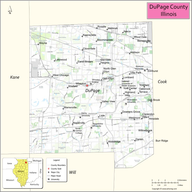
About DuPage County Map, Illinois: The map showing the county boundary, county seat, major cities, highways, water bodies and neighbouring counties.
Most Viewed Illinois Links
DuPage County, Illinois
DuPage County is a county located in the U.S. state of Illinois. It's county seat is Wheaton. As per 2020 census, the population of DuPage County is 924885 people and population density is square miles. According to the United States Census Bureau, the county has a total area of 327 sq mi (847 km2). DuPage County was established on 1839.
Facts about DuPage County, Illinois
| Country | United States |
| State | Illinois |
| Region | Northeastern Illinois |
| County Seat | Wheaton |
| Named After | DuPage River |
| Established | 1839 |
| Organized | 1839 |
| Coordinates | 41.84° N, 88.09° W |
| Total Area | ~336 sq mi |
| Land Area | ~327 sq mi |
| Water Area | ~9 sq mi |
| Population (2020) | ~932,877 |
| Population Rank | Second most populous county in Illinois |
| Largest Cities | Aurora, Naperville |
| Main Industries | Technology, Healthcare, Finance, Corporate Services |
| Major Highways | Interstate 88, Interstate 355 |
| Time Zone | Central Time (UTC−06:00) |
| Known For | Chicago suburbs, high quality of life, corporate headquarters |
| Website | https://www.dupagecounty.gov |
Ctities in DuPage county
| City Name | Type | Population (2020) | Pop. Density | Area |
|---|---|---|---|---|
| Lemont | Village | 17,629 | 2,118.6/sq mi (818.0/km2) | 8.321 sq mi (21.55 km2) |
| Bartlett | Village | 41,105 | 2,613.8/sq mi (1,009.2/km2) | 15.726 sq mi (40.73 km2) |
| Addison | Village | 35,702 | 3,632.3/sq mi (1,402.4/km2) | 9.829 sq mi (25.46 km2) |
| Bensenville | Village | 18,813 | 3,402.0/sq mi (1,313.5/km2) | 5.53 sq mi (14.32 km2) |
| Bloomingdale | Village | 22,382 | 3,308.0/sq mi (1,277.2/km2) | 6.766 sq mi (17.52 km2) |
| Carol Stream | Village | 39,854 | 4,370.4/sq mi (1,687.4/km2) | 9.119 sq mi (23.62 km2) |
| Clarendon Hills | Village | 8,702 | 4,807.7/sq mi (1,856.3/km2) | 1.81 sq mi (4.69 km2) |
| Darien | City | 22,011 | 3,566.8/sq mi (1,377.2/km2) | 6.171 sq mi (15.98 km2) |
| Downers Grove | Village | 50,247 | 3,431.5/sq mi (1,324.9/km2) | 14.643 sq mi (37.93 km2) |
| Elmhurst | City | 45,786 | 4,480.9/sq mi (1,730.1/km2) | 10.218 sq mi (26.46 km2) |
| Glendale Heights | Village | 33,176 | 6,160.8/sq mi (2,378.7/km2) | 5.385 sq mi (13.95 km2) |
| Glen Ellyn | Village | 28,846 | 4,211.1/sq mi (1,625.9/km2) | 6.85 sq mi (17.74 km2) |
| Hanover Park | Village | 37,470 | 5,834.6/sq mi (2,252.8/km2) | 6.422 sq mi (16.63 km2) |
| Itasca | Village | 9,543 | 1,900.2/sq mi (733.7/km2) | 5.022 sq mi (13.01 km2) |
| Lisle | Village | 24,223 | 3,510.1/sq mi (1,355.2/km2) | 6.901 sq mi (17.87 km2) |
| Lombard | Village | 44,476 | 4,351.9/sq mi (1,680.3/km2) | 10.22 sq mi (26.47 km2) |
| Oak Brook | Village | 8,163 | 1,025.6/sq mi (396.0/km2) | 7.959 sq mi (20.61 km2) |
| Oakbrook Terrace | City | 2,751 | 2,106.4/sq mi (813.3/km2) | 1.306 sq mi (3.38 km2) |
| Villa Park | Village | 22,263 | 4,713.7/sq mi (1,820.0/km2) | 4.723 sq mi (12.23 km2) |
| Warrenville | City | 13,553 | 2,482.2/sq mi (958.4/km2) | 5.46 sq mi (14.14 km2) |
| West Chicago | City | 25,614 | 1,665.8/sq mi (643.2/km2) | 15.376 sq mi (39.82 km2) |
| Westmont | Village | 24,429 | 4,881.9/sq mi (1,884.9/km2) | 5.004 sq mi (12.96 km2) |
| Wheaton | City | 53,970 | 4,768.1/sq mi (1,841.0/km2) | 11.319 sq mi (29.32 km2) |
| Willowbrook | Village | 9,236 | 3,591.0/sq mi (1,386.5/km2) | 2.572 sq mi (6.66 km2) |
| Winfield | Village | 9,835 | 3,182.8/sq mi (1,228.9/km2) | 3.09 sq mi (8 km2) |
| Wood Dale | City | 14,012 | 2,929.5/sq mi (1,131.1/km2) | 4.783 sq mi (12.39 km2) |
| Woodridge | Village | 34,158 | 3,541.5/sq mi (1,367.4/km2) | 9.645 sq mi (24.98 km2) |
| Burr Ridge | Village | 11,192 | 1,566.8/sq mi (605.0/km2) | 7.143 sq mi (18.5 km2) |
| Hinsdale | Village | 17,395 | 3,762.7/sq mi (1,452.8/km2) | 4.623 sq mi (11.97 km2) |
| Roselle | Village | 22,897 | 4,135.3/sq mi (1,596.6/km2) | 5.537 sq mi (14.34 km2) |
| Wayne | Village | 2,286 | 399.0/sq mi (154.0/km2) | 5.73 sq mi (14.84 km2) |
| Naperville | City | 149,540 | 3,826.8/sq mi (1,477.5/km2) | 39.077 sq mi (101.21 km2) |
| St. Charles | City | 33,081 | 2,297.1/sq mi (886.9/km2) | 14.401 sq mi (37.3 km2) |
| Aurora | City | 180,542 | 4,010.0/sq mi (1,548.3/km2) | 45.023 sq mi (116.61 km2) |
| Bolingbrook | Village | 73,922 | 2,975.3/sq mi (1,148.8/km2) | 24.845 sq mi (64.35 km2) |
Roads and Highways in DuPage County, Illinois
DuPage County is a major suburban transportation hub with an extensive highway network connecting it to Chicago and surrounding regions.
- Interstate 88 – runs east-west through the county, connecting Naperville to Chicago and the Quad Cities
- Interstate 355 – runs north-south, linking the county to I-80 and I-290
- Interstate 290 – connects the eastern part of the county to downtown Chicago
- U.S. Route 34 – runs east-west, linking Lisle and Naperville to Aurora and Chicago suburbs
- Illinois Route 59 – runs north-south through the county, connecting Naperville to Bartlett and surrounding areas
Neighboring Counties of DuPage County
- Cook County (east)
- Lake County (north)
- Kane County (west)
- Will County (south)
Top Attractions in DuPage County, Illinois
DuPage County offers a mix of nature preserves, cultural sites, and family-friendly attractions across its suburban communities.
- Morton Arboretum – A large outdoor museum with gardens, trails, and seasonal exhibits.
- Cantigny Park – Features gardens, museums, and walking paths in a scenic setting.
- Brookfield Zoo (nearby) – A major zoo attraction located just outside the county.
- Naperville Riverwalk – A popular destination with scenic paths, fountains, and dining areas.
- DuPage Children's Museum – Offers interactive exhibits for families and kids.
- Blackwell Forest Preserve – Provides trails, fishing areas, and picnic spots.
- Graue Mill and Museum – A historic mill with exhibits on local history and the Underground Railroad.
- Oakbrook Center – A large outdoor shopping center with retail, dining, and entertainment.
Distance from DuPage County to Nearby Cities
- Naperville to Chicago – 30 mi (48 km)
- Naperville to Aurora – 10 mi (16 km)
- Naperville to Joliet – 25 mi (40 km)
- Naperville to Rockford – 75 mi (121 km)
- Naperville to Milwaukee – 100 mi (161 km)
FAQs about DuPage County
DuPage County is located in northeastern Illinois, just west of Chicago.
The county is known for its suburban communities, parks, cultural attractions, and proximity to Chicago.
Wheaton is the county seat of DuPage County.
Yes, visitors can enjoy forest preserves, parks, trails, and outdoor recreational areas throughout the county.
DuPage County is accessible via several interstates including I-88, I-355, and I-290, along with major state routes.
- Adams County Map
- Alexander County Map
- Bond County Map
- Boone County Map
- Brown County Map
- Bureau County Map
- Calhoun County Map
- Carroll County Map
- Cass County Map
- Champaign County Map
- Christian County Map
- Clark County Map
- Clay County Map
- Clinton County Map
- Coles County Map
- Cook County Map
- Crawford County Map
- Cumberland County Map
- DeKalb County Map
- DeWitt County Map
- Douglas County Map
- DuPage County Map
- Edgar County Map
- Edwards County Map
- Effingham County Map
- Fayette County Map
- Ford County Map
- Franklin County Map
- Fulton County Map
- Gallatin County Map
- Greene County Map
- Grundy County Map
- Hamilton County Map
- Hancock County Map
- Hardin County Map
- Henderson County Map
- Henry County Map
- Iroquois County Map
- Jackson County Map
- Jasper County Map
- Jefferson County Map
- Jersey County Map
- Jo Daviess County Map
- Johnson County Map
- Kane County Map
- Kankakee County Map
- Kendall County Map
- Knox County Map
- Lake County Map
- LaSalle County Map
- Lawrence County Map
- Lee County Map
- Livingston County Map
- Logan County Map
- McDonough County Map
- McHenry County Map
- McLean County Map
- Macon County Map
- Macoupin County Map
- Madison County Map
- Marion County Map
- Marshall County Map
- Mason County Map
- Massac County Map
- Menard County Map
- Mercer County Map
- Monroe County Map
- Montgomery County Map
- Morgan County Map
- Moultrie County Map
- Ogle County Map
- Peoria County Map
- Perry County Map
- Piatt County Map
- Pike County Map
- Pope County Map
- Pulaski County Map
- Putnam County Map
- Randolph County Map
- Richland County Map
- Rock Island County Map
- St Clair County Map
- Saline County Map
- Sangamon County Map
- Schuyler County Map
- Scott County Map
- Shelby County Map
- Stark County Map
- Stephenson County Map
- Tazewell County Map
- Union County Map
- Vermilion County Map
- Wabash County Map
- Warren County Map
- Washington County Map
- Wayne County Map
- White County Map
- Whiteside County Map
- Will County Map
- Williamson County Map
- Winnebago County Map
- Woodford County Map
- Alabama Counties
- Alaska boroughs
- Arizona Counties
- Arkansas Counties
- California County Map
- Colorado Counties
- Connecticut Counties
- Delaware Counties
- Florida County Map
- Georgia County Map
- Hawaii Counties
- Idaho Counties
- Illinois Counties
- Indiana Counties
- Iowa Counties
- Kansas Counties
- Kentucky Counties
- Louisiana Counties
- Maine Counties
- Maryland Counties
- Massachusetts Counties
- Michigan County Map
- Minnesota Counties
- Mississippi Counties
- Missouri Counties
- Montana Counties
- Nebraska Counties
- Nevada Counties
- New York Counties
- New Hampshire Counties
- New Jersey Counties
- New Mexico Counties
- North Carolina Counties
- North Dakota Counties
- Ohio County Map
- Oklahoma Counties
- Oregon Counties
- Pennsylvania Counties
- Rhode Island Counties
- South Carolina Counties
- South Dakota Counties
- Map of Tennessee
- Texas County Map
- Utah Counties
- Vermont Counties
- Virginia Counties
- Washington Counties
- West Virginia Counties
- Wisconsin Counties
- Wyoming Counties