Map of Ogle County - Ogle County is a county located in the U.S. state of Illinois. Ogle County Map showing cities, highways, important places and water bodies. Get Where is Ogle County located in the map, major cities in Ogle county, population, areas, and places of interest.
Ogle County Map, Illinois
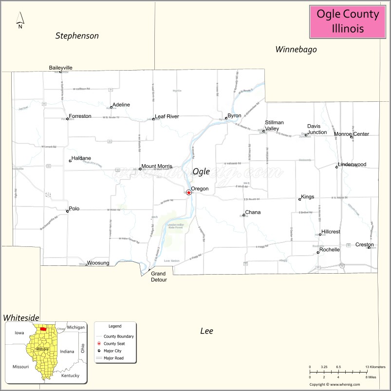
About Ogle County Map, Illinois: The map showing the county boundary, county seat, major cities, highways, water bodies and neighbouring counties.
Most Viewed Illinois Links
Ogle County, Illinois
Ogle County is a county located in the U.S. state of Illinois. It's county seat is Oregon. As per 2020 census, the population of Ogle County is 51449 people and population density is square miles. According to the United States Census Bureau, the county has a total area of 758 sq mi (1,963 km2). Ogle County was established on 1836.
Facts about Ogle County, Illinois
| Country | United States |
| State | Illinois |
| Region | Northern Illinois |
| County Seat | Oregon |
| Named After | Joseph Ogle |
| Established | 1836 |
| Organized | 1836 |
| Coordinates | 42.04° N, 89.32° W |
| Total Area | ~763 sq mi |
| Land Area | ~759 sq mi |
| Water Area | ~4 sq mi |
| Population (2020) | ~51,788 |
| Population Rank | Mid-sized county in Illinois |
| Largest City | Rochelle |
| Main Industries | Agriculture, Manufacturing, Transportation |
| Major Highways | Interstate 39, Interstate 88, U.S. Route 52 |
| Time Zone | Central Time (UTC−06:00) |
| Known For | Rock River, White Pines Forest State Park, rural landscape |
| Website | https://www.oglecountyil.gov |
Ctities in Ogle county
| City Name | Type | Population (2020) | Pop. Density | Area |
|---|---|---|---|---|
| Adeline | Village | 78 | 293.2/sq mi (113.2/km2) | 0.266 sq mi (0.69 km2) |
| Byron | City | 3,784 | 813.8/sq mi (314.2/km2) | 4.65 sq mi (12.04 km2) |
| Creston | Village | 627 | 547.1/sq mi (211.2/km2) | 1.146 sq mi (2.97 km2) |
| Davis Junction | Village | 2,512 | 598.1/sq mi (230.9/km2) | 4.2 sq mi (10.88 km2) |
| Forreston | Village | 1,435 | 1,521.7/sq mi (587.5/km2) | 0.943 sq mi (2.44 km2) |
| Hillcrest | Village | 1,224 | 344.9/sq mi (133.2/km2) | 3.549 sq mi (9.19 km2) |
| Leaf River | Village | 432 | 497.1/sq mi (191.9/km2) | 0.869 sq mi (2.25 km2) |
| Monroe Center | Village | 411 | 339.1/sq mi (130.9/km2) | 1.212 sq mi (3.14 km2) |
| Mount Morris | Village | 2,861 | 1,834.0/sq mi (708.1/km2) | 1.56 sq mi (4.04 km2) |
| Oregon | City | 3,604 | 1,870.3/sq mi (722.1/km2) | 1.927 sq mi (4.99 km2) |
| Polo | City | 2,291 | 1,717.4/sq mi (663.1/km2) | 1.334 sq mi (3.46 km2) |
| Rochelle | City | 9,446 | 710.4/sq mi (274.3/km2) | 13.296 sq mi (34.44 km2) |
| Stillman Valley | Village | 1,075 | 1,886.0/sq mi (728.2/km2) | 0.57 sq mi (1.48 km2) |
Roads and Highways in Ogle County, Illinois
Ogle County is well-connected by major highways that provide access to northern Illinois and nearby cities.
- Interstate 39 – runs north-south through the county, connecting Rochelle to Rockford and Bloomington
- Illinois Route 64 – runs east-west, linking Oregon to Sycamore and Mount Morris
- Illinois Route 2 – runs north-south along the Rock River, connecting Oregon to Dixon and Rockford
- Illinois Route 38 – runs east-west, connecting Rochelle to DeKalb and Ashton
- Illinois Route 72 – runs east-west, linking Byron to Leaf River and Stillman Valley
Neighboring Counties of Ogle County
- Winnebago County (north)
- Boone County (northeast)
- DeKalb County (east)
- Lee County (south)
- Carroll County (west)
- Stephenson County (northwest)
Top Attractions in Ogle County, Illinois
Ogle County offers scenic landscapes, parks, and historic sites centered around the Rock River Valley.
- Lowden State Park – Known for the Black Hawk Statue and scenic river views.
- White Pines Forest State Park – Offers hiking, cabins, and beautiful wooded areas.
- Castle Rock State Park – Features trails, rock formations, and panoramic views.
- Byron Forest Preserve District – Provides trails, nature centers, and outdoor programs.
- Oregon Downtown Area – Features shops, dining, and historic architecture.
- Rochelle Railroad Park – A popular train-watching destination.
- Stronghold Castle – A unique historic structure with tours and events.
Distance from Ogle County to Nearby Cities
- Oregon to Rockford – 30 mi (48 km)
- Rochelle to DeKalb – 25 mi (40 km)
- Oregon to Chicago – 100 mi (161 km)
- Rochelle to Aurora – 55 mi (89 km)
- Oregon to Freeport – 40 mi (64 km)
FAQs about Ogle County
Ogle County is located in northern Illinois, centered around the Rock River Valley.
The county is known for its state parks, scenic river views, and outdoor recreation.
Oregon is the county seat and a historic city in Ogle County.
Yes, visitors can enjoy parks, trails, rivers, and outdoor recreation throughout the county.
Ogle County is accessible via Interstate 39 and several Illinois state highways.
- Adams County Map
- Alexander County Map
- Bond County Map
- Boone County Map
- Brown County Map
- Bureau County Map
- Calhoun County Map
- Carroll County Map
- Cass County Map
- Champaign County Map
- Christian County Map
- Clark County Map
- Clay County Map
- Clinton County Map
- Coles County Map
- Cook County Map
- Crawford County Map
- Cumberland County Map
- DeKalb County Map
- DeWitt County Map
- Douglas County Map
- DuPage County Map
- Edgar County Map
- Edwards County Map
- Effingham County Map
- Fayette County Map
- Ford County Map
- Franklin County Map
- Fulton County Map
- Gallatin County Map
- Greene County Map
- Grundy County Map
- Hamilton County Map
- Hancock County Map
- Hardin County Map
- Henderson County Map
- Henry County Map
- Iroquois County Map
- Jackson County Map
- Jasper County Map
- Jefferson County Map
- Jersey County Map
- Jo Daviess County Map
- Johnson County Map
- Kane County Map
- Kankakee County Map
- Kendall County Map
- Knox County Map
- Lake County Map
- LaSalle County Map
- Lawrence County Map
- Lee County Map
- Livingston County Map
- Logan County Map
- McDonough County Map
- McHenry County Map
- McLean County Map
- Macon County Map
- Macoupin County Map
- Madison County Map
- Marion County Map
- Marshall County Map
- Mason County Map
- Massac County Map
- Menard County Map
- Mercer County Map
- Monroe County Map
- Montgomery County Map
- Morgan County Map
- Moultrie County Map
- Ogle County Map
- Peoria County Map
- Perry County Map
- Piatt County Map
- Pike County Map
- Pope County Map
- Pulaski County Map
- Putnam County Map
- Randolph County Map
- Richland County Map
- Rock Island County Map
- St Clair County Map
- Saline County Map
- Sangamon County Map
- Schuyler County Map
- Scott County Map
- Shelby County Map
- Stark County Map
- Stephenson County Map
- Tazewell County Map
- Union County Map
- Vermilion County Map
- Wabash County Map
- Warren County Map
- Washington County Map
- Wayne County Map
- White County Map
- Whiteside County Map
- Will County Map
- Williamson County Map
- Winnebago County Map
- Woodford County Map
- Alabama Counties
- Alaska boroughs
- Arizona Counties
- Arkansas Counties
- California County Map
- Colorado Counties
- Connecticut Counties
- Delaware Counties
- Florida County Map
- Georgia County Map
- Hawaii Counties
- Idaho Counties
- Illinois Counties
- Indiana Counties
- Iowa Counties
- Kansas Counties
- Kentucky Counties
- Louisiana Counties
- Maine Counties
- Maryland Counties
- Massachusetts Counties
- Michigan County Map
- Minnesota Counties
- Mississippi Counties
- Missouri Counties
- Montana Counties
- Nebraska Counties
- Nevada Counties
- New York Counties
- New Hampshire Counties
- New Jersey Counties
- New Mexico Counties
- North Carolina Counties
- North Dakota Counties
- Ohio County Map
- Oklahoma Counties
- Oregon Counties
- Pennsylvania Counties
- Rhode Island Counties
- South Carolina Counties
- South Dakota Counties
- Map of Tennessee
- Texas County Map
- Utah Counties
- Vermont Counties
- Virginia Counties
- Washington Counties
- West Virginia Counties
- Wisconsin Counties
- Wyoming Counties