Map of Cumberland County - Cumberland County is a county located in the U.S. state of Illinois. Cumberland County Map showing cities, highways, important places and water bodies. Get Where is Cumberland County located in the map, major cities in Cumberland county, population, areas, and places of interest.
Cumberland County Map, Illinois
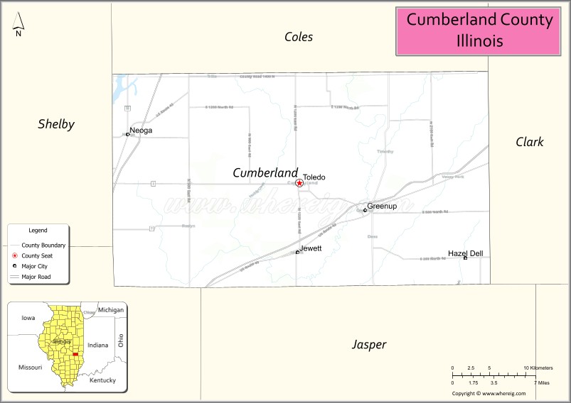
About Cumberland County Map, Illinois: The map showing the county boundary, county seat, major cities, highways, water bodies and neighbouring counties.
Most Viewed Illinois Links
Cumberland County, Illinois
Cumberland County is a county located in the U.S. state of Illinois. It's county seat is Toledo. As per 2020 census, the population of Cumberland County is 10345 people and population density is square miles. According to the United States Census Bureau, the county has a total area of 345 sq mi (894 km2). Cumberland County was established on 1843.
Facts about Cumberland County, Illinois
| Country | United States |
| State | Illinois |
| Region | East Central Illinois |
| County Seat | Toledo |
| Named After | Cumberland Road |
| Established | 1843 |
| Organized | 1843 |
| Coordinates | 39.27° N, 88.24° W |
| Total Area | ~347 sq mi |
| Land Area | ~346 sq mi |
| Water Area | ~1 sq mi |
| Population (2020) | ~10,824 |
| Population Rank | Small-sized county in Illinois |
| Largest City | Toledo |
| Main Industries | Agriculture, Manufacturing, Healthcare |
| Major Highways | Interstate 57, Illinois Route 121 |
| Time Zone | Central Time (UTC−06:00) |
| Known For | Rural farmland, small communities, agricultural production |
| Website | https://www.cumberlandcountyil.gov |
Ctities in Cumberland county
| City Name | Type | Population (2020) | Pop. Density | Area |
|---|---|---|---|---|
| Casey | City | 2,404 | 1,062.3/sq mi (410.2/km2) | 2.263 sq mi (5.86 km2) |
| Greenup | Village | 1,365 | 780.0/sq mi (301.2/km2) | 1.75 sq mi (4.53 km2) |
| Jewett | Village | 196 | 195.0/sq mi (75.3/km2) | 1.005 sq mi (2.6 km2) |
| Neoga | City | 1,398 | 1,005.8/sq mi (388.3/km2) | 1.39 sq mi (3.6 km2) |
| Toledo | Village | 1,161 | 1,307.4/sq mi (504.8/km2) | 0.888 sq mi (2.3 km2) |
Roads and Highways in Cumberland County, Illinois
Cumberland County is served by key highways that provide access to east-central Illinois and nearby regional cities.
- Interstate 70 – runs east-west through the county, connecting Greenup to Effingham and Terre Haute
- U.S. Route 40 – parallels I-70, linking Greenup to Casey and surrounding communities
- Illinois Route 121 – runs north-south, connecting Greenup to Mattoon and Vandalia
- Illinois Route 130 – passes near the county, linking the area to Effingham and Charleston
Neighboring Counties of Cumberland County
- Coles County (north)
- Clark County (east)
- Jasper County (south)
- Effingham County (southwest)
- Shelby County (west)
Top Attractions in Cumberland County, Illinois
Cumberland County offers a peaceful rural setting with local parks, community events, and nearby outdoor recreation areas.
- Greenup Historic District – A small-town area with historic buildings and local charm.
- Greenup City Park – A community park with playgrounds and open green space.
- Cumberland County Fairgrounds – Hosts the annual county fair and local events.
- Embarras River Area – Offers scenic views and opportunities for fishing and nature walks.
- Lincoln Log Cabin State Historic Site (nearby) – A historic site preserving early pioneer life.
- Ballard Nature Center (nearby) – Provides trails, wildlife viewing, and educational programs.
- Casey Area Attractions – Known for nearby giant roadside attractions and parks.
Distance from Cumberland County to Nearby Cities
- Greenup to Effingham – 25 mi (40 km)
- Greenup to Charleston – 35 mi (56 km)
- Greenup to Terre Haute – 45 mi (72 km)
- Greenup to Champaign – 90 mi (145 km)
- Greenup to Springfield – 120 mi (193 km)
FAQs about Cumberland County
Cumberland County is located in east-central Illinois, near the Indiana border.
The county is known for its rural landscapes, community events, and small-town atmosphere.
Greenup is the county seat and main community in Cumberland County.
Yes, visitors can enjoy parks, river areas, and nearby nature centers for outdoor recreation.
Cumberland County is accessible via Interstate 70, U.S. Route 40, and Illinois Route 121.
- Adams County Map
- Alexander County Map
- Bond County Map
- Boone County Map
- Brown County Map
- Bureau County Map
- Calhoun County Map
- Carroll County Map
- Cass County Map
- Champaign County Map
- Christian County Map
- Clark County Map
- Clay County Map
- Clinton County Map
- Coles County Map
- Cook County Map
- Crawford County Map
- Cumberland County Map
- DeKalb County Map
- DeWitt County Map
- Douglas County Map
- DuPage County Map
- Edgar County Map
- Edwards County Map
- Effingham County Map
- Fayette County Map
- Ford County Map
- Franklin County Map
- Fulton County Map
- Gallatin County Map
- Greene County Map
- Grundy County Map
- Hamilton County Map
- Hancock County Map
- Hardin County Map
- Henderson County Map
- Henry County Map
- Iroquois County Map
- Jackson County Map
- Jasper County Map
- Jefferson County Map
- Jersey County Map
- Jo Daviess County Map
- Johnson County Map
- Kane County Map
- Kankakee County Map
- Kendall County Map
- Knox County Map
- Lake County Map
- LaSalle County Map
- Lawrence County Map
- Lee County Map
- Livingston County Map
- Logan County Map
- McDonough County Map
- McHenry County Map
- McLean County Map
- Macon County Map
- Macoupin County Map
- Madison County Map
- Marion County Map
- Marshall County Map
- Mason County Map
- Massac County Map
- Menard County Map
- Mercer County Map
- Monroe County Map
- Montgomery County Map
- Morgan County Map
- Moultrie County Map
- Ogle County Map
- Peoria County Map
- Perry County Map
- Piatt County Map
- Pike County Map
- Pope County Map
- Pulaski County Map
- Putnam County Map
- Randolph County Map
- Richland County Map
- Rock Island County Map
- St Clair County Map
- Saline County Map
- Sangamon County Map
- Schuyler County Map
- Scott County Map
- Shelby County Map
- Stark County Map
- Stephenson County Map
- Tazewell County Map
- Union County Map
- Vermilion County Map
- Wabash County Map
- Warren County Map
- Washington County Map
- Wayne County Map
- White County Map
- Whiteside County Map
- Will County Map
- Williamson County Map
- Winnebago County Map
- Woodford County Map
- Alabama Counties
- Alaska boroughs
- Arizona Counties
- Arkansas Counties
- California County Map
- Colorado Counties
- Connecticut Counties
- Delaware Counties
- Florida County Map
- Georgia County Map
- Hawaii Counties
- Idaho Counties
- Illinois Counties
- Indiana Counties
- Iowa Counties
- Kansas Counties
- Kentucky Counties
- Louisiana Counties
- Maine Counties
- Maryland Counties
- Massachusetts Counties
- Michigan County Map
- Minnesota Counties
- Mississippi Counties
- Missouri Counties
- Montana Counties
- Nebraska Counties
- Nevada Counties
- New York Counties
- New Hampshire Counties
- New Jersey Counties
- New Mexico Counties
- North Carolina Counties
- North Dakota Counties
- Ohio County Map
- Oklahoma Counties
- Oregon Counties
- Pennsylvania Counties
- Rhode Island Counties
- South Carolina Counties
- South Dakota Counties
- Map of Tennessee
- Texas County Map
- Utah Counties
- Vermont Counties
- Virginia Counties
- Washington Counties
- West Virginia Counties
- Wisconsin Counties
- Wyoming Counties