Map of Winnebago County - Winnebago County is a county located in the U.S. state of Illinois. Winnebago County Map showing cities, highways, important places and water bodies. Get Where is Winnebago County located in the map, major cities in Winnebago county, population, areas, and places of interest.
Winnebago County Map, Illinois
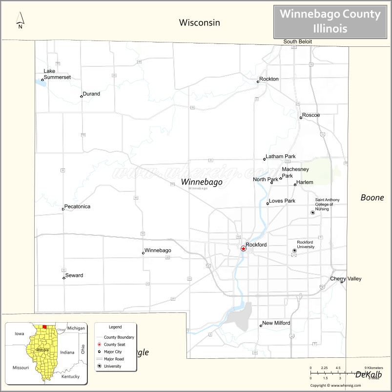
About Winnebago County Map, Illinois: The map showing the county boundary, county seat, major cities, highways, water bodies and neighbouring counties.
Most Viewed Illinois Links
Winnebago County, Illinois
Winnebago County is a county located in the U.S. state of Illinois. It's county seat is Rockford. As per 2020 census, the population of Winnebago County is 283119 people and population density is square miles. According to the United States Census Bureau, the county has a total area of 513 sq mi (1,329 km2). Winnebago County was established on 1836.
Facts about Winnebago County, Illinois
| Country | United States |
| State | Illinois |
| Region | Northern Illinois |
| County Seat | Rockford |
| Named After | Winnebago (Ho-Chunk) people |
| Established | 1836 |
| Organized | 1836 |
| Coordinates | 42.34° N, 89.16° W |
| Total Area | ~519 sq mi |
| Land Area | ~513 sq mi |
| Water Area | ~6 sq mi |
| Population (2020) | ~285,350 |
| Population Rank | Second-most populous county in Illinois |
| Largest City | Rockford |
| Main Industries | Manufacturing, Healthcare, Aerospace, Logistics |
| Major Highways | Interstate 90, Interstate 39, U.S. Route 20 |
| Time Zone | Central Time (UTC−06:00) |
| Known For | Rockford metro area, manufacturing heritage, Rock River corridor |
| Website | https://www.wincoil.gov |
Ctities in Winnebago county
| City Name | Type | Population (2020) | Pop. Density | Area |
|---|---|---|---|---|
| Cherry Valley | Village | 2,905 | 345.6/sq mi (133.4/km2) | 8.405 sq mi (21.77 km2) |
| Durand | Village | 1,390 | 1,512.5/sq mi (584.0/km2) | 0.919 sq mi (2.38 km2) |
| Machesney Park | Village | 22,950 | 1,809.2/sq mi (698.5/km2) | 12.685 sq mi (32.85 km2) |
| New Milford | Village | 794 | 312.2/sq mi (120.6/km2) | 2.543 sq mi (6.59 km2) |
| Pecatonica | Village | 2,090 | 1,629.0/sq mi (629.0/km2) | 1.283 sq mi (3.32 km2) |
| Rockford | City | 148,655 | 2,303.2/sq mi (889.3/km2) | 64.544 sq mi (167.17 km2) |
| Rockton | Village | 7,863 | 1,145.9/sq mi (442.4/km2) | 6.862 sq mi (17.77 km2) |
| Roscoe | Village | 10,983 | 1,069.9/sq mi (413.1/km2) | 10.265 sq mi (26.59 km2) |
| South Beloit | City | 7,989 | 1,300.3/sq mi (502.0/km2) | 6.144 sq mi (15.91 km2) |
| Winnebago | Village | 2,940 | 1,520.2/sq mi (586.9/km2) | 1.934 sq mi (5.01 km2) |
| Loves Park | City | 23,397 | 1,433.2/sq mi (553.4/km2) | 16.325 sq mi (42.28 km2) |
Roads and Highways in Winnebago County, Illinois
Winnebago County is a major transportation hub in northern Illinois, centered around the city of Rockford.
- Interstate 90 – runs east-west through the county, connecting Rockford to Chicago and Madison, Wisconsin
- U.S. Route 20 – runs east-west, linking Rockford to Freeport and Belvidere
- U.S. Route 51 – runs north-south, connecting Rockford to Beloit, Wisconsin and Bloomington
- Illinois Route 2 – runs north-south along the Rock River, linking Rockford to Oregon and Dixon
- Illinois Route 173 – runs east-west, connecting the county to Harvard and Zion
Neighboring Counties of Winnebago County
- Boone County (east)
- McHenry County (southeast)
- Ogle County (south)
- Stephenson County (west)
- Green County, Wisconsin (north)
- Rock County, Wisconsin (north)
Top Attractions in Winnebago County, Illinois
Winnebago County offers a mix of urban attractions, parks, and cultural sites in the Rockford area.
- Anderson Japanese Gardens – A highly regarded garden with scenic landscapes and tranquil settings.
- Discovery Center Museum – A family-friendly science museum with interactive exhibits.
- Nicholas Conservatory and Gardens – Features tropical plants and riverfront views.
- Rock Cut State Park – A large park with lakes, trails, and camping areas.
- Burpee Museum of Natural History – Showcases fossils, including a famous T. rex.
- Klehm Arboretum & Botanic Garden – Offers walking trails and plant collections.
- Downtown Rockford – Features dining, entertainment, and cultural venues.
Distance from Winnebago County to Nearby Cities
- Rockford to Chicago – 90 mi (145 km)
- Rockford to Madison – 75 mi (121 km)
- Rockford to Milwaukee – 100 mi (161 km)
- Rockford to Freeport – 35 mi (56 km)
- Rockford to DeKalb – 45 mi (72 km)
FAQs about Winnebago County
Winnebago County is located in northern Illinois, centered around the city of Rockford.
The county is known for its parks, museums, and cultural attractions in the Rockford area.
Rockford is the county seat and the largest city in Winnebago County.
Yes, visitors can enjoy parks, gardens, trails, and outdoor recreation throughout the county.
Winnebago County is accessible via Interstate 90, U.S. Routes 20 and 51, and several Illinois state highways.
- Adams County Map
- Alexander County Map
- Bond County Map
- Boone County Map
- Brown County Map
- Bureau County Map
- Calhoun County Map
- Carroll County Map
- Cass County Map
- Champaign County Map
- Christian County Map
- Clark County Map
- Clay County Map
- Clinton County Map
- Coles County Map
- Cook County Map
- Crawford County Map
- Cumberland County Map
- DeKalb County Map
- DeWitt County Map
- Douglas County Map
- DuPage County Map
- Edgar County Map
- Edwards County Map
- Effingham County Map
- Fayette County Map
- Ford County Map
- Franklin County Map
- Fulton County Map
- Gallatin County Map
- Greene County Map
- Grundy County Map
- Hamilton County Map
- Hancock County Map
- Hardin County Map
- Henderson County Map
- Henry County Map
- Iroquois County Map
- Jackson County Map
- Jasper County Map
- Jefferson County Map
- Jersey County Map
- Jo Daviess County Map
- Johnson County Map
- Kane County Map
- Kankakee County Map
- Kendall County Map
- Knox County Map
- Lake County Map
- LaSalle County Map
- Lawrence County Map
- Lee County Map
- Livingston County Map
- Logan County Map
- McDonough County Map
- McHenry County Map
- McLean County Map
- Macon County Map
- Macoupin County Map
- Madison County Map
- Marion County Map
- Marshall County Map
- Mason County Map
- Massac County Map
- Menard County Map
- Mercer County Map
- Monroe County Map
- Montgomery County Map
- Morgan County Map
- Moultrie County Map
- Ogle County Map
- Peoria County Map
- Perry County Map
- Piatt County Map
- Pike County Map
- Pope County Map
- Pulaski County Map
- Putnam County Map
- Randolph County Map
- Richland County Map
- Rock Island County Map
- St Clair County Map
- Saline County Map
- Sangamon County Map
- Schuyler County Map
- Scott County Map
- Shelby County Map
- Stark County Map
- Stephenson County Map
- Tazewell County Map
- Union County Map
- Vermilion County Map
- Wabash County Map
- Warren County Map
- Washington County Map
- Wayne County Map
- White County Map
- Whiteside County Map
- Will County Map
- Williamson County Map
- Winnebago County Map
- Woodford County Map
- Alabama Counties
- Alaska boroughs
- Arizona Counties
- Arkansas Counties
- California County Map
- Colorado Counties
- Connecticut Counties
- Delaware Counties
- Florida County Map
- Georgia County Map
- Hawaii Counties
- Idaho Counties
- Illinois Counties
- Indiana Counties
- Iowa Counties
- Kansas Counties
- Kentucky Counties
- Louisiana Counties
- Maine Counties
- Maryland Counties
- Massachusetts Counties
- Michigan County Map
- Minnesota Counties
- Mississippi Counties
- Missouri Counties
- Montana Counties
- Nebraska Counties
- Nevada Counties
- New York Counties
- New Hampshire Counties
- New Jersey Counties
- New Mexico Counties
- North Carolina Counties
- North Dakota Counties
- Ohio County Map
- Oklahoma Counties
- Oregon Counties
- Pennsylvania Counties
- Rhode Island Counties
- South Carolina Counties
- South Dakota Counties
- Map of Tennessee
- Texas County Map
- Utah Counties
- Vermont Counties
- Virginia Counties
- Washington Counties
- West Virginia Counties
- Wisconsin Counties
- Wyoming Counties