Map of Greene County - Greene County is a county located in the U.S. state of Illinois. Greene County Map showing cities, highways, important places and water bodies. Get Where is Greene County located in the map, major cities in Greene county, population, areas, and places of interest.
Greene County Map, Illinois
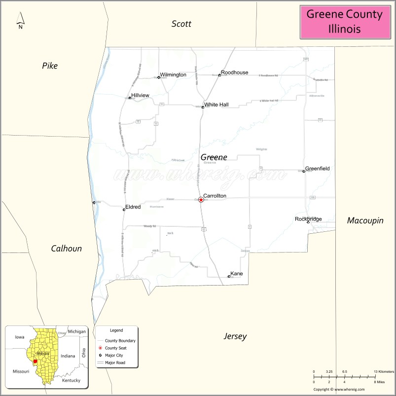
About Greene County Map, Illinois: The map showing the county boundary, county seat, major cities, highways, water bodies and neighbouring counties.
Most Viewed Illinois Links
Greene County, Illinois
Greene County is a county located in the U.S. state of Illinois. It's county seat is Carrollton. As per 2020 census, the population of Greene County is 11843 people and population density is square miles. According to the United States Census Bureau, the county has a total area of 543 sq mi (1,406 km2). Greene County was established on 1821.
Facts about Greene County, Illinois
| Country | United States |
| State | Illinois |
| Region | West Central Illinois |
| County Seat | Carrollton |
| Named After | Nathanael Greene |
| Established | 1821 |
| Organized | 1821 |
| Coordinates | 39.36° N, 90.39° W |
| Total Area | ~546 sq mi |
| Land Area | ~543 sq mi |
| Water Area | ~3 sq mi |
| Population (2020) | ~11,903 |
| Population Rank | Small-sized county in Illinois |
| Largest City | Carrollton |
| Main Industries | Agriculture, Manufacturing, Government Services |
| Major Rivers | Illinois River, Macoupin Creek |
| Time Zone | Central Time (UTC−06:00) |
| Known For | Illinois River valley, rural farmland, historic small towns |
| Website | https://www.greenecountyil.org |
Ctities in Greene county
| City Name | Type | Population (2020) | Pop. Density | Area |
|---|---|---|---|---|
| Carrollton | City | 2,485 | 1,306.5/sq mi (504.4/km2) | 1.902 sq mi (4.93 km2) |
| Eldred | Village | 149 | 1,111.9/sq mi (429.3/km2) | 0.134 sq mi (0.35 km2) |
| Greenfield | City | 1,059 | 617.9/sq mi (238.6/km2) | 1.714 sq mi (4.44 km2) |
| Hillview | Village | 94 | 115.2/sq mi (44.5/km2) | 0.816 sq mi (2.11 km2) |
| Kane | Village | 296 | 544.1/sq mi (210.1/km2) | 0.544 sq mi (1.41 km2) |
| Rockbridge | Village | 175 | 237.4/sq mi (91.7/km2) | 0.737 sq mi (1.91 km2) |
| Roodhouse | City | 1,578 | 1,400.2/sq mi (540.6/km2) | 1.127 sq mi (2.92 km2) |
| White Hall | City | 2,295 | 890.6/sq mi (343.9/km2) | 2.577 sq mi (6.67 km2) |
| Wilmington | Village | 91 | 115.8/sq mi (44.7/km2) | 0.786 sq mi (2.04 km2) |
Roads and Highways in Greene County, Illinois
Greene County is connected by several key highways that provide access to west-central Illinois and nearby river communities.
- Illinois Route 67 – runs north-south through the county, connecting Carrollton to Jacksonville and Jerseyville
- Illinois Route 108 – runs east-west, linking Carrollton to Jerseyville and Kampsville
- Illinois Route 100 – follows the Illinois River, connecting the county to scenic river towns
- Illinois Route 267 – runs north-south, connecting Greenfield to Jacksonville and Medora
Neighboring Counties of Greene County
- Scott County (north)
- Morgan County (east)
- Macoupin County (southeast)
- Jersey County (south)
- Calhoun County (west)
- Pike County (northwest)
Top Attractions in Greene County, Illinois
Greene County offers scenic countryside, historic sites, and small-town charm along the Illinois River region.
- Carrollton Historic Square – A charming downtown area with historic buildings and local shops.
- Greene County Courthouse – A historic landmark located in Carrollton.
- Roodhouse Railroad Park – Highlights local railroad history and community heritage.
- Hillview Park – A peaceful park with open green space and recreational facilities.
- Illinois River Scenic Areas – Offer beautiful views and opportunities for outdoor activities.
- Greenfield City Park – A community park with playgrounds and picnic areas.
- Greene County Fairgrounds – Hosts annual fairs and local events.
Distance from Greene County to Nearby Cities
- Carrollton to Jacksonville – 25 mi (40 km)
- Carrollton to Springfield – 70 mi (113 km)
- Carrollton to St. Louis – 70 mi (113 km)
- Carrollton to Quincy – 85 mi (137 km)
- Carrollton to Alton – 50 mi (80 km)
FAQs about Greene County
Greene County is located in west-central Illinois, near the Illinois River.
The county is known for its scenic countryside, historic towns, and river landscapes.
Carrollton is the county seat and the main community in Greene County.
Yes, visitors can enjoy parks, river views, and outdoor recreational areas throughout the county.
Greene County is accessible via Illinois Routes 67, 108, 100, and 267.
- Adams County Map
- Alexander County Map
- Bond County Map
- Boone County Map
- Brown County Map
- Bureau County Map
- Calhoun County Map
- Carroll County Map
- Cass County Map
- Champaign County Map
- Christian County Map
- Clark County Map
- Clay County Map
- Clinton County Map
- Coles County Map
- Cook County Map
- Crawford County Map
- Cumberland County Map
- DeKalb County Map
- DeWitt County Map
- Douglas County Map
- DuPage County Map
- Edgar County Map
- Edwards County Map
- Effingham County Map
- Fayette County Map
- Ford County Map
- Franklin County Map
- Fulton County Map
- Gallatin County Map
- Greene County Map
- Grundy County Map
- Hamilton County Map
- Hancock County Map
- Hardin County Map
- Henderson County Map
- Henry County Map
- Iroquois County Map
- Jackson County Map
- Jasper County Map
- Jefferson County Map
- Jersey County Map
- Jo Daviess County Map
- Johnson County Map
- Kane County Map
- Kankakee County Map
- Kendall County Map
- Knox County Map
- Lake County Map
- LaSalle County Map
- Lawrence County Map
- Lee County Map
- Livingston County Map
- Logan County Map
- McDonough County Map
- McHenry County Map
- McLean County Map
- Macon County Map
- Macoupin County Map
- Madison County Map
- Marion County Map
- Marshall County Map
- Mason County Map
- Massac County Map
- Menard County Map
- Mercer County Map
- Monroe County Map
- Montgomery County Map
- Morgan County Map
- Moultrie County Map
- Ogle County Map
- Peoria County Map
- Perry County Map
- Piatt County Map
- Pike County Map
- Pope County Map
- Pulaski County Map
- Putnam County Map
- Randolph County Map
- Richland County Map
- Rock Island County Map
- St Clair County Map
- Saline County Map
- Sangamon County Map
- Schuyler County Map
- Scott County Map
- Shelby County Map
- Stark County Map
- Stephenson County Map
- Tazewell County Map
- Union County Map
- Vermilion County Map
- Wabash County Map
- Warren County Map
- Washington County Map
- Wayne County Map
- White County Map
- Whiteside County Map
- Will County Map
- Williamson County Map
- Winnebago County Map
- Woodford County Map
- Alabama Counties
- Alaska boroughs
- Arizona Counties
- Arkansas Counties
- California County Map
- Colorado Counties
- Connecticut Counties
- Delaware Counties
- Florida County Map
- Georgia County Map
- Hawaii Counties
- Idaho Counties
- Illinois Counties
- Indiana Counties
- Iowa Counties
- Kansas Counties
- Kentucky Counties
- Louisiana Counties
- Maine Counties
- Maryland Counties
- Massachusetts Counties
- Michigan County Map
- Minnesota Counties
- Mississippi Counties
- Missouri Counties
- Montana Counties
- Nebraska Counties
- Nevada Counties
- New York Counties
- New Hampshire Counties
- New Jersey Counties
- New Mexico Counties
- North Carolina Counties
- North Dakota Counties
- Ohio County Map
- Oklahoma Counties
- Oregon Counties
- Pennsylvania Counties
- Rhode Island Counties
- South Carolina Counties
- South Dakota Counties
- Map of Tennessee
- Texas County Map
- Utah Counties
- Vermont Counties
- Virginia Counties
- Washington Counties
- West Virginia Counties
- Wisconsin Counties
- Wyoming Counties