Map of Alexander County - Alexander County is a county located in the U.S. state of Illinois. Alexander County Map showing cities, highways, important places and water bodies. Get Where is Alexander County located in the map, major cities in Alexander county, population, areas, and places of interest.
Alexander County Map, Illinois
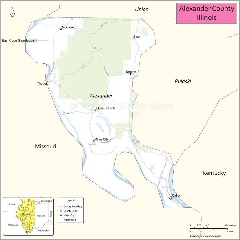
About Alexander County Map, Illinois: The map showing the county boundary, county seat, major cities, highways, water bodies and neighbouring counties.
Most Viewed Illinois Links
Alexander County, Illinois
Alexander County is a county located in the U.S. state of Illinois. It's county seat is Cairo. As per 2020 census, the population of Alexander County is 5030 people and population density is square miles. According to the United States Census Bureau, the county has a total area of 236 sq mi (611 km2). Alexander County was established on 1819.
Facts about Alexander County, Illinois
| Country | United States |
| State | Illinois |
| Region | Southern Illinois (Little Egypt) |
| County Seat | Cairo |
| Named After | Dr. William M. Alexander |
| Established | 1819 |
| Organized | 1819 |
| Coordinates | 37.15° N, 89.34° W |
| Total Area | ~236 sq mi |
| Land Area | ~222 sq mi |
| Water Area | ~14 sq mi |
| Population (2020) | ~5,616 |
| Population Rank | One of the least populous counties in Illinois |
| Largest City | Cairo |
| Main Industries | Agriculture, River Transportation, Government Services |
| Major Rivers | Mississippi River, Ohio River |
| Time Zone | Central Time (UTC−06:00) |
| Known For | Confluence of the Mississippi and Ohio Rivers, historic river town of Cairo |
| Website | https://alexandercounty.illinois.gov |
Ctities in Alexander county
| City Name | Type | Population (2020) | Pop. Density | Area |
|---|---|---|---|---|
| Cairo | City | 1,733 | 248.0/sq mi (95.8/km2) | 6.987 sq mi (18.1 km2) |
| East Cape Girardeau | Village | 289 | 147.4/sq mi (56.9/km2) | 1.961 sq mi (5.08 km2) |
| McClure | Village | 256 | 167.5/sq mi (64.7/km2) | 1.528 sq mi (3.96 km2) |
| Tamms | Village | 430 | 184.4/sq mi (71.2/km2) | 2.332 sq mi (6.04 km2) |
| Thebes | Village | 208 | 119.2/sq mi (46.0/km2) | 1.745 sq mi (4.52 km2) |
Roads and Highways in Alexander County, Illinois
Alexander County is connected by a few key highways that link it to southern Illinois, Missouri, and Kentucky, especially around the Mississippi and Ohio River junction.
- U.S. Route 51 – runs north-south, connecting Cairo to Mounds and further into central Illinois
- U.S. Route 60 – crosses east-west through the southern part of the county, linking Missouri to Kentucky
- U.S. Route 62 – runs east-west alongside US 60, connecting Cairo to nearby towns and states
- Illinois Route 3 – runs north-south along the Mississippi River, linking the county to Union County
Neighboring Counties of Alexander County
- Union County (north)
- Pulaski County (northeast)
- Ballard County, Kentucky (east)
- Mississippi County, Missouri (west)
- Scott County, Missouri (northwest)
Top Attractions in Alexander County, Illinois
Alexander County offers unique river views, historic landmarks, and quiet natural areas at the southernmost point of Illinois.
- Cairo Historic District – Features historic buildings and sites tied to the town’s riverfront past.
- Fort Defiance Park – Located at the meeting point of the Mississippi and Ohio Rivers with scenic views.
- Magnolia Manor – A historic home in Cairo reflecting 19th-century architecture.
- Cache River Wetlands – Offers wildlife viewing, birdwatching, and peaceful natural surroundings.
- Ohio River Scenic Views – Great for photography and relaxing by the water.
- Mississippi River Levee Areas – Popular for walking and enjoying river landscapes.
- Alexander County Courthouse – A historic building in Cairo with classic design.
Distance from Alexander County to Nearby Cities
- Cairo to Carbondale – 55 mi (89 km)
- Cairo to Cape Girardeau – 20 mi (32 km)
- Cairo to Paducah – 35 mi (56 km)
- Cairo to St. Louis – 165 mi (266 km)
- Cairo to Memphis – 180 mi (290 km)
FAQs about Alexander County
Alexander County is located in the southern tip of Illinois at the meeting point of the Mississippi and Ohio Rivers.
The county is known for its unique river confluence, historic sites, and scenic natural areas.
Cairo is the county seat and the largest city in Alexander County.
Yes, visitors can enjoy fishing, boating, birdwatching, and exploring riverfront areas.
Alexander County is accessible via U.S. Routes 51, 60, and 62, along with nearby state highways.
- Adams County Map
- Alexander County Map
- Bond County Map
- Boone County Map
- Brown County Map
- Bureau County Map
- Calhoun County Map
- Carroll County Map
- Cass County Map
- Champaign County Map
- Christian County Map
- Clark County Map
- Clay County Map
- Clinton County Map
- Coles County Map
- Cook County Map
- Crawford County Map
- Cumberland County Map
- DeKalb County Map
- DeWitt County Map
- Douglas County Map
- DuPage County Map
- Edgar County Map
- Edwards County Map
- Effingham County Map
- Fayette County Map
- Ford County Map
- Franklin County Map
- Fulton County Map
- Gallatin County Map
- Greene County Map
- Grundy County Map
- Hamilton County Map
- Hancock County Map
- Hardin County Map
- Henderson County Map
- Henry County Map
- Iroquois County Map
- Jackson County Map
- Jasper County Map
- Jefferson County Map
- Jersey County Map
- Jo Daviess County Map
- Johnson County Map
- Kane County Map
- Kankakee County Map
- Kendall County Map
- Knox County Map
- Lake County Map
- LaSalle County Map
- Lawrence County Map
- Lee County Map
- Livingston County Map
- Logan County Map
- McDonough County Map
- McHenry County Map
- McLean County Map
- Macon County Map
- Macoupin County Map
- Madison County Map
- Marion County Map
- Marshall County Map
- Mason County Map
- Massac County Map
- Menard County Map
- Mercer County Map
- Monroe County Map
- Montgomery County Map
- Morgan County Map
- Moultrie County Map
- Ogle County Map
- Peoria County Map
- Perry County Map
- Piatt County Map
- Pike County Map
- Pope County Map
- Pulaski County Map
- Putnam County Map
- Randolph County Map
- Richland County Map
- Rock Island County Map
- St Clair County Map
- Saline County Map
- Sangamon County Map
- Schuyler County Map
- Scott County Map
- Shelby County Map
- Stark County Map
- Stephenson County Map
- Tazewell County Map
- Union County Map
- Vermilion County Map
- Wabash County Map
- Warren County Map
- Washington County Map
- Wayne County Map
- White County Map
- Whiteside County Map
- Will County Map
- Williamson County Map
- Winnebago County Map
- Woodford County Map
- Alabama Counties
- Alaska boroughs
- Arizona Counties
- Arkansas Counties
- California County Map
- Colorado Counties
- Connecticut Counties
- Delaware Counties
- Florida County Map
- Georgia County Map
- Hawaii Counties
- Idaho Counties
- Illinois Counties
- Indiana Counties
- Iowa Counties
- Kansas Counties
- Kentucky Counties
- Louisiana Counties
- Maine Counties
- Maryland Counties
- Massachusetts Counties
- Michigan County Map
- Minnesota Counties
- Mississippi Counties
- Missouri Counties
- Montana Counties
- Nebraska Counties
- Nevada Counties
- New York Counties
- New Hampshire Counties
- New Jersey Counties
- New Mexico Counties
- North Carolina Counties
- North Dakota Counties
- Ohio County Map
- Oklahoma Counties
- Oregon Counties
- Pennsylvania Counties
- Rhode Island Counties
- South Carolina Counties
- South Dakota Counties
- Map of Tennessee
- Texas County Map
- Utah Counties
- Vermont Counties
- Virginia Counties
- Washington Counties
- West Virginia Counties
- Wisconsin Counties
- Wyoming Counties