Map of Johnson County - Johnson County is a county located in the U.S. state of Illinois. Johnson County Map showing cities, highways, important places and water bodies. Get Where is Johnson County located in the map, major cities in Johnson county, population, areas, and places of interest.
Johnson County Map, Illinois
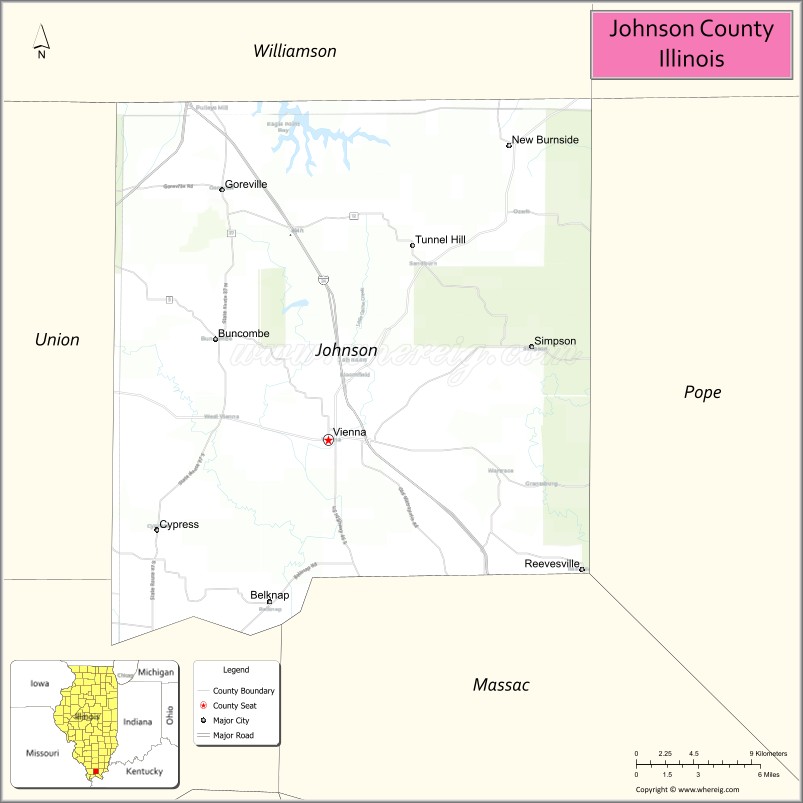
About Johnson County Map, Illinois: The map showing the county boundary, county seat, major cities, highways, water bodies and neighbouring counties.
Most Viewed Illinois Links
Johnson County, Illinois
Johnson County is a county located in the U.S. state of Illinois. It's county seat is Vienna. As per 2020 census, the population of Johnson County is 13463 people and population density is square miles. According to the United States Census Bureau, the county has a total area of 343 sq mi (888 km2). Johnson County was established on 1812.
Facts about Johnson County, Illinois
| Country | United States |
| State | Illinois |
| Region | Southern Illinois |
| County Seat | Vienna |
| Named After | Richard Mentor Johnson |
| Established | 1812 |
| Organized | 1812 |
| Coordinates | 37.46° N, 88.88° W |
| Total Area | ~344 sq mi |
| Land Area | ~343 sq mi |
| Water Area | ~1 sq mi |
| Population (2020) | ~12,582 |
| Population Rank | Small-sized county in Illinois |
| Largest City | Vienna |
| Main Industries | Agriculture, Manufacturing, Government Services, Tourism |
| Major Highways | Interstate 24, Illinois Route 37 |
| Time Zone | Central Time (UTC−06:00) |
| Known For | Shawnee National Forest nearby, outdoor recreation, rural landscapes |
| Website | https://www.johnsoncountyil.gov |
Ctities in Johnson county
| City Name | Type | Population (2020) | Pop. Density | Area |
|---|---|---|---|---|
| Belknap | Village | 88 | 83.3/sq mi (32.1/km2) | 1.057 sq mi (2.74 km2) |
| Buncombe | Village | 207 | 174.4/sq mi (67.3/km2) | 1.187 sq mi (3.07 km2) |
| Cypress | Village | 217 | 288.2/sq mi (111.3/km2) | 0.753 sq mi (1.95 km2) |
| Goreville | Village | 1,068 | 397.6/sq mi (153.5/km2) | 2.686 sq mi (6.96 km2) |
| New Burnside | Village | 153 | 146.4/sq mi (56.5/km2) | 1.045 sq mi (2.71 km2) |
| Simpson | Village | 44 | 83.8/sq mi (32.4/km2) | 0.525 sq mi (1.36 km2) |
| Vienna | City | 1,343 | 473.4/sq mi (182.8/km2) | 2.837 sq mi (7.35 km2) |
Roads and Highways in Johnson County, Illinois
Johnson County is connected by scenic highways that provide access to southern Illinois and the Shawnee National Forest region.
- Interstate 24 – runs northeast-southwest through the county, connecting Vienna to Paducah and Metropolis
- Illinois Route 146 – runs east-west, linking Vienna to Golconda and Anna
- Illinois Route 37 – runs north-south, connecting the county to Marion and Metropolis
- Illinois Route 147 – serves local communities, connecting Vienna to Simpson and Tunnel Hill
Neighboring Counties of Johnson County
- Williamson County (north)
- Saline County (northeast)
- Pope County (east)
- Massac County (south)
- Union County (west)
Top Attractions in Johnson County, Illinois
Johnson County offers natural beauty, outdoor recreation, and scenic landscapes within the Shawnee National Forest.
- Shawnee National Forest – A major natural attraction with hiking, camping, and wildlife viewing.
- Ferne Clyffe State Park – Known for waterfalls, trails, and scenic rock formations.
- Vienna City Park – A community park with playgrounds and picnic areas.
- Johnson County Courthouse – A historic building located in Vienna.
- River to River Trail – A popular long-distance hiking trail passing through the county.
- Cache River Wetlands (nearby) – Offers unique ecosystems and wildlife viewing opportunities.
- Tunnel Hill State Trail (nearby) – A trail for biking and walking with scenic views.
Distance from Johnson County to Nearby Cities
- Vienna to Carbondale – 35 mi (56 km)
- Vienna to Paducah – 45 mi (72 km)
- Vienna to Marion – 25 mi (40 km)
- Vienna to Cape Girardeau – 70 mi (113 km)
- Vienna to St. Louis – 140 mi (225 km)
FAQs about Johnson County
Johnson County is located in southern Illinois, within the Shawnee National Forest region.
The county is known for its natural beauty, state parks, and outdoor recreation opportunities.
Vienna is the county seat and main community in Johnson County.
Yes, visitors can enjoy hiking, camping, trails, and scenic natural areas throughout the county.
Johnson County is accessible via Interstate 24 and several Illinois state highways including Routes 146, 37, and 147.
- Adams County Map
- Alexander County Map
- Bond County Map
- Boone County Map
- Brown County Map
- Bureau County Map
- Calhoun County Map
- Carroll County Map
- Cass County Map
- Champaign County Map
- Christian County Map
- Clark County Map
- Clay County Map
- Clinton County Map
- Coles County Map
- Cook County Map
- Crawford County Map
- Cumberland County Map
- DeKalb County Map
- DeWitt County Map
- Douglas County Map
- DuPage County Map
- Edgar County Map
- Edwards County Map
- Effingham County Map
- Fayette County Map
- Ford County Map
- Franklin County Map
- Fulton County Map
- Gallatin County Map
- Greene County Map
- Grundy County Map
- Hamilton County Map
- Hancock County Map
- Hardin County Map
- Henderson County Map
- Henry County Map
- Iroquois County Map
- Jackson County Map
- Jasper County Map
- Jefferson County Map
- Jersey County Map
- Jo Daviess County Map
- Johnson County Map
- Kane County Map
- Kankakee County Map
- Kendall County Map
- Knox County Map
- Lake County Map
- LaSalle County Map
- Lawrence County Map
- Lee County Map
- Livingston County Map
- Logan County Map
- McDonough County Map
- McHenry County Map
- McLean County Map
- Macon County Map
- Macoupin County Map
- Madison County Map
- Marion County Map
- Marshall County Map
- Mason County Map
- Massac County Map
- Menard County Map
- Mercer County Map
- Monroe County Map
- Montgomery County Map
- Morgan County Map
- Moultrie County Map
- Ogle County Map
- Peoria County Map
- Perry County Map
- Piatt County Map
- Pike County Map
- Pope County Map
- Pulaski County Map
- Putnam County Map
- Randolph County Map
- Richland County Map
- Rock Island County Map
- St Clair County Map
- Saline County Map
- Sangamon County Map
- Schuyler County Map
- Scott County Map
- Shelby County Map
- Stark County Map
- Stephenson County Map
- Tazewell County Map
- Union County Map
- Vermilion County Map
- Wabash County Map
- Warren County Map
- Washington County Map
- Wayne County Map
- White County Map
- Whiteside County Map
- Will County Map
- Williamson County Map
- Winnebago County Map
- Woodford County Map
- Alabama Counties
- Alaska boroughs
- Arizona Counties
- Arkansas Counties
- California County Map
- Colorado Counties
- Connecticut Counties
- Delaware Counties
- Florida County Map
- Georgia County Map
- Hawaii Counties
- Idaho Counties
- Illinois Counties
- Indiana Counties
- Iowa Counties
- Kansas Counties
- Kentucky Counties
- Louisiana Counties
- Maine Counties
- Maryland Counties
- Massachusetts Counties
- Michigan County Map
- Minnesota Counties
- Mississippi Counties
- Missouri Counties
- Montana Counties
- Nebraska Counties
- Nevada Counties
- New York Counties
- New Hampshire Counties
- New Jersey Counties
- New Mexico Counties
- North Carolina Counties
- North Dakota Counties
- Ohio County Map
- Oklahoma Counties
- Oregon Counties
- Pennsylvania Counties
- Rhode Island Counties
- South Carolina Counties
- South Dakota Counties
- Map of Tennessee
- Texas County Map
- Utah Counties
- Vermont Counties
- Virginia Counties
- Washington Counties
- West Virginia Counties
- Wisconsin Counties
- Wyoming Counties