Map of Schuyler County - Schuyler County is a county located in the U.S. state of Illinois. Schuyler County Map showing cities, highways, important places and water bodies. Get Where is Schuyler County located in the map, major cities in Schuyler county, population, areas, and places of interest.
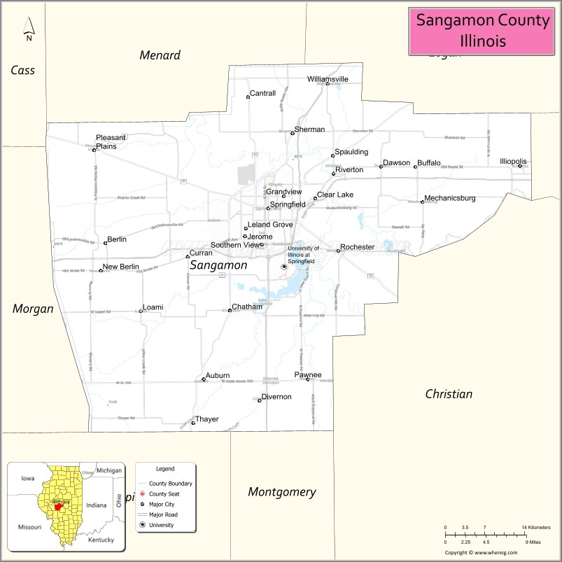
Sangamon County Map, Illinois
About Schuyler County Map, Illinois: The map showing the county boundary, county seat, major cities, highways, water bodies and neighbouring counties.
Most Viewed Illinois Links
Sangamon County, Illinois
Sangamon County is a county located in the U.S. state of Illinois. It's county seat is Springfield. As per 2020 census, the population of Sangamon County is 194734 people and population density is square miles. According to the United States Census Bureau, the county has a total area of 868 sq mi (2,248 km2). Sangamon County was established on 1821.
Facts about Sangamon County, Illinois
| Country | United States |
| State | Illinois |
| Region | Central Illinois |
| County Seat | Springfield |
| Named After | Sangamon River |
| Established | 1821 |
| Organized | 1821 |
| Coordinates | 39.78° N, 89.65° W |
| Total Area | ~876 sq mi |
| Land Area | ~868 sq mi |
| Water Area | ~8 sq mi |
| Population (2020) | ~196,343 |
| Population Rank | Fifth-most populous county in Illinois |
| Largest City | Springfield |
| Main Industries | Government, Healthcare, Education, Insurance |
| Major Highways | Interstate 55, Interstate 72, Interstate 155 |
| Time Zone | Central Time (UTC−06:00) |
| Known For | Illinois state capital, Abraham Lincoln heritage, Lake Springfield |
| Website | https://www.sangamonil.gov |
Ctities in Sangamon county
| City Name | Type | Population (2020) | Pop. Density | Area |
|---|---|---|---|---|
| Virden | City | 3,231 | 1,710.4/sq mi (660.4/km2) | 1.889 sq mi (4.89 km2) |
| Auburn | City | 4,574 | 1,109.1/sq mi (428.2/km2) | 4.124 sq mi (10.68 km2) |
| Berlin | Village | 141 | 158.2/sq mi (61.1/km2) | 0.891 sq mi (2.31 km2) |
| Buffalo | Village | 447 | 1,295.7/sq mi (500.3/km2) | 0.345 sq mi (0.89 km2) |
| Cantrall | Village | 144 | 576.0/sq mi (222.4/km2) | 0.25 sq mi (0.65 km2) |
| Chatham | Village | 14,377 | 1,952.3/sq mi (753.8/km2) | 7.364 sq mi (19.07 km2) |
| Clear Lake | Village | 203 | 2,206.5/sq mi (851.9/km2) | 0.092 sq mi (0.24 km2) |
| Curran | Village | 213 | 107.8/sq mi (41.6/km2) | 1.975 sq mi (5.12 km2) |
| Dawson | Village | 519 | 655.3/sq mi (253.0/km2) | 0.792 sq mi (2.05 km2) |
| Divernon | Village | 1,139 | 1,492.8/sq mi (576.4/km2) | 0.763 sq mi (1.98 km2) |
| Grandview | Village | 1,405 | 4,194.0/sq mi (1,619.3/km2) | 0.335 sq mi (0.87 km2) |
| Illiopolis | Village | 846 | 1,249.6/sq mi (482.5/km2) | 0.677 sq mi (1.75 km2) |
| Jerome | Village | 1,692 | 3,662.3/sq mi (1,414.0/km2) | 0.462 sq mi (1.2 km2) |
| Leland Grove | City | 1,454 | 2,315.3/sq mi (893.9/km2) | 0.628 sq mi (1.63 km2) |
| Loami | Village | 812 | 802.4/sq mi (309.8/km2) | 1.012 sq mi (2.62 km2) |
| Mechanicsburg | Village | 662 | 639.0/sq mi (246.7/km2) | 1.036 sq mi (2.68 km2) |
| New Berlin | Village | 1,381 | 1,222.1/sq mi (471.9/km2) | 1.13 sq mi (2.93 km2) |
| Pawnee | Village | 2,678 | 2,010.5/sq mi (776.3/km2) | 1.332 sq mi (3.45 km2) |
| Pleasant Plains | Village | 808 | 605.2/sq mi (233.7/km2) | 1.335 sq mi (3.46 km2) |
| Riverton | Village | 3,532 | 1,131.7/sq mi (436.9/km2) | 3.121 sq mi (8.08 km2) |
| Rochester | Village | 3,863 | 1,459.9/sq mi (563.7/km2) | 2.646 sq mi (6.85 km2) |
| Sherman | Village | 4,673 | 1,494.4/sq mi (577.0/km2) | 3.127 sq mi (8.1 km2) |
| Southern View | Village | 1,596 | 2,466.8/sq mi (952.4/km2) | 0.647 sq mi (1.68 km2) |
| Spaulding | Village | 801 | 1,068.0/sq mi (412.4/km2) | 0.75 sq mi (1.94 km2) |
| Springfield[c] | City | 114,394 | 1,871.1/sq mi (722.4/km2) | 61.138 sq mi (158.35 km2) |
| Thayer | Village | 632 | 1,036.1/sq mi (400.0/km2) | 0.61 sq mi (1.58 km2) |
| Williamsville | Village | 1,425 | 920.5/sq mi (355.4/km2) | 1.548 sq mi (4.01 km2) |
Roads and Highways in Sangamon County, Illinois
Sangamon County is a major transportation hub in central Illinois, centered around the state capital of Springfield.
- Interstate 55 – runs north-south through the county, connecting Springfield to Chicago and St. Louis
- Interstate 72 – runs east-west, linking Springfield to Decatur and Quincy
- Interstate 72 Business Loop – serves downtown Springfield and surrounding areas
- U.S. Route 36 – runs east-west, connecting Springfield to Decatur and Jacksonville
- Illinois Route 4 – runs north-south, linking Springfield to Carlinville and Beardstown
- Illinois Route 29 – runs north-south, connecting Springfield to Athens and Petersburg
Neighboring Counties of Sangamon County
- Menard County (northwest)
- Mason County (north)
- Logan County (northeast)
- Christian County (southeast)
- Montgomery County (south)
- Macoupin County (southwest)
- Morgan County (west)
Top Attractions in Sangamon County, Illinois
Sangamon County offers historic landmarks, cultural attractions, and outdoor spaces centered around Springfield.
- Abraham Lincoln Presidential Library and Museum – A major historical attraction dedicated to Abraham Lincoln.
- Lincoln Home National Historic Site – Preserves the home of Abraham Lincoln.
- Illinois State Capitol – The seat of government with impressive architecture.
- Washington Park Botanical Garden – Features beautiful gardens and walking paths.
- Henson Robinson Zoo – A family-friendly zoo with a variety of animals.
- Lake Springfield – Offers boating, fishing, and outdoor recreation.
- Old State Capitol State Historic Site – A historic building where Lincoln once served.
Distance from Sangamon County to Nearby Cities
- Springfield to Decatur – 40 mi (64 km)
- Springfield to Peoria – 75 mi (121 km)
- Springfield to St. Louis – 100 mi (161 km)
- Springfield to Champaign – 90 mi (145 km)
- Springfield to Chicago – 200 mi (322 km)
FAQs about Sangamon County
Sangamon County is located in central Illinois, centered around the state capital city of Springfield.
The county is known for its connection to Abraham Lincoln, historic landmarks, and its role as the state capital region.
Springfield is the county seat and the capital of Illinois.
Yes, visitors can enjoy parks, gardens, lakes, and outdoor recreation throughout the county.
Sangamon County is accessible via Interstates 55 and 72, along with several U.S. and state highways.
- Adams County Map
- Alexander County Map
- Bond County Map
- Boone County Map
- Brown County Map
- Bureau County Map
- Calhoun County Map
- Carroll County Map
- Cass County Map
- Champaign County Map
- Christian County Map
- Clark County Map
- Clay County Map
- Clinton County Map
- Coles County Map
- Cook County Map
- Crawford County Map
- Cumberland County Map
- DeKalb County Map
- DeWitt County Map
- Douglas County Map
- DuPage County Map
- Edgar County Map
- Edwards County Map
- Effingham County Map
- Fayette County Map
- Ford County Map
- Franklin County Map
- Fulton County Map
- Gallatin County Map
- Greene County Map
- Grundy County Map
- Hamilton County Map
- Hancock County Map
- Hardin County Map
- Henderson County Map
- Henry County Map
- Iroquois County Map
- Jackson County Map
- Jasper County Map
- Jefferson County Map
- Jersey County Map
- Jo Daviess County Map
- Johnson County Map
- Kane County Map
- Kankakee County Map
- Kendall County Map
- Knox County Map
- Lake County Map
- LaSalle County Map
- Lawrence County Map
- Lee County Map
- Livingston County Map
- Logan County Map
- McDonough County Map
- McHenry County Map
- McLean County Map
- Macon County Map
- Macoupin County Map
- Madison County Map
- Marion County Map
- Marshall County Map
- Mason County Map
- Massac County Map
- Menard County Map
- Mercer County Map
- Monroe County Map
- Montgomery County Map
- Morgan County Map
- Moultrie County Map
- Ogle County Map
- Peoria County Map
- Perry County Map
- Piatt County Map
- Pike County Map
- Pope County Map
- Pulaski County Map
- Putnam County Map
- Randolph County Map
- Richland County Map
- Rock Island County Map
- St Clair County Map
- Saline County Map
- Sangamon County Map
- Schuyler County Map
- Scott County Map
- Shelby County Map
- Stark County Map
- Stephenson County Map
- Tazewell County Map
- Union County Map
- Vermilion County Map
- Wabash County Map
- Warren County Map
- Washington County Map
- Wayne County Map
- White County Map
- Whiteside County Map
- Will County Map
- Williamson County Map
- Winnebago County Map
- Woodford County Map
- Alabama Counties
- Alaska boroughs
- Arizona Counties
- Arkansas Counties
- California County Map
- Colorado Counties
- Connecticut Counties
- Delaware Counties
- Florida County Map
- Georgia County Map
- Hawaii Counties
- Idaho Counties
- Illinois Counties
- Indiana Counties
- Iowa Counties
- Kansas Counties
- Kentucky Counties
- Louisiana Counties
- Maine Counties
- Maryland Counties
- Massachusetts Counties
- Michigan County Map
- Minnesota Counties
- Mississippi Counties
- Missouri Counties
- Montana Counties
- Nebraska Counties
- Nevada Counties
- New York Counties
- New Hampshire Counties
- New Jersey Counties
- New Mexico Counties
- North Carolina Counties
- North Dakota Counties
- Ohio County Map
- Oklahoma Counties
- Oregon Counties
- Pennsylvania Counties
- Rhode Island Counties
- South Carolina Counties
- South Dakota Counties
- Map of Tennessee
- Texas County Map
- Utah Counties
- Vermont Counties
- Virginia Counties
- Washington Counties
- West Virginia Counties
- Wisconsin Counties
- Wyoming Counties