Map of Macoupin County - Macoupin County is a county located in the U.S. state of Illinois. Macoupin County Map showing cities, highways, important places and water bodies. Get Where is Macoupin County located in the map, major cities in Macoupin county, population, areas, and places of interest.
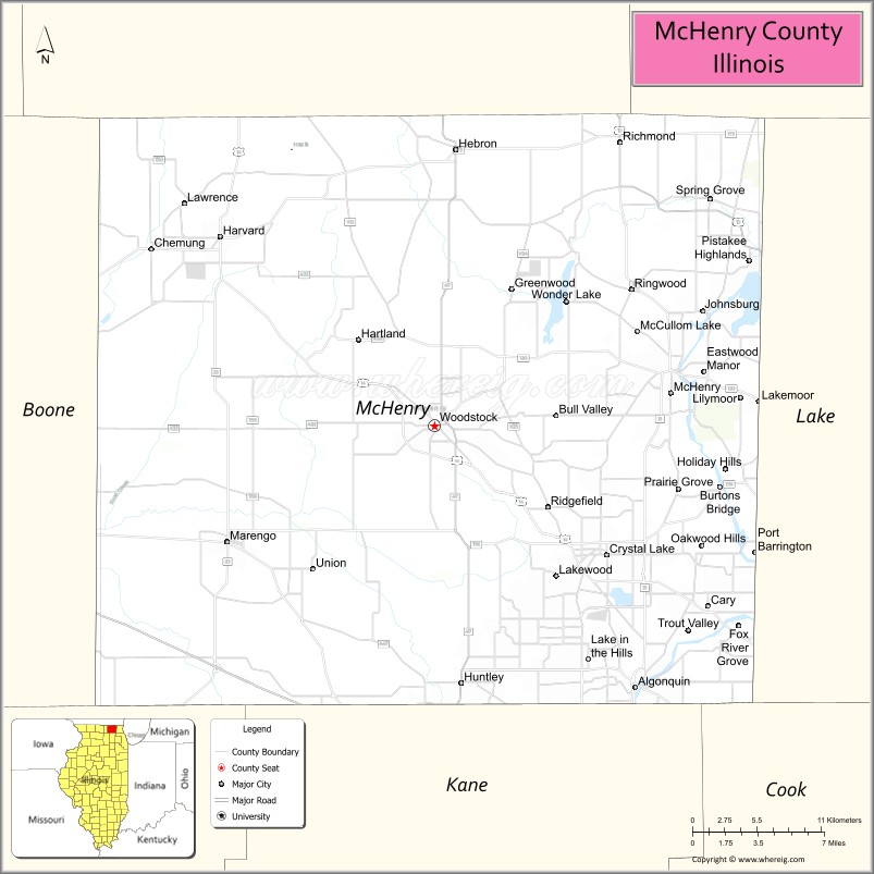
McHenry County Map, Illinois
About Macoupin County Map, Illinois: The map showing the county boundary, county seat, major cities, highways, water bodies and neighbouring counties.
Most Viewed Illinois Links
McHenry County, Illinois
McHenry County is a county located in the U.S. state of Illinois. It's county seat is Woodstock. As per 2020 census, the population of McHenry County is 311122 people and population density is square miles. According to the United States Census Bureau, the county has a total area of 603 sq mi (1,562 km2). McHenry County was established on 1836.
Facts about McHenry County, Illinois
| Country | United States |
| State | Illinois |
| Region | Northern Illinois / Chicagoland |
| County Seat | Woodstock |
| Named After | William McHenry |
| Established | 1836 |
| Organized | 1836 |
| Coordinates | 42.33° N, 88.27° W |
| Total Area | ~611 sq mi |
| Land Area | ~603 sq mi |
| Water Area | ~8 sq mi |
| Population (2020) | ~310,229 |
| Population Rank | Sixth-most populous county in Illinois |
| Largest City | Crystal Lake |
| Main Industries | Manufacturing, Healthcare, Retail, Agriculture |
| Major Highways | Interstate 90, U.S. Route 14, Illinois Route 31 |
| Time Zone | Central Time (UTC−06:00) |
| Known For | Historic Woodstock Square, suburban growth, conservation areas |
| Website | https://www.mchenrycountyil.gov |
Ctities in McHenry county
| City Name | Type | Population (2020) | Pop. Density | Area |
|---|---|---|---|---|
| Barrington Hills | Village | 4,114 | 152.3/sq mi (58.8/km2) | 27.004 sq mi (69.94 km2) |
| Fox Lake | Village | 10,978 | 1,401.5/sq mi (541.1/km2) | 7.833 sq mi (20.29 km2) |
| Island Lake | Village | 8,051 | 2,404.7/sq mi (928.5/km2) | 3.348 sq mi (8.67 km2) |
| Bull Valley | Village | 1,128 | 123.6/sq mi (47.7/km2) | 9.128 sq mi (23.64 km2) |
| Cary | Village | 17,826 | 2,860.4/sq mi (1,104.4/km2) | 6.232 sq mi (16.14 km2) |
| Crystal Lake | City | 40,269 | 2,128.6/sq mi (821.9/km2) | 18.918 sq mi (49 km2) |
| Greenwood | Village | 324 | 123.1/sq mi (47.5/km2) | 2.632 sq mi (6.82 km2) |
| Harvard | City | 9,469 | 1,133.3/sq mi (437.6/km2) | 8.355 sq mi (21.64 km2) |
| Hebron | Village | 1,368 | 708.4/sq mi (273.5/km2) | 1.931 sq mi (5 km2) |
| Holiday Hills | Village | 618 | 661.7/sq mi (255.5/km2) | 0.934 sq mi (2.42 km2) |
| Johnsburg | Village | 6,355 | 887.2/sq mi (342.5/km2) | 7.163 sq mi (18.55 km2) |
| Lake in the Hills | Village | 28,982 | 2,840.5/sq mi (1,096.7/km2) | 10.203 sq mi (26.43 km2) |
| Lakewood | Village | 4,283 | 933.7/sq mi (360.5/km2) | 4.587 sq mi (11.88 km2) |
| McCullom Lake | Village | 988 | 2,847.3/sq mi (1,099.3/km2) | 0.347 sq mi (0.9 km2) |
| McHenry | City | 27,135 | 1,871.5/sq mi (722.6/km2) | 14.499 sq mi (37.55 km2) |
| Marengo | City | 7,568 | 886.6/sq mi (342.3/km2) | 8.536 sq mi (22.11 km2) |
| Oakwood Hills | Village | 2,076 | 1,908.1/sq mi (736.7/km2) | 1.088 sq mi (2.82 km2) |
| Prairie Grove | Village | 1,963 | 345.8/sq mi (133.5/km2) | 5.677 sq mi (14.7 km2) |
| Richmond | Village | 2,089 | 486.9/sq mi (188.0/km2) | 4.29 sq mi (11.11 km2) |
| Ringwood | Village | 844 | 218.4/sq mi (84.3/km2) | 3.864 sq mi (10.01 km2) |
| Spring Grove | Village | 5,487 | 606.6/sq mi (234.2/km2) | 9.046 sq mi (23.43 km2) |
| Trout Valley | Village | 515 | 1,203.3/sq mi (464.6/km2) | 0.428 sq mi (1.11 km2) |
| Union | Village | 551 | 659.1/sq mi (254.5/km2) | 0.836 sq mi (2.17 km2) |
| Wonder Lake | Village | 3,973 | 800.4/sq mi (309.0/km2) | 4.964 sq mi (12.86 km2) |
| Woodstock | City | 25,630 | 1,943.6/sq mi (750.4/km2) | 13.187 sq mi (34.15 km2) |
| Algonquin | Village | 29,700 | 2,414.2/sq mi (932.1/km2) | 12.302 sq mi (31.86 km2) |
| Huntley | Village | 27,740 | 1,941.4/sq mi (749.6/km2) | 14.289 sq mi (37.01 km2) |
| Fox River Grove | Village | 4,702 | 2,748.1/sq mi (1,061.0/km2) | 1.711 sq mi (4.43 km2) |
| Lakemoor | Village | 6,182 | 1,174.6/sq mi (453.5/km2) | 5.263 sq mi (13.63 km2) |
| Port Barrington | Village | 1,584 | 1,365.5/sq mi (527.2/km2) | 1.16 sq mi (3 km2) |
Roads and Highways in McHenry County, Illinois
McHenry County is well-connected by major highways that provide access to the Chicago metropolitan area and northern Illinois.
- U.S. Route 14 – runs northwest-southeast, connecting Crystal Lake to Chicago and Woodstock
- U.S. Route 12 – runs north-south, linking the county to Wisconsin and the Chicago suburbs
- Illinois Route 31 – runs north-south along the Fox River, connecting McHenry to Elgin
- Illinois Route 47 – runs north-south, linking Woodstock to Huntley and beyond
- Illinois Route 120 – runs east-west, connecting McHenry to Waukegan and the Lake County area
Neighboring Counties of McHenry County
- Boone County (west)
- Lake County (east)
- Kane County (south)
- DeKalb County (southwest)
- Walworth County, Wisconsin (north)
- Kenosha County, Wisconsin (northeast)
Top Attractions in McHenry County, Illinois
McHenry County offers a mix of lakes, parks, and suburban attractions with access to outdoor recreation.
- Moraine Hills State Park – A scenic park with trails, lakes, and wildlife viewing.
- Chain O’Lakes (nearby) – A popular destination for boating, fishing, and water activities.
- Woodstock Square Historic District – Known for its charming downtown and historic buildings.
- Volo Bog State Natural Area – A unique wetland ecosystem with boardwalk trails.
- McHenry Outdoor Theater – One of the last drive-in theaters in the region.
- Crystal Lake Main Beach – Offers swimming, boating, and lakefront recreation.
- McHenry County Fairgrounds – Hosts fairs, festivals, and community events.
Distance from McHenry County to Nearby Cities
- Woodstock to Chicago – 55 mi (89 km)
- Crystal Lake to Rockford – 45 mi (72 km)
- Woodstock to Milwaukee – 75 mi (121 km)
- McHenry to Waukegan – 30 mi (48 km)
- Crystal Lake to Elgin – 20 mi (32 km)
FAQs about McHenry County
McHenry County is located in northeastern Illinois, northwest of Chicago and near the Wisconsin border.
The county is known for its lakes, parks, historic downtowns, and outdoor recreation opportunities.
Woodstock is the county seat and a historic city in McHenry County.
Yes, visitors can enjoy lakes, trails, parks, and water-based recreation throughout the county.
McHenry County is accessible via U.S. Routes 12 and 14, along with several Illinois state highways.
- Adams County Map
- Alexander County Map
- Bond County Map
- Boone County Map
- Brown County Map
- Bureau County Map
- Calhoun County Map
- Carroll County Map
- Cass County Map
- Champaign County Map
- Christian County Map
- Clark County Map
- Clay County Map
- Clinton County Map
- Coles County Map
- Cook County Map
- Crawford County Map
- Cumberland County Map
- DeKalb County Map
- DeWitt County Map
- Douglas County Map
- DuPage County Map
- Edgar County Map
- Edwards County Map
- Effingham County Map
- Fayette County Map
- Ford County Map
- Franklin County Map
- Fulton County Map
- Gallatin County Map
- Greene County Map
- Grundy County Map
- Hamilton County Map
- Hancock County Map
- Hardin County Map
- Henderson County Map
- Henry County Map
- Iroquois County Map
- Jackson County Map
- Jasper County Map
- Jefferson County Map
- Jersey County Map
- Jo Daviess County Map
- Johnson County Map
- Kane County Map
- Kankakee County Map
- Kendall County Map
- Knox County Map
- Lake County Map
- LaSalle County Map
- Lawrence County Map
- Lee County Map
- Livingston County Map
- Logan County Map
- McDonough County Map
- McHenry County Map
- McLean County Map
- Macon County Map
- Macoupin County Map
- Madison County Map
- Marion County Map
- Marshall County Map
- Mason County Map
- Massac County Map
- Menard County Map
- Mercer County Map
- Monroe County Map
- Montgomery County Map
- Morgan County Map
- Moultrie County Map
- Ogle County Map
- Peoria County Map
- Perry County Map
- Piatt County Map
- Pike County Map
- Pope County Map
- Pulaski County Map
- Putnam County Map
- Randolph County Map
- Richland County Map
- Rock Island County Map
- St Clair County Map
- Saline County Map
- Sangamon County Map
- Schuyler County Map
- Scott County Map
- Shelby County Map
- Stark County Map
- Stephenson County Map
- Tazewell County Map
- Union County Map
- Vermilion County Map
- Wabash County Map
- Warren County Map
- Washington County Map
- Wayne County Map
- White County Map
- Whiteside County Map
- Will County Map
- Williamson County Map
- Winnebago County Map
- Woodford County Map
- Alabama Counties
- Alaska boroughs
- Arizona Counties
- Arkansas Counties
- California County Map
- Colorado Counties
- Connecticut Counties
- Delaware Counties
- Florida County Map
- Georgia County Map
- Hawaii Counties
- Idaho Counties
- Illinois Counties
- Indiana Counties
- Iowa Counties
- Kansas Counties
- Kentucky Counties
- Louisiana Counties
- Maine Counties
- Maryland Counties
- Massachusetts Counties
- Michigan County Map
- Minnesota Counties
- Mississippi Counties
- Missouri Counties
- Montana Counties
- Nebraska Counties
- Nevada Counties
- New York Counties
- New Hampshire Counties
- New Jersey Counties
- New Mexico Counties
- North Carolina Counties
- North Dakota Counties
- Ohio County Map
- Oklahoma Counties
- Oregon Counties
- Pennsylvania Counties
- Rhode Island Counties
- South Carolina Counties
- South Dakota Counties
- Map of Tennessee
- Texas County Map
- Utah Counties
- Vermont Counties
- Virginia Counties
- Washington Counties
- West Virginia Counties
- Wisconsin Counties
- Wyoming Counties