Map of Carroll County - Carroll County is a county located in the U.S. state of Illinois. Carroll County Map showing cities, highways, important places and water bodies. Get Where is Carroll County located in the map, major cities in Carroll county, population, areas, and places of interest.
Carroll County Map, Illinois
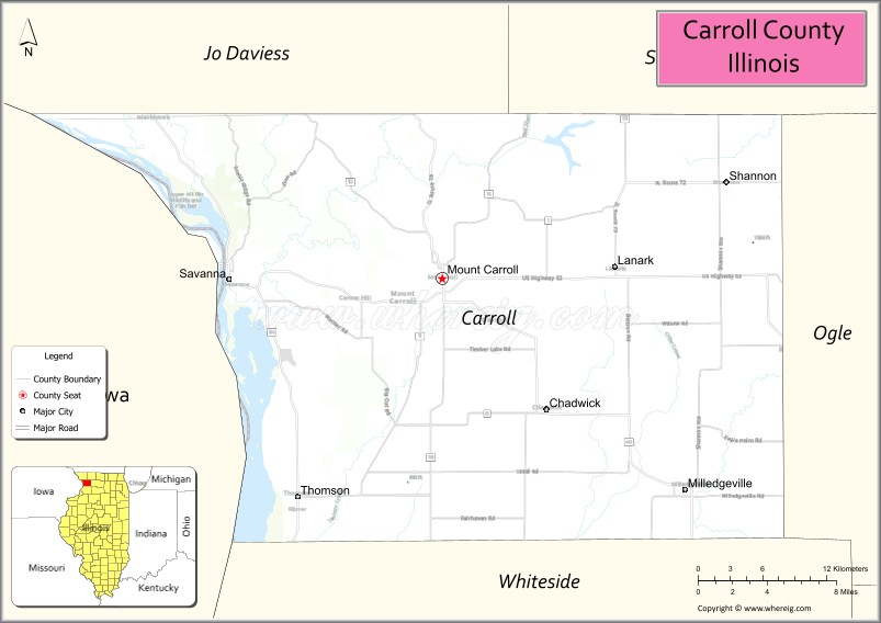
About Carroll County Map, Illinois: The map showing the county boundary, county seat, major cities, highways, water bodies and neighbouring counties.
Most Viewed Illinois Links
Carroll County, Illinois
Carroll County is a county located in the U.S. state of Illinois. It's county seat is Mount Carroll. As per 2020 census, the population of Carroll County is 15698 people and population density is square miles. According to the United States Census Bureau, the county has a total area of 445 sq mi (1,153 km2). Carroll County was established on 1839.
Facts about Carroll County, Illinois
| Country | United States |
| State | Illinois |
| Region | Northwestern Illinois |
| County Seat | Mount Carroll |
| Named After | Charles Carroll of Carrollton |
| Established | 1839 |
| Organized | 1839 |
| Coordinates | 42.09° N, 89.93° W |
| Total Area | ~466 sq mi |
| Land Area | ~445 sq mi |
| Water Area | ~21 sq mi |
| Population (2020) | ~15,702 |
| Population Rank | Small-to-mid-sized county in Illinois |
| Largest City | Savanna |
| Main Industries | Agriculture, Manufacturing, Tourism |
| Major River | Mississippi River |
| Time Zone | Central Time (UTC−06:00) |
| Known For | Mississippi River bluffs, rural scenery, historic Mount Carroll |
| Website | https://www.carroll-county.net |
Ctities in Carroll county
| City Name | Type | Population (2020) | Pop. Density | Area | Incorporated |
|---|---|---|---|---|---|
| Chadwick | Village | 481 | 1,546.6/sq mi (597.2/km2) | 0.311 sq mi (0.81 km2) | |
| Lanark | City | 1,504 | 1,341.7/sq mi (518.0/km2) | 1.121 sq mi (2.9 km2) | |
| Milledgeville | Village | 1,026 | 1,487.0/sq mi (574.1/km2) | 0.69 sq mi (1.79 km2) | |
| Mount Carroll | City | 1,479 | 738.4/sq mi (285.1/km2) | 2.003 sq mi (5.19 km2) | |
| Savanna | City | 2,783 | 1,063.8/sq mi (410.8/km2) | 2.616 sq mi (6.78 km2) | |
| Shannon | Village | 801 | 1,661.8/sq mi (641.6/km2) | 0.482 sq mi (1.25 km2) | |
| Thomson | Village | 1,610 | 725.6/sq mi (280.1/km2) | 2.219 sq mi (5.75 km2) | |
| Albany | 759 | 74 sq mi | 1766 | ||
| Bartlett | 3,200 | 74.9 sq mi | 1790 | ||
| Brookfield | 755 | 22.9 sq mi | 1794 | ||
| Chatham | 341 | 56.7 sq mi | 1767 | ||
| Conway | 9,822 | 69.4 sq mi | 1765 | ||
| Eaton | 405 | 24.3 sq mi | 1766 | ||
| Effingham | 1,691 | 38.4 sq mi | 1778 | ||
| Freedom | 1,689 | 35 sq mi | 1831 | ||
| Hart's Location | 68 | 18.5 sq mi | 1795 | ||
| Jackson | 1,028 | 66.9 sq mi | 1800 | ||
| Madison | 2,565 | 38.5 sq mi | 1852 | ||
| Moultonborough | 4,918 | 59.5 sq mi | 1777 | ||
| Ossipee | 4,372 | 70.8 sq mi | 1785 | ||
| Sandwich | 1,466 | 90.2 sq mi | 1763 | ||
| Tamworth | 2,812 | 59.7 sq mi | 1766 | ||
| Tuftonboro | 2,467 | 41 sq mi | 1795 | ||
| Wakefield | 5,201 | 39.5 sq mi | 1774 | ||
| Wolfeboro | 6,416 | 47.9 sq mi | 1770 |
Roads and Highways in Carroll County, Illinois
Carroll County is connected by scenic highways that follow the Mississippi River and link it to nearby towns and regional destinations in northwestern Illinois.
- U.S. Route 52 – runs east-west through the county, connecting Savanna to Freeport and the Quad Cities region
- Illinois Route 84 – runs north-south along the Mississippi River, linking Savanna to Galena and Fulton
- Illinois Route 78 – runs north-south, connecting Mount Carroll to Stockton and Prophetstown
- Illinois Route 40 – passes through the county, linking Chadwick to Mount Carroll and further south
Neighboring Counties of Carroll County
- Jo Daviess County (north)
- Stephenson County (east)
- Ogle County (southeast)
- Whiteside County (south)
- Clinton County, Iowa (west)
Top Attractions in Carroll County, Illinois
Carroll County offers beautiful river scenery, historic towns, and outdoor recreation along the Mississippi River.
- Mississippi Palisades State Park – Known for its rugged cliffs, hiking trails, and scenic river views.
- Savanna Historic District – Features charming buildings and riverfront views in a small-town setting.
- Mount Carroll Historic District – A well-preserved downtown area with unique shops and historic architecture.
- Timber Lake Playhouse – Illinois’ oldest professional summer theater with live performances.
- Point Rock Park – Offers scenic overlooks of the Mississippi River and surrounding bluffs.
- Carroll County Courthouse – A historic landmark located in Mount Carroll.
- Great River Trail – A popular route for biking and walking along the Mississippi River.
Distance from Carroll County to Nearby Cities
- Mount Carroll to Freeport – 30 mi (48 km)
- Mount Carroll to Rockford – 65 mi (105 km)
- Mount Carroll to Davenport – 60 mi (97 km)
- Mount Carroll to Chicago – 150 mi (241 km)
- Mount Carroll to Dubuque – 55 mi (89 km)
FAQs about Carroll County
Carroll County is located in northwestern Illinois along the Mississippi River, near the borders of Iowa and Wisconsin.
The county is known for its scenic river bluffs, state parks, and historic small towns.
Mount Carroll is the county seat and a historic center of the county.
Yes, visitors can enjoy hiking, biking, and scenic views at parks and along the Mississippi River.
Carroll County is accessible via U.S. Route 52 and several Illinois state highways including Routes 78, 84, and 40.
- Adams County Map
- Alexander County Map
- Bond County Map
- Boone County Map
- Brown County Map
- Bureau County Map
- Calhoun County Map
- Carroll County Map
- Cass County Map
- Champaign County Map
- Christian County Map
- Clark County Map
- Clay County Map
- Clinton County Map
- Coles County Map
- Cook County Map
- Crawford County Map
- Cumberland County Map
- DeKalb County Map
- DeWitt County Map
- Douglas County Map
- DuPage County Map
- Edgar County Map
- Edwards County Map
- Effingham County Map
- Fayette County Map
- Ford County Map
- Franklin County Map
- Fulton County Map
- Gallatin County Map
- Greene County Map
- Grundy County Map
- Hamilton County Map
- Hancock County Map
- Hardin County Map
- Henderson County Map
- Henry County Map
- Iroquois County Map
- Jackson County Map
- Jasper County Map
- Jefferson County Map
- Jersey County Map
- Jo Daviess County Map
- Johnson County Map
- Kane County Map
- Kankakee County Map
- Kendall County Map
- Knox County Map
- Lake County Map
- LaSalle County Map
- Lawrence County Map
- Lee County Map
- Livingston County Map
- Logan County Map
- McDonough County Map
- McHenry County Map
- McLean County Map
- Macon County Map
- Macoupin County Map
- Madison County Map
- Marion County Map
- Marshall County Map
- Mason County Map
- Massac County Map
- Menard County Map
- Mercer County Map
- Monroe County Map
- Montgomery County Map
- Morgan County Map
- Moultrie County Map
- Ogle County Map
- Peoria County Map
- Perry County Map
- Piatt County Map
- Pike County Map
- Pope County Map
- Pulaski County Map
- Putnam County Map
- Randolph County Map
- Richland County Map
- Rock Island County Map
- St Clair County Map
- Saline County Map
- Sangamon County Map
- Schuyler County Map
- Scott County Map
- Shelby County Map
- Stark County Map
- Stephenson County Map
- Tazewell County Map
- Union County Map
- Vermilion County Map
- Wabash County Map
- Warren County Map
- Washington County Map
- Wayne County Map
- White County Map
- Whiteside County Map
- Will County Map
- Williamson County Map
- Winnebago County Map
- Woodford County Map
- Alabama Counties
- Alaska boroughs
- Arizona Counties
- Arkansas Counties
- California County Map
- Colorado Counties
- Connecticut Counties
- Delaware Counties
- Florida County Map
- Georgia County Map
- Hawaii Counties
- Idaho Counties
- Illinois Counties
- Indiana Counties
- Iowa Counties
- Kansas Counties
- Kentucky Counties
- Louisiana Counties
- Maine Counties
- Maryland Counties
- Massachusetts Counties
- Michigan County Map
- Minnesota Counties
- Mississippi Counties
- Missouri Counties
- Montana Counties
- Nebraska Counties
- Nevada Counties
- New York Counties
- New Hampshire Counties
- New Jersey Counties
- New Mexico Counties
- North Carolina Counties
- North Dakota Counties
- Ohio County Map
- Oklahoma Counties
- Oregon Counties
- Pennsylvania Counties
- Rhode Island Counties
- South Carolina Counties
- South Dakota Counties
- Map of Tennessee
- Texas County Map
- Utah Counties
- Vermont Counties
- Virginia Counties
- Washington Counties
- West Virginia Counties
- Wisconsin Counties
- Wyoming Counties