Map of Washington County - Washington County is a county located in the U.S. state of Illinois. Washington County Map showing cities, highways, important places and water bodies. Get Where is Washington County located in the map, major cities in Washington county, population, areas, and places of interest.
Washington County Map, Illinois
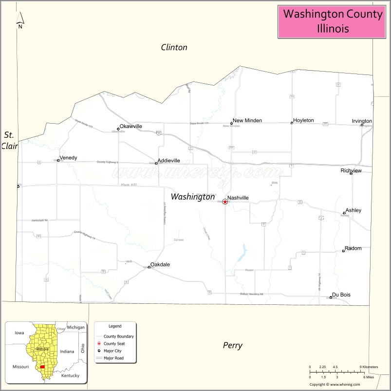
About Washington County Map, Illinois: The map showing the county boundary, county seat, major cities, highways, water bodies and neighbouring counties.
Most Viewed Illinois Links
Washington County, Illinois
Washington County is a county located in the U.S. state of Illinois. It's county seat is Nashville. As per 2020 census, the population of Washington County is 13655 people and population density is square miles. According to the United States Census Bureau, the county has a total area of 562 sq mi (1,456 km2). Washington County was established on 1818.
Facts about Washington County, Illinois
| Country | United States |
| State | Illinois |
| Region | South Central Illinois |
| County Seat | Nashville |
| Named After | George Washington |
| Established | 1818 |
| Organized | 1818 |
| Coordinates | 38.35° N, 89.38° W |
| Total Area | ~564 sq mi |
| Land Area | ~563 sq mi |
| Water Area | ~1 sq mi |
| Population (2020) | ~13,877 |
| Population Rank | Small county in Illinois |
| Largest City | Nashville |
| Main Industries | Agriculture, Manufacturing, Healthcare |
| Major Highways | Illinois Route 15, Illinois Route 127 |
| Time Zone | Central Time (UTC−06:00) |
| Known For | Rural farmland, historic Nashville, Washington County Fair |
| Website | https://www.washingtoncountyil.gov |
Ctities in Washington county
| City Name | Type | Population (2020) | Pop. Density | Area |
|---|---|---|---|---|
| Wamac | City | 985 | 701.1/sq mi (270.7/km2) | 1.405 sq mi (3.64 km2) |
| Centralia | City | 12,182 | 1,485.6/sq mi (573.6/km2) | 8.2 sq mi (21.24 km2) |
| Addieville | Village | 259 | 260.8/sq mi (100.7/km2) | 0.993 sq mi (2.57 km2) |
| Ashley | City | 462 | 409.6/sq mi (158.1/km2) | 1.128 sq mi (2.92 km2) |
| Du Bois | Village | 175 | 166.3/sq mi (64.2/km2) | 1.052 sq mi (2.72 km2) |
| Hoyleton | Village | 520 | 684.2/sq mi (264.2/km2) | 0.76 sq mi (1.97 km2) |
| Irvington | Village | 581 | 575.2/sq mi (222.1/km2) | 1.01 sq mi (2.62 km2) |
| Nashville | City | 3,105 | 1,008.4/sq mi (389.4/km2) | 3.079 sq mi (7.97 km2) |
| New Minden | Village | 175 | 631.8/sq mi (243.9/km2) | 0.277 sq mi (0.72 km2) |
| Oakdale | Village | 199 | 125.8/sq mi (48.6/km2) | 1.582 sq mi (4.1 km2) |
| Okawville | Village | 1,369 | 676.0/sq mi (261.0/km2) | 2.025 sq mi (5.24 km2) |
| Radom | Village | 183 | 174.6/sq mi (67.4/km2) | 1.048 sq mi (2.71 km2) |
| Richview | Village | 238 | 207.1/sq mi (80.0/km2) | 1.149 sq mi (2.98 km2) |
| Venedy | Village | 121 | 430.6/sq mi (166.3/km2) | 0.281 sq mi (0.73 km2) |
Roads and Highways in Washington County, Illinois
Washington County is connected by several highways that provide access to southern Illinois and nearby regions.
- Interstate 64 – runs east-west through the county, connecting Nashville to St. Louis and Mount Vernon
- Illinois Route 127 – runs north-south, linking Nashville to Pinckneyville and Carlyle
- Illinois Route 15 – runs east-west, connecting Nashville to Breese and Mount Vernon
- Illinois Route 153 – runs east-west, linking Nashville to Coulterville and Sparta
Neighboring Counties of Washington County
- Clinton County (north)
- Jefferson County (east)
- Perry County (south)
- Randolph County (southwest)
- St. Clair County (west)
Top Attractions in Washington County, Illinois
Washington County offers parks, local history, and small-town charm centered around Nashville.
- Washington County State Recreation Area – A large park with lakes, camping, and outdoor activities.
- Nashville Downtown Area – Features shops, dining, and historic architecture.
- Washington County Courthouse – A historic landmark located in Nashville.
- Washington County Historical Society Museum – Showcases local history and heritage.
- Nashville Community Park – Offers playgrounds, sports fields, and picnic areas.
- Little Nashville Theater – A local venue for performances and entertainment.
- Washington County Fairgrounds – Hosts fairs and community events.
Distance from Washington County to Nearby Cities
- Nashville to St. Louis – 60 mi (97 km)
- Nashville to Mount Vernon – 35 mi (56 km)
- Nashville to Belleville – 40 mi (64 km)
- Nashville to Carbondale – 70 mi (113 km)
- Nashville to Springfield – 110 mi (177 km)
FAQs about Washington County
Washington County is located in southern Illinois, centered around the city of Nashville.
The county is known for its parks, rural landscapes, and community-focused small towns.
Nashville is the county seat and the largest city in Washington County.
Yes, visitors can enjoy parks, lakes, and outdoor recreation throughout the county.
Washington County is accessible via Interstate 64 and several Illinois state highways.
- Adams County Map
- Alexander County Map
- Bond County Map
- Boone County Map
- Brown County Map
- Bureau County Map
- Calhoun County Map
- Carroll County Map
- Cass County Map
- Champaign County Map
- Christian County Map
- Clark County Map
- Clay County Map
- Clinton County Map
- Coles County Map
- Cook County Map
- Crawford County Map
- Cumberland County Map
- DeKalb County Map
- DeWitt County Map
- Douglas County Map
- DuPage County Map
- Edgar County Map
- Edwards County Map
- Effingham County Map
- Fayette County Map
- Ford County Map
- Franklin County Map
- Fulton County Map
- Gallatin County Map
- Greene County Map
- Grundy County Map
- Hamilton County Map
- Hancock County Map
- Hardin County Map
- Henderson County Map
- Henry County Map
- Iroquois County Map
- Jackson County Map
- Jasper County Map
- Jefferson County Map
- Jersey County Map
- Jo Daviess County Map
- Johnson County Map
- Kane County Map
- Kankakee County Map
- Kendall County Map
- Knox County Map
- Lake County Map
- LaSalle County Map
- Lawrence County Map
- Lee County Map
- Livingston County Map
- Logan County Map
- McDonough County Map
- McHenry County Map
- McLean County Map
- Macon County Map
- Macoupin County Map
- Madison County Map
- Marion County Map
- Marshall County Map
- Mason County Map
- Massac County Map
- Menard County Map
- Mercer County Map
- Monroe County Map
- Montgomery County Map
- Morgan County Map
- Moultrie County Map
- Ogle County Map
- Peoria County Map
- Perry County Map
- Piatt County Map
- Pike County Map
- Pope County Map
- Pulaski County Map
- Putnam County Map
- Randolph County Map
- Richland County Map
- Rock Island County Map
- St Clair County Map
- Saline County Map
- Sangamon County Map
- Schuyler County Map
- Scott County Map
- Shelby County Map
- Stark County Map
- Stephenson County Map
- Tazewell County Map
- Union County Map
- Vermilion County Map
- Wabash County Map
- Warren County Map
- Washington County Map
- Wayne County Map
- White County Map
- Whiteside County Map
- Will County Map
- Williamson County Map
- Winnebago County Map
- Woodford County Map
- Alabama Counties
- Alaska boroughs
- Arizona Counties
- Arkansas Counties
- California County Map
- Colorado Counties
- Connecticut Counties
- Delaware Counties
- Florida County Map
- Georgia County Map
- Hawaii Counties
- Idaho Counties
- Illinois Counties
- Indiana Counties
- Iowa Counties
- Kansas Counties
- Kentucky Counties
- Louisiana Counties
- Maine Counties
- Maryland Counties
- Massachusetts Counties
- Michigan County Map
- Minnesota Counties
- Mississippi Counties
- Missouri Counties
- Montana Counties
- Nebraska Counties
- Nevada Counties
- New York Counties
- New Hampshire Counties
- New Jersey Counties
- New Mexico Counties
- North Carolina Counties
- North Dakota Counties
- Ohio County Map
- Oklahoma Counties
- Oregon Counties
- Pennsylvania Counties
- Rhode Island Counties
- South Carolina Counties
- South Dakota Counties
- Map of Tennessee
- Texas County Map
- Utah Counties
- Vermont Counties
- Virginia Counties
- Washington Counties
- West Virginia Counties
- Wisconsin Counties
- Wyoming Counties