Map of Brown County - Brown County is a county located in the U.S. state of Illinois. Brown County Map showing cities, highways, important places and water bodies. Get Where is Brown County located in the map, major cities in Brown county, population, areas, and places of interest.
Brown County Map, Illinois
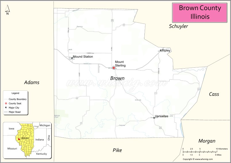
About Brown County Map, Illinois: The map showing the county boundary, county seat, major cities, highways, water bodies and neighbouring counties.
Most Viewed Illinois Links
Brown County, Illinois
Brown County is a county located in the U.S. state of Illinois. It's county seat is Mount Sterling. As per 2020 census, the population of Brown County is 6421 people and population density is square miles. According to the United States Census Bureau, the county has a total area of 305 sq mi (790 km2). Brown County was established on 1839.
Facts about Brown County, Illinois
| Country | United States |
| State | Illinois |
| Region | Western Illinois |
| County Seat | Mount Sterling |
| Named After | Jacob Brown |
| Established | 1839 |
| Organized | 1839 |
| Coordinates | 39.96° N, 90.75° W |
| Total Area | ~306 sq mi |
| Land Area | ~306 sq mi |
| Water Area | ~0.4 sq mi |
| Population (2020) | ~6,244 |
| Population Rank | One of the least populous counties in Illinois |
| Largest City | Mount Sterling |
| Main Industries | Agriculture, Government Services, Small Manufacturing |
| Major Highway | U.S. Route 24 |
| Time Zone | Central Time (UTC−06:00) |
| Known For | Rural farmland, small-town communities, Illinois River proximity |
| Website | https://www.browncoil.org |
Ctities in Brown county
| City Name | Type | Population (2020) | Pop. Density | Area |
|---|---|---|---|---|
| Mound Station | Village | 117 | 225.4/sq mi (87.0/km2) | 0.519 sq mi (1.34 km2) |
| Mount Sterling | City | 2,006 | 1,810.5/sq mi (699.0/km2) | 1.108 sq mi (2.87 km2) |
| Ripley | Village | 53 | 139.8/sq mi (54.0/km2) | 0.379 sq mi (0.98 km2) |
| Versailles | Village | 446 | 478.0/sq mi (184.6/km2) | 0.933 sq mi (2.42 km2) |
Roads and Highways in Brown County, Illinois
Brown County is connected by a few key highways that provide access to nearby towns and the Illinois River region, making travel simple across west-central Illinois.
- U.S. Route 24 – runs east-west through the county, connecting Mount Sterling to Quincy and extending toward central Illinois
- Illinois Route 99 – runs north-south, linking Mount Sterling to Beardstown and Rushville
- Illinois Route 107 – connects Mount Sterling to Griggsville and Pike County
- Illinois Route 125 – runs east-west across the northern part of the county, connecting Beardstown to Rushville
Neighboring Counties of Brown County
- Schuyler County (north)
- Cass County (east)
- Morgan County (southeast)
- Pike County (south)
- Adams County (west)
Top Attractions in Brown County, Illinois
Brown County offers a quiet rural setting with scenic landscapes, local history, and outdoor spaces perfect for a relaxing visit.
- Mount Sterling Historic Square – A charming downtown area with historic buildings and local shops.
- Brown County Courthouse – A classic courthouse located in the heart of Mount Sterling.
- Siloam Springs State Park – A nearby natural area with camping, fishing, and hiking opportunities.
- Timewell Park – A small community park with open green space and recreational areas.
- La Moine River Area – Offers scenic views and opportunities for fishing and nature walks.
- Brown County Fairgrounds – Hosts local events and the annual county fair.
- Historic Homes of Mount Sterling – Features several well-preserved historic residences.
Distance from Brown County to Nearby Cities
- Mount Sterling to Quincy – 45 mi (72 km)
- Mount Sterling to Jacksonville – 50 mi (80 km)
- Mount Sterling to Springfield – 80 mi (129 km)
- Mount Sterling to Peoria – 95 mi (153 km)
- Mount Sterling to St. Louis – 150 mi (241 km)
FAQs about Brown County
Brown County is located in west-central Illinois, near the Illinois River and surrounded by rural farmland.
The county is known for its quiet countryside, historic town of Mount Sterling, and nearby outdoor recreation areas.
Mount Sterling is the county seat and the largest city in Brown County.
Yes, visitors can enjoy parks, river areas, and nearby state parks for hiking, fishing, and camping.
Brown County is accessible via U.S. Route 24 and several Illinois state highways connecting it to nearby regions.
- Adams County Map
- Alexander County Map
- Bond County Map
- Boone County Map
- Brown County Map
- Bureau County Map
- Calhoun County Map
- Carroll County Map
- Cass County Map
- Champaign County Map
- Christian County Map
- Clark County Map
- Clay County Map
- Clinton County Map
- Coles County Map
- Cook County Map
- Crawford County Map
- Cumberland County Map
- DeKalb County Map
- DeWitt County Map
- Douglas County Map
- DuPage County Map
- Edgar County Map
- Edwards County Map
- Effingham County Map
- Fayette County Map
- Ford County Map
- Franklin County Map
- Fulton County Map
- Gallatin County Map
- Greene County Map
- Grundy County Map
- Hamilton County Map
- Hancock County Map
- Hardin County Map
- Henderson County Map
- Henry County Map
- Iroquois County Map
- Jackson County Map
- Jasper County Map
- Jefferson County Map
- Jersey County Map
- Jo Daviess County Map
- Johnson County Map
- Kane County Map
- Kankakee County Map
- Kendall County Map
- Knox County Map
- Lake County Map
- LaSalle County Map
- Lawrence County Map
- Lee County Map
- Livingston County Map
- Logan County Map
- McDonough County Map
- McHenry County Map
- McLean County Map
- Macon County Map
- Macoupin County Map
- Madison County Map
- Marion County Map
- Marshall County Map
- Mason County Map
- Massac County Map
- Menard County Map
- Mercer County Map
- Monroe County Map
- Montgomery County Map
- Morgan County Map
- Moultrie County Map
- Ogle County Map
- Peoria County Map
- Perry County Map
- Piatt County Map
- Pike County Map
- Pope County Map
- Pulaski County Map
- Putnam County Map
- Randolph County Map
- Richland County Map
- Rock Island County Map
- St Clair County Map
- Saline County Map
- Sangamon County Map
- Schuyler County Map
- Scott County Map
- Shelby County Map
- Stark County Map
- Stephenson County Map
- Tazewell County Map
- Union County Map
- Vermilion County Map
- Wabash County Map
- Warren County Map
- Washington County Map
- Wayne County Map
- White County Map
- Whiteside County Map
- Will County Map
- Williamson County Map
- Winnebago County Map
- Woodford County Map
- Alabama Counties
- Alaska boroughs
- Arizona Counties
- Arkansas Counties
- California County Map
- Colorado Counties
- Connecticut Counties
- Delaware Counties
- Florida County Map
- Georgia County Map
- Hawaii Counties
- Idaho Counties
- Illinois Counties
- Indiana Counties
- Iowa Counties
- Kansas Counties
- Kentucky Counties
- Louisiana Counties
- Maine Counties
- Maryland Counties
- Massachusetts Counties
- Michigan County Map
- Minnesota Counties
- Mississippi Counties
- Missouri Counties
- Montana Counties
- Nebraska Counties
- Nevada Counties
- New York Counties
- New Hampshire Counties
- New Jersey Counties
- New Mexico Counties
- North Carolina Counties
- North Dakota Counties
- Ohio County Map
- Oklahoma Counties
- Oregon Counties
- Pennsylvania Counties
- Rhode Island Counties
- South Carolina Counties
- South Dakota Counties
- Map of Tennessee
- Texas County Map
- Utah Counties
- Vermont Counties
- Virginia Counties
- Washington Counties
- West Virginia Counties
- Wisconsin Counties
- Wyoming Counties