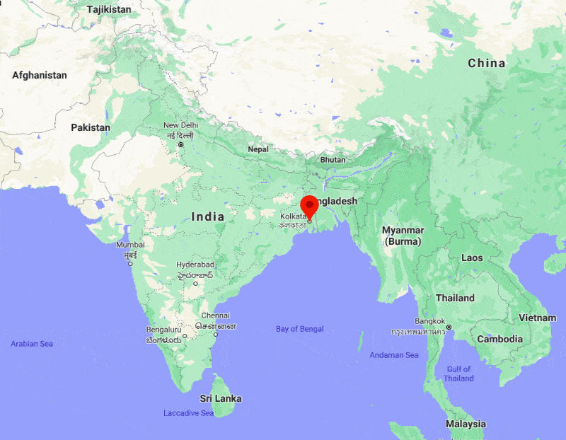
Kolata is the capital of the Indian state of West Bengal. Kolata is situated on the eastern bank of the Hooghly River, It's lies between latitudes 22.5697222 and longitudes 88.3697205. The Kolata city is approximately 80 kilometres west of the border with Bangladesh. Kolkata is the 7th-most populous city in India, with an estimated population of 1.49 crores as of 2020.
Kolkata Location Map, West Bengal, India

Where is Kolkata Located?
Kolata is the capital of the Indian state of West Bengal. Kolkata lies between 22°34′03″ North latitudes and 88°22′12° East longitudes. The city covers an area of about 206.08 km2 with a population of 4496694 people.
Kolkata City Facts
| Info | Datails |
|---|---|
| City Name | Kolkata |
| Country | India |
| State | West Bengal |
| District | Kolkata |
| Coordinates | 22°34′03″N 88°22′12″E |
| Area | 206.08 km2 |
| Elevation | 9 m |
| Population | 4,496,694 |
| Time Zone | UTC+5:30 (IST) |
| Language | Bengali |
| Pincode(s) | 700001 |
| STD Code | 33 |
| Nearest Airport | Netaji Subhas Chandra Bose International Airport |
| National Highway | Highway NH19 |
| Website | www.kmcgov.in |
Places to Visit in Kolkata
The top attractions to visit in Kolkata are: Victoria Memorial, Indian Museum, Howrah Bridge, Science City, James Prinsep Ghat, Fort William, India, Kalighat, Zoological Garden, Alipore Zoo, NICCO PARK KOLKATA, ISKCON Kolkata Sri Sri Radha Govinda, Babughat, Netaji Indoor Stadium
- Where is Agra
- Where is Ahmadabad
- Where is Ahmadnagar
- Where is Ajmer
- Where is Akola
- Where is Aligarh
- Where is Allahabad
- Where is Amravati
- Where is Amritsar
- Where is Asansol
- Where is Aurangabad
- Where is Bareilly
- Where is Belgaum
- Where is Benares
- Where is Bengaluru
- Where is Bhatpara
- Where is Bhavnagar
- Where is Bhilai
- Where is Bhiwandi
- Where is Bhopal
- Where is Bhubaneswar
- Where is Bikaner
- Where is Bokaro
- Where is Calcutta
- Where is Calicut
- Where is Chandigarh
- Where is Chennai
- Where is Cochin
- Where is Coimbatore
- Where is Cuttack
- Where is Dehra Dun
- Where is Durgapur
- Where is Faridabad
- Where is Gaya
- Where is Ghaziabad
- Where is Gorakhpur
- Where is Gulbarga
- Where is Guntur
- Where is Guwahati
- Where is Gwalior
- Where is Haora
- Where is Hubli
- Where is Hyderabad
- Where is Indore
- Where is Joshimath
- Where is Jabalpur
- Where is Jaipur
- Where is Jalandhar
- Where is Jalgaon
- Where is Jammu
- Where is Jamnagar
- Where is Jamshedpur
- Where is Jhansi
- Where is Jodhpur
- Where is Kalyan
- Where is Kanpur
- Where is Kolhapur
- Where is Korba
- Where is Kota
- Where is Lucknow
- Where is Ludhiana
- Where is Madurai
- Where is Malegaon
- Where is Mangalore
- Where is Meerut
- Where is Moradabad
- Where is Mysore
- Where is Nagpur
- Where is Nangi
- Where is Nasik
- Where is Nellore
- Where is Panihati
- Where is Patna
- Where is Pimpri
- Where is Pune
- Where is Quilon
- Where is Raipur
- Where is Rajkot
- Where is Ranchi
- Where is Rourkela
- Where is Saharanpur
- Where is Salem
- Where is Shiliguri
- Where is Solapur
- Where is Srinagar
- Where is Surat
- Where is Teni
- Where is Thane
- Where is Thiruvananthapuram
- Where is Tiruchchirappalli
- Where is Tirunelveli
- Where is Tiruppur
- Where is Udaipur
- Where is Ujjain
- Where is Ulhasnagar
- Where is Vadodara
- Where is Vijayawada
- Where is Vishakhapatnam
- Where is Warangal
