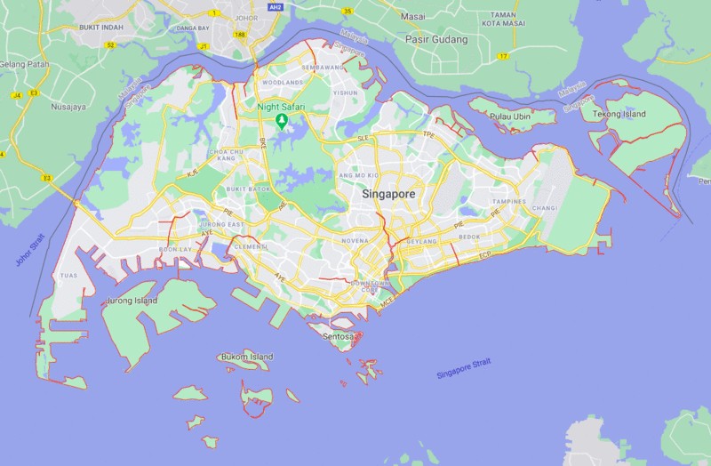
Singapore officially the Republic of Singapore, is a sovereign island city-country in maritime Southeast Asia.
Map of Singapore

About Singapore Map
The map also shows the Strait of Johar that separates the country from Malaysia. Both large and small islands that make up Singapore are also shown in the map. Singapore is spread over total area of 725.7 sq km (280.2 sq mi). The map of Singapore clearly defines the geographical and political contours of the country. The Singapore map provides detailed information on major places of tourist destinations and prominent cities of the country. The Republic of Singapore holds a population of 5,703,600 as of 2019. The Singapore travel guide provides the tourists with a comprehensive list of notable places of tourist attractions. Chinese and Japanese Garden, Mandai Orchid Gardens, Bukit Timah Nature Reserve, Fort Canning Park and Singapore Botanic Gardens are some of the major tourist attractions of the Country.
Major Cities, Towns & Areas in Singapore
| Rank | Name | Region | Pop. (2019) | Rank | Name | Region | Pop.(2019) |
|---|---|---|---|---|---|---|---|
| 1 | Bedok | East | 279,380 | 11 | Bukit Batok | West | 153,740 |
| 2 | Jurong West | West | 264,860 | 12 | Bukit Merah | Central | 151,980 |
| 3 | Tampines | East | 256,730 | 13 | Pasir Ris | East | 148,020 |
| 4 | Woodlands | North | 254,730 | 14 | Bukit Panjang | West | 139,280 |
| 5 | Sengkang | North-East | 244,600 | 15 | Toa Payoh | Central | 120,650 |
| 6 | Hougang | North-East | 226,240 | 16 | Serangoon | North-East | 116,310 |
| 7 | Yishun | North | 220,320 | 17 | Geylang | Central | 110,200 |
| 8 | Choa Chu Kang | West | 190,890 | 18 | Kallang | Central | 101,520 |
| 9 | Punggol | North-East | 170,560 | 19 | Queenstown | Central | 96,340 |
| 10 | Ang Mo Kio | North-East | 163,950 | 20 | Sembawang | North | 95,920 |
- Where is Afghanistan
- Where is Armenia
- Where is Azerbaijan
- Where is Bahrain
- Where is Bangladesh
- Where is Bhutan
- Where is Brunei
- Where is Cambodia
- Where is China
- Where is Georgia
- Where is Hong Kong
- Where is India
- Where is Indonesia
- Where is Iran
- Where is Iraq
- Where is Israel
- Where is Japan
- Where is Jordan
- Where is Kazakhstan
- Where is Kuwait
- Where is Kyrgyzstan
- Where is Laos
- Where is Lebanon
- Where is Macau
- Where is Malaysia
- Where is Maldives
- Where is Mongolia
- Where is Myanmar
- Where is Nepal
- Where is North Korea
- Where is Oman
- Where is Pakistan
- Where is Philippines
- Where is Qatar
- Where is Russia
- Where is Saudi Arabia
- Where is Singapore
- Where is South Korea
- Where is Sri Lanka
- Where is Syria
- Where is Taiwan
- Where is Tajikistan
- Where is Thailand
- Where is Turkey
- Where is Turkmenistan
- United Arab Emirates
- Where is Uzbekistan
- Where is Vietnam
- Where is Yemen
- Where is Abu Dhabi
- Where is Amman
- Where is Ankara
- Where is Baghdad
- Where is Baku
- Where is Bangkok
- Where is Bangalore
- Where is Beijing
- Where is Bishkek
- Where is Damascus
- Where is Dhaka
- Where is Dubai
- Where is Doha
- Where is Hanoi
- Where is Islamabad
- Where is Jakarta
- Where is Jerusalem
- Where is Kabul
- Where is Kathmandu
- Where is Kuala Lumpur
- Where is Kuwait City
- Where is Manila
- Where is Moscow
- Where is Mumbai
- Where is Muscat
- Where is New Delhi
- Where is Riyadh
- Where is Sanaa
- Where is Shanghai
- Where is Seoul
- Where is Taipei
- Where is Tehran
- Where is Tokyo
