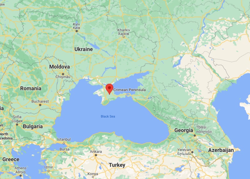
Crimea, formerly known as the Tauric Peninsula, is a peninsula in Eastern Europe surrounded by the northern coast of Black Sea and the Sea of Azov. Simferopol is the capital city of the Crimea, officially part of Ukraine.
Location Map of Crimea

Most Viewd Maps
Where is Crimea Located?
Crimea is a peninsula of Ukraine located on the northern coast of the Black Sea and on the western coast of the Sea of Azov, bordering Kherson Oblast from the North. Crimea is one of the region of Ukraine is in the Europe continent and the latitude and longitude for the country are 44.9333° N, and 34.0999° E . Area Crimea is 26,100 km2 (10,077 sq mi). On 19 May, 1992 Crimea is an autonomous parliamentary republic within Ukraine and is governed by the Constitution of Crimea in accordance with the laws of Ukraine. Crimea is subdivided into 25 regions: 14 raions (districts) and 11 city municipalities. Crimea is a disputed region claimed by both Ukraine and Russia as part of either southern Ukraine or southwestern Russia.
Crimea Facts & Information
| Official Name | Republic of Crimea |
| Capital of Crimea | Simferopol |
| Coordinates | 44.9333° N, 34.0999° E |
| Country | Ukraine | Location | Located on the northern coast of the Black Sea |
| Founded | Oct 18, 1921 |
| Crimean War Timeline | 1853–1856 |
| Crimean parliament Established | October 14, 1993 |
| Official Language | Ukrainian |
| Ethnic Groups | 58.32% Russians, 24.32% Ukrainians, 12.10% Crimean Tatars |
| Government | Autonomous Republic |
| Area | 26,100 km2 |
| Population | 1,973,185 |
| Currency | Ukrainian hryvnia (UAH) |
| Time zone | EET (UTC+2), in Summer; EEST (UTC+3) |
| Calling code | +380 |
- Where is Albania
- Where is Andorra
- Where is Austria
- Where is Belarus
- Where is Belgium
- Bosnia and Herzegovina
- Where is Bulgaria
- Where is Croatia
- Where is Cyprus
- Where is Czech Republic
- Where is Denmark
- Where is England
- Where is Estonia
- Where is Finland
- Where is France
- Where is Germany
- Where is Greece
- Where is Hungary
- Where is Iceland
- Where is Ireland
- Where is Italy
- Where is Latvia
- Where is Liechtenstein
- Where is Lithuania
- Where is Luxemburg
- Where is Malta
- Where is Moldova
- Where is Monaco
- Where is Montenegro
- Where is Netherlands
- Where is Northern Ireland
- Where is Norway
- Where is Poland
- Republic Of Macedonia
- Where is Romania
- Where is Russia
- Where is San Marino
- Where is Scotland
- Where is Serbia
- Where is Slovakia
- Where is Slovenia
- Where is Spain
- Where is Sweden
- Where is Switzerland
- Where is Turkey
- Where is Ukraine
- Where is UK
- Where is Wales
- Where is Amsterdam
- Where is Athens
- Where is Belfast
- Where is Berlin
- Where is Brussels
- Where is Bucharest
- Where is Budapest
- Where is Copenhagen
- Where is Edinburgh
- Where is Helsinki
- Where is Kiev
- Where is Lisbon
- Where is London
- Where is Madrid
- Where is Moscow
- Where is Oslo
- Where is Paris
- Where is Riga
- Where is Rome
- Where is Sofia
- Where is Stockholm
- Where is Vienna
- Where is Warsaw
